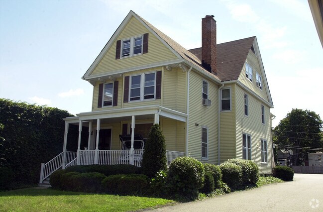
Property Record
149 South St, Morristown, NJ 07960
NEARBY LISTINGS FOR SALE OR LEASE
Property Detail
149 South St
Newark, NJ-PA
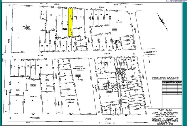
Morris
24-06204-0000-00017
New Jersey
Commercialnec
17
2024
0.23 AC
2025
Morristown Region
043700
Northern New Jersey
6,514 SF
DEMOGRAPHICS near 149 South St
1 Mile
3 Mile
5 Mile
2024 Total Population
18,802
55,858
118,882
2029 Population
18,854
55,965
118,862
Pop Growth 2024-2029
+ 0.28%
+ 0.19%
(0.02%)
Average Age
39
41
41
2024 Total Households
8,378
22,069
44,289
HH Growth 2024-2029
+ 0.54%
+ 0.35%
+ 0.08%
Median Household Inc
$113,315
$138,110
$145,460
Avg Household Size
2.10
2.40
2.50
2024 Avg HH Vehicles
2.00
2.00
2.00
Median Home Value
$589,900
$653,684
$676,018
Median Year Built
1966
1967
1968
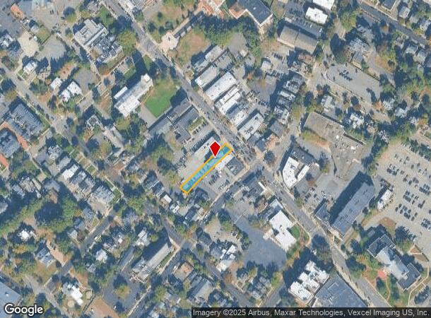
Nearby Places
Map Layers
Map Styles
 Street
 Aerial
- Restaurants
- Banks
- Shops
- Fitness
- Groceries
PUBLIC TRANSPORTATION
COMMUTER RAIL
Morristown (Morris & Essex Morristown Line - NJ Transit Commuter Rail (NJ Transit))
DRIVE
WALK
Distance
Morristown (Morris & Essex Morristown Line - NJ Transit Commuter Rail (NJ Transit))
1 min
8 min
0.4 mi
Convent Station (Morris & Essex Morristown Line - NJ Transit Commuter Rail (NJ Transit))
DRIVE
WALK
Distance
Convent Station (Morris & Essex Morristown Line - NJ Transit Commuter Rail (NJ Transit))
5 min
2.4 mi
AIRPORT
Newark Liberty International
DRIVE
WALK
Distance
Newark Liberty International
28 min
21.7 mi
Freight Ports
Maher Terminal
DRIVE
WALK
Distance
Maher Terminal
31 min
22.2 mi
Nearby Properties
Address
Land Use
TOTAL SIZE
Lot Size
Zoning
Address
Land Use
TOTAL SIZE
Lot Size
Zoning
596 SF
64.81 AC
OBRL
Address
Land Use
TOTAL SIZE
Lot Size
Zoning
23.01 AC
R-2
Address
Land Use
TOTAL SIZE
Lot Size
Zoning
64.80 AC
C-4
Address
Land Use
TOTAL SIZE
Lot Size
Zoning
72,698 SF
133.64 AC
U
Address
Land Use
TOTAL SIZE
Lot Size
Zoning
1.55 AC
Address
Land Use
TOTAL SIZE
Lot Size
Zoning
2.82 AC
Address
Land Use
TOTAL SIZE
Lot Size
Zoning
13,428 SF
108.84 AC
OSGU
Address
Land Use
TOTAL SIZE
Lot Size
Zoning
396,029 SF
40.08 AC
OL40
Address
Land Use
TOTAL SIZE
Lot Size
Zoning
10.94 AC
Address
Land Use
TOTAL SIZE
Lot Size
Zoning
8.64 AC
RG
Address
Land Use
TOTAL SIZE
Lot Size
Zoning
43.60 AC
C-4
Address
Land Use
TOTAL SIZE
Lot Size
Zoning
Address
Land Use
TOTAL SIZE
Lot Size
Zoning
18.42 AC
RM
Address
Land Use
TOTAL SIZE
Lot Size
Zoning
475,100 SF
38 AC
OL40
Address
Land Use
TOTAL SIZE
Lot Size
Zoning
0.36 AC
UR
Address
Land Use
TOTAL SIZE
Lot Size
Zoning
10.42 AC
Address
Land Use
TOTAL SIZE
Lot Size
Zoning
304,213 SF
21.73 AC
PODS
Address
Land Use
TOTAL SIZE
Lot Size
Zoning
34.13 AC
OB
Address
Land Use
TOTAL SIZE
Lot Size
Zoning
3.13 AC
CBD
Address
Land Use
TOTAL SIZE
Lot Size
Zoning
14.50 AC
RG
Address
Land Use
TOTAL SIZE
Lot Size
Zoning
0.57 AC
CBD
Address
Land Use
TOTAL SIZE
Lot Size
Zoning
0.41 AC
UR
Address
Land Use
TOTAL SIZE
Lot Size
Zoning
0.35 AC
UR
Address
Land Use
TOTAL SIZE
Lot Size
Zoning
1.71 AC
Address
Land Use
TOTAL SIZE
Lot Size
Zoning
322,575 SF
32.28 AC
OL40
Address
Land Use
TOTAL SIZE
Lot Size
Zoning
6.56 AC
OB
Address
Land Use
TOTAL SIZE
Lot Size
Zoning
6.64 AC
Address
Land Use
TOTAL SIZE
Lot Size
Zoning
25.14 AC
I-B3
Address
Land Use
TOTAL SIZE
Lot Size
Zoning
2,380 SF
1.32 AC
RC
Address
Land Use
TOTAL SIZE
Lot Size
Zoning
19.35 AC
0L40
The World's #1 Commercial Real Estate Marketplace
Connect with us
© 2025 CoStar Group
The information above has been obtained from sources believed reliable. While we do not doubt its accuracy we have not verified it and make no guarantee, warranty or representation about it. It is your responsibility to independently confirm its accuracy and completeness. Any projections, opinions, assumptions, or estimates used are for example only and do not represent the current or future performance of the property. The value of this transaction to you depends on tax and other factors which should be evaluated by your tax, financial, and legal advisors. You and your advisors should conduct a careful, independent investigation of the property to determine to your satisfaction the suitability of the property for your needs.