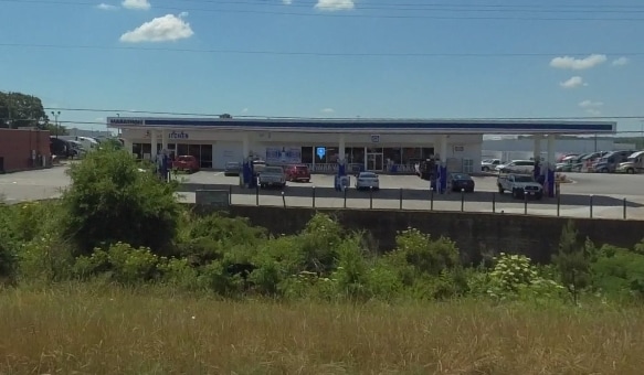
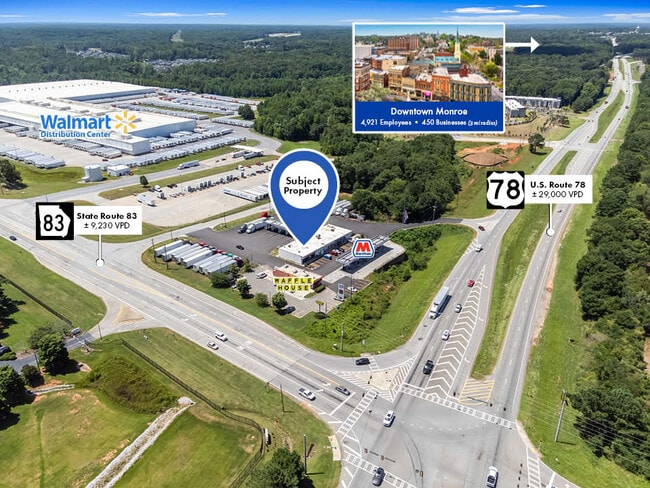
Property Record
1490 Highway 78, Monroe, GA 30655


NEARBY LISTINGS FOR SALE OR LEASE
Property Detail
1490 Highway 78
Atlanta-Sandy Springs-Roswell, GA
09107 - Countywide-Assorted-Comm
M023000000011D00
3.83AC
Commercialnec
Walton
X
Georgia
13297C0135E
108
2024
3.83 AC
2025
Walton County
110301
Atlanta
7,000 SF
DEMOGRAPHICS near 1490 Highway 78
1 Mile
3 Mile
5 Mile
2024 Total Population
345
18,906
32,074
2029 Population
404
21,977
37,304
Pop Growth 2024-2029
+ 17.10%
+ 16.24%
+ 16.31%
Average Age
42
39
40
2024 Total Households
144
7,161
11,971
HH Growth 2024-2029
+ 17.36%
+ 16.62%
+ 16.67%
Median Household Inc
$43,333
$41,085
$53,134
Avg Household Size
2.40
2.60
2.60
2024 Avg HH Vehicles
2.00
2.00
2.00
Median Home Value
$181,428
$185,988
$219,972
Median Year Built
1975
1984
1989
Nearby Places
Map Layers
Map Styles
 Street
 Aerial
- Restaurants
- Banks
- Shops
- Fitness
- Groceries
Nearby Properties
Address
Land Use
TOTAL SIZE
Lot Size
Zoning
Address
Land Use
TOTAL SIZE
Lot Size
Zoning
63,172 SF
225.97 AC
R1 P
Address
Land Use
TOTAL SIZE
Lot Size
Zoning
174,303 SF
26.22 AC
PCD
Address
Land Use
TOTAL SIZE
Lot Size
Zoning
210,000 SF
36 AC
M1
Address
Land Use
TOTAL SIZE
Lot Size
Zoning
375,544 SF
128.40 AC
M1
Address
Land Use
TOTAL SIZE
Lot Size
Zoning
185,112 SF
26.64 AC
PCD
Address
Land Use
TOTAL SIZE
Lot Size
Zoning
122,949 SF
28.37 AC
R1 P
Address
Land Use
TOTAL SIZE
Lot Size
Zoning
319.22 AC
B3 R1
Address
Land Use
TOTAL SIZE
Lot Size
Zoning
16,880 SF
55.23 AC
M1
Address
Land Use
TOTAL SIZE
Lot Size
Zoning
268,431 SF
14.74 AC
M1
Address
Land Use
TOTAL SIZE
Lot Size
Zoning
108,396 SF
40 AC
A1 R1
Address
Land Use
TOTAL SIZE
Lot Size
Zoning
58,980 SF
8.84 AC
PCD
Address
Land Use
TOTAL SIZE
Lot Size
Zoning
140,800 SF
12.05 AC
I1
Address
Land Use
TOTAL SIZE
Lot Size
Zoning
2,640 SF
64.81 AC
R1A
Address
Land Use
TOTAL SIZE
Lot Size
Zoning
70,400 SF
17 AC
M1
Address
Land Use
TOTAL SIZE
Lot Size
Zoning
159,604 SF
17.50 AC
M1
Address
Land Use
TOTAL SIZE
Lot Size
Zoning
7,200 SF
18 AC
A1
Address
Land Use
TOTAL SIZE
Lot Size
Zoning
52,185 SF
3.64 AC
PCD
Address
Land Use
TOTAL SIZE
Lot Size
Zoning
27,300 SF
8 AC
PCD
Address
Land Use
TOTAL SIZE
Lot Size
Zoning
90,557 SF
11.46 AC
B3
Address
Land Use
TOTAL SIZE
Lot Size
Zoning
104,104 SF
17.55 AC
R1A
Address
Land Use
TOTAL SIZE
Lot Size
Zoning
37,600 SF
5.96 AC
B2
Address
Land Use
TOTAL SIZE
Lot Size
Zoning
3,912 SF
221.14 AC
MIX
Address
Land Use
TOTAL SIZE
Lot Size
Zoning
30,722 SF
2.54 AC
B2
Address
Land Use
TOTAL SIZE
Lot Size
Zoning
4,830 SF
9.65 AC
PCD
Address
Land Use
TOTAL SIZE
Lot Size
Zoning
92,250 SF
3.64 AC
PCD
Address
Land Use
TOTAL SIZE
Lot Size
Zoning
32,343 SF
4.11 AC
P
Address
Land Use
TOTAL SIZE
Lot Size
Zoning
11,953 SF
1.39 AC
B2
Address
Land Use
TOTAL SIZE
Lot Size
Zoning
140.98 AC
M1
Address
Land Use
TOTAL SIZE
Lot Size
Zoning
10,350 SF
11.74 AC
M1
Address
Land Use
TOTAL SIZE
Lot Size
Zoning
15,402 SF
14.67 AC
R2
The World's #1 Commercial Real Estate Marketplace
Connect with us
© 2025 CoStar Group
The information above has been obtained from sources believed reliable. While we do not doubt its accuracy we have not verified it and make no guarantee, warranty or representation about it. It is your responsibility to independently confirm its accuracy and completeness. Any projections, opinions, assumptions, or estimates used are for example only and do not represent the current or future performance of the property. The value of this transaction to you depends on tax and other factors which should be evaluated by your tax, financial, and legal advisors. You and your advisors should conduct a careful, independent investigation of the property to determine to your satisfaction the suitability of the property for your needs.