Property Record
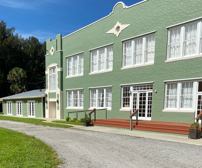
1490 Marie St, Malabar, FL 32950

NEARBY LISTINGS FOR SALE OR LEASE
Property Detail
1490 Marie St
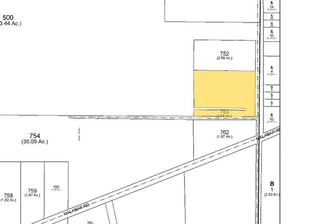
28-37-36-00-00753.0-0000.00
Indian River Fruit & Truck Lands
Communitycenter
PART OF S 1/2 OF NE 1/4 OF SE 1/4 AS DESC IN ORB 3165 PG 4577
X
Brevard
12009C0614H
Florida
2024
2.52 AC
2025
Brevard County
065231
Orlando
8,706 SF
Palm Bay-Melbourne-Titusville, FL
DEMOGRAPHICS near 1490 Marie St
1 Mile
3 Mile
5 Mile
2024 Total Population
1,734
21,196
76,450
2029 Population
1,894
23,195
84,395
Pop Growth 2024-2029
+ 9.23%
+ 9.43%
+ 10.39%
Average Age
44
47
45
2024 Total Households
710
8,854
33,093
HH Growth 2024-2029
+ 9.01%
+ 9.35%
+ 10.23%
Median Household Inc
$58,912
$57,551
$51,558
Avg Household Size
2.40
2.30
2.20
2024 Avg HH Vehicles
2.00
2.00
2.00
Median Home Value
$259,374
$252,599
$229,450
Median Year Built
1976
1984
1986
Nearby Places
Map Layers
Map Styles
 Street
 Aerial
- Restaurants
- Banks
- Shops
- Fitness
- Groceries
PUBLIC TRANSPORTATION
AIRPORT
Melbourne Orlando International
DRIVE
WALK
Distance
Melbourne Orlando International
22 min
10.2 mi
Freight Ports
Port Canaveral
DRIVE
WALK
Distance
Port Canaveral
57 min
45.4 mi
SALE & LEASE HISTORY
LISTING DATE
SALE/LEASE

Aug 12, 2020
For Sale
Nearby Properties
Address
Land Use
TOTAL SIZE
Lot Size
Zoning
Address
Land Use
TOTAL SIZE
Lot Size
Zoning
1,695,838 SF
106.06 AC
Address
Land Use
TOTAL SIZE
Lot Size
Zoning
282,680 SF
16 AC
IU
Address
Land Use
TOTAL SIZE
Lot Size
Zoning
326,454 SF
14.20 AC
RM20
Address
Land Use
TOTAL SIZE
Lot Size
Zoning
2,366 SF
32.43 AC
SR
Address
Land Use
TOTAL SIZE
Lot Size
Zoning
4,000 SF
12.20 AC
IU
Address
Land Use
TOTAL SIZE
Lot Size
Zoning
1,380 SF
21.87 AC
IU
Address
Land Use
TOTAL SIZE
Lot Size
Zoning
762 SF
49.89 AC
GML
Address
Land Use
TOTAL SIZE
Lot Size
Zoning
408,025 SF
24.10 AC
LI
Address
Land Use
TOTAL SIZE
Lot Size
Zoning
143,529 SF
7.76 AC
RM20
Address
Land Use
TOTAL SIZE
Lot Size
Zoning
161,823 SF
619.70 AC
GML
Address
Land Use
TOTAL SIZE
Lot Size
Zoning
242,454 SF
14.13 AC
LI
Address
Land Use
TOTAL SIZE
Lot Size
Zoning
352,735 SF
130.85 AC
Address
Land Use
TOTAL SIZE
Lot Size
Zoning
135,917 SF
2.92 AC
HC
Address
Land Use
TOTAL SIZE
Lot Size
Zoning
104,620 SF
12.82 AC
IU
Address
Land Use
TOTAL SIZE
Lot Size
Zoning
35.96 AC
GML
Address
Land Use
TOTAL SIZE
Lot Size
Zoning
222,925 SF
12.75 AC
PUD
Address
Land Use
TOTAL SIZE
Lot Size
Zoning
76,534 SF
4.33 AC
HC
Address
Land Use
TOTAL SIZE
Lot Size
Zoning
202,908 SF
34.94 AC
LI
Address
Land Use
TOTAL SIZE
Lot Size
Zoning
48,492 SF
17.45 AC
OI
Address
Land Use
TOTAL SIZE
Lot Size
Zoning
109,650 SF
10.32 AC
CG
Address
Land Use
TOTAL SIZE
Lot Size
Zoning
97,728 SF
12.77 AC
IU
Address
Land Use
TOTAL SIZE
Lot Size
Zoning
78,357 SF
8.47 AC
BU1
Address
Land Use
TOTAL SIZE
Lot Size
Zoning
31.07 AC
GML
Address
Land Use
TOTAL SIZE
Lot Size
Zoning
103,422 SF
6.01 AC
LI
Address
Land Use
TOTAL SIZE
Lot Size
Zoning
80,425 SF
12.78 AC
HC
Address
Land Use
TOTAL SIZE
Lot Size
Zoning
1,535 SF
3.85 AC
GML
Address
Land Use
TOTAL SIZE
Lot Size
Zoning
93,240 SF
4.67 AC
LI
Address
Land Use
TOTAL SIZE
Lot Size
Zoning
4.23 AC
GML
Address
Land Use
TOTAL SIZE
Lot Size
Zoning
59,088 SF
4.84 AC
LI
Address
Land Use
TOTAL SIZE
Lot Size
Zoning
64,984 SF
7.20 AC
RM15
The World's #1 Commercial Real Estate Marketplace
Connect with us
© 2025 CoStar Group
The information above has been obtained from sources believed reliable. While we do not doubt its accuracy we have not verified it and make no guarantee, warranty or representation about it. It is your responsibility to independently confirm its accuracy and completeness. Any projections, opinions, assumptions, or estimates used are for example only and do not represent the current or future performance of the property. The value of this transaction to you depends on tax and other factors which should be evaluated by your tax, financial, and legal advisors. You and your advisors should conduct a careful, independent investigation of the property to determine to your satisfaction the suitability of the property for your needs.