Property Record
1490 Rock Springs Rd, Apopka, FL 32712
NEARBY LISTINGS FOR SALE OR LEASE
Property Detail
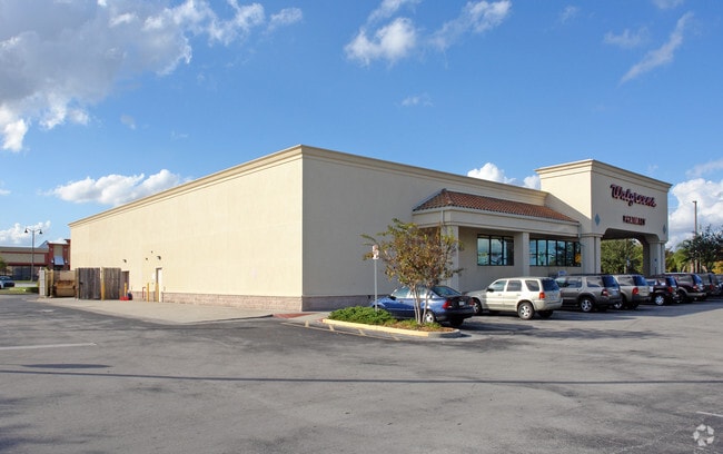
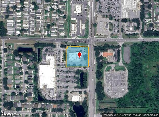
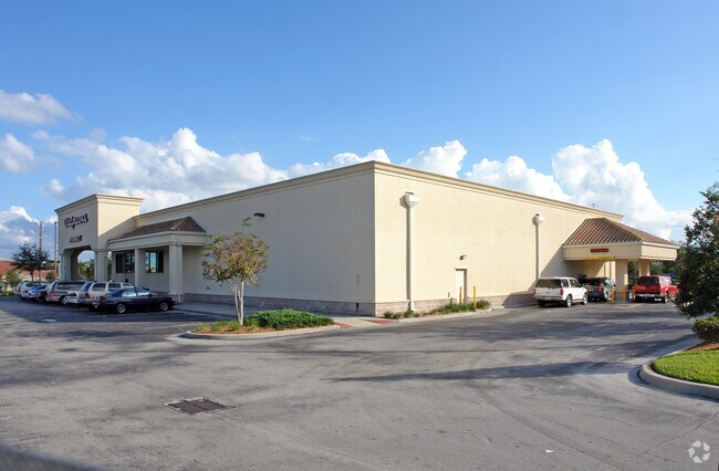
1490 Rock Springs Rd
Orlando-Kissimmee-Sanford, FL
Rock Springs Plaza
33-2028-8238-02-000
ROCK SPRINGS PLAZA 43/88 TRACT B
Storebuilding
Orange
X
Florida
12095C0110H
200
2024
1.79 AC
2025
NW Orange Outlying
017701
Orlando
15,885 SF
DEMOGRAPHICS near 1490 Rock Springs Rd
1 Mile
3 Mile
5 Mile
2024 Total Population
8,995
53,797
109,575
2029 Population
9,258
55,493
113,225
Pop Growth 2024-2029
+ 2.92%
+ 3.15%
+ 3.33%
Average Age
39
40
40
2024 Total Households
2,838
17,910
37,938
HH Growth 2024-2029
+ 2.92%
+ 3.08%
+ 3.30%
Median Household Inc
$91,494
$81,420
$74,982
Avg Household Size
3.00
2.90
2.80
2024 Avg HH Vehicles
2.00
2.00
2.00
Median Home Value
$312,389
$322,804
$314,176
Median Year Built
1997
1994
1990
Nearby Places
Map Layers
Map Styles
 Street
 Aerial
- Restaurants
- Banks
- Shops
- Fitness
- Groceries
PUBLIC TRANSPORTATION
AIRPORT
Orlando Sanford International
DRIVE
WALK
Distance
Orlando Sanford International
38 min
22.1 mi
Orlando International
DRIVE
WALK
Distance
Orlando International
46 min
28.2 mi
Freight Ports
Port Canaveral
DRIVE
WALK
Distance
Port Canaveral
92 min
70.2 mi
Nearby Properties
Address
Land Use
TOTAL SIZE
Lot Size
Zoning
Address
Land Use
TOTAL SIZE
Lot Size
Zoning
792,152 SF
53.04 AC
O
Address
Land Use
TOTAL SIZE
Lot Size
Zoning
341,131 SF
39.88 AC
O
Address
Land Use
TOTAL SIZE
Lot Size
Zoning
313,324 SF
32.44 AC
PR
Address
Land Use
TOTAL SIZE
Lot Size
Zoning
275,446 SF
12.81 AC
I-L
Address
Land Use
TOTAL SIZE
Lot Size
Zoning
193,525 SF
10.07 AC
D-APK-I-L
Address
Land Use
TOTAL SIZE
Lot Size
Zoning
503,677 SF
27.63 AC
I-L
Address
Land Use
TOTAL SIZE
Lot Size
Zoning
83,209 SF
5,971.65 AC
A-2
Address
Land Use
TOTAL SIZE
Lot Size
Zoning
75.90 AC
MU-KPI
Address
Land Use
TOTAL SIZE
Lot Size
Zoning
67,945 SF
18.66 AC
O
Address
Land Use
TOTAL SIZE
Lot Size
Zoning
3,688 SF
71.90 AC
MU-KPI
Address
Land Use
TOTAL SIZE
Lot Size
Zoning
144,713 SF
10.10 AC
I-L
Address
Land Use
TOTAL SIZE
Lot Size
Zoning
121,241 SF
4.66 AC
I-L
Address
Land Use
TOTAL SIZE
Lot Size
Zoning
185,772 SF
16.70 AC
O
Address
Land Use
TOTAL SIZE
Lot Size
Zoning
178,662 SF
17.71 AC
PUD
Address
Land Use
TOTAL SIZE
Lot Size
Zoning
175,687 SF
15.13 AC
O
Address
Land Use
TOTAL SIZE
Lot Size
Zoning
361,926 SF
12.79 AC
I-L
Address
Land Use
TOTAL SIZE
Lot Size
Zoning
71,394 SF
8.56 AC
MU-D
Address
Land Use
TOTAL SIZE
Lot Size
Zoning
108,529 SF
18.20 AC
PUD
Address
Land Use
TOTAL SIZE
Lot Size
Zoning
136,824 SF
11.66 AC
C-C
Address
Land Use
TOTAL SIZE
Lot Size
Zoning
155,656 SF
22.32 AC
A-1
Address
Land Use
TOTAL SIZE
Lot Size
Zoning
189,143 SF
16.44 AC
O
Address
Land Use
TOTAL SIZE
Lot Size
Zoning
29 AC
D-APK-MU-K
Address
Land Use
TOTAL SIZE
Lot Size
Zoning
54,911 SF
22.75 AC
PD
Address
Land Use
TOTAL SIZE
Lot Size
Zoning
216,008 SF
19.20 AC
O
Address
Land Use
TOTAL SIZE
Lot Size
Zoning
104,860 SF
5.09 AC
PD
Address
Land Use
TOTAL SIZE
Lot Size
Zoning
135,895 SF
12.01 AC
P-D
Address
Land Use
TOTAL SIZE
Lot Size
Zoning
88,655 SF
1.92 AC
RSTD C-1
Address
Land Use
TOTAL SIZE
Lot Size
Zoning
86,063 SF
3.69 AC
MU-D
Address
Land Use
TOTAL SIZE
Lot Size
Zoning
67,867 SF
7.99 AC
PUD
Address
Land Use
TOTAL SIZE
Lot Size
Zoning
14.64 AC
AG
The World's #1 Commercial Real Estate Marketplace
Connect with us
© 2026 CoStar Group
The information above has been obtained from sources believed reliable. While we do not doubt its accuracy we have not verified it and make no guarantee, warranty or representation about it. It is your responsibility to independently confirm its accuracy and completeness. Any projections, opinions, assumptions, or estimates used are for example only and do not represent the current or future performance of the property. The value of this transaction to you depends on tax and other factors which should be evaluated by your tax, financial, and legal advisors. You and your advisors should conduct a careful, independent investigation of the property to determine to your satisfaction the suitability of the property for your needs.