Property Record
14901 Narcoossee Rd, Orlando, FL 32832
NEARBY LISTINGS FOR SALE OR LEASE
Property Detail
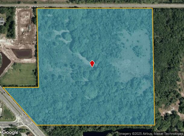
14901 Narcoossee Rd
Orlando-Kissimmee-Sanford, FL
Acreage & Unrec
32-2431-0000-00-010
SE1/4 OF SE1/4 (LESS N 250 FT & S 430 FT OF SW1/4 OF SE1/4 E OF PAVED ROAD) OF SEC 32-24-31
Vacantlandnec
Orange
A
Florida
12095C0675G
10
2024
42.43 AC
2025
SE Orange Outlying
016736
Orlando
DEMOGRAPHICS near 14901 Narcoossee Rd
1 Mile
3 Mile
5 Mile
2024 Total Population
7,695
32,606
66,524
2029 Population
8,687
36,820
74,785
Pop Growth 2024-2029
+ 12.89%
+ 12.92%
+ 12.42%
Average Age
37
37
37
2024 Total Households
2,534
11,132
22,237
HH Growth 2024-2029
+ 12.75%
+ 12.72%
+ 12.23%
Median Household Inc
$107,658
$102,613
$95,969
Avg Household Size
3.00
2.90
3.00
2024 Avg HH Vehicles
2.00
2.00
2.00
Median Home Value
$453,452
$441,726
$395,988
Median Year Built
2011
2011
2010
Nearby Places
Map Layers
Map Styles
 Street
 Aerial
- Restaurants
- Banks
- Shops
- Fitness
- Groceries
PUBLIC TRANSPORTATION
AIRPORT
Orlando International
DRIVE
WALK
Distance
Orlando International
21 min
12.2 mi
Orlando Sanford International
DRIVE
WALK
Distance
Orlando Sanford International
44 min
34.4 mi
Freight Ports
Port Canaveral
DRIVE
WALK
Distance
Port Canaveral
58 min
46.8 mi
Nearby Properties
Address
Land Use
TOTAL SIZE
Lot Size
Zoning
Address
Land Use
TOTAL SIZE
Lot Size
Zoning
2,494,314 SF
65.89 AC
PD/AN
Address
Land Use
TOTAL SIZE
Lot Size
Zoning
496,863 SF
13.92 AC
PD
Address
Land Use
TOTAL SIZE
Lot Size
Zoning
394,422 SF
54.48 AC
PD
Address
Land Use
TOTAL SIZE
Lot Size
Zoning
325,067 SF
13.38 AC
PD/AN
Address
Land Use
TOTAL SIZE
Lot Size
Zoning
463,236 SF
12.35 AC
PD
Address
Land Use
TOTAL SIZE
Lot Size
Zoning
387,339 SF
15.41 AC
PD
Address
Land Use
TOTAL SIZE
Lot Size
Zoning
351,162 SF
5.43 AC
P-D
Address
Land Use
TOTAL SIZE
Lot Size
Zoning
403,703 SF
11.96 AC
P-D
Address
Land Use
TOTAL SIZE
Lot Size
Zoning
397,515 SF
1.16 AC
P-D
Address
Land Use
TOTAL SIZE
Lot Size
Zoning
161,219 SF
30 AC
PD/AN
Address
Land Use
TOTAL SIZE
Lot Size
Zoning
91,094 SF
23.37 AC
PD
Address
Land Use
TOTAL SIZE
Lot Size
Zoning
266,284 SF
50.40 AC
IN
Address
Land Use
TOTAL SIZE
Lot Size
Zoning
93,174 SF
13.12 AC
PD/AN
Address
Land Use
TOTAL SIZE
Lot Size
Zoning
149,679 SF
5.27 AC
PD
Address
Land Use
TOTAL SIZE
Lot Size
Zoning
203,382 SF
16.71 AC
PD
Address
Land Use
TOTAL SIZE
Lot Size
Zoning
87,067 SF
20.42 AC
PD
Address
Land Use
TOTAL SIZE
Lot Size
Zoning
126,656 SF
1.98 AC
PD/AN
Address
Land Use
TOTAL SIZE
Lot Size
Zoning
90,917 SF
3.16 AC
P-D
Address
Land Use
TOTAL SIZE
Lot Size
Zoning
162,884 SF
12.76 AC
PD
Address
Land Use
TOTAL SIZE
Lot Size
Zoning
912 SF
20.84 AC
PD/AN
Address
Land Use
TOTAL SIZE
Lot Size
Zoning
50,430 SF
10.80 AC
OAC
Address
Land Use
TOTAL SIZE
Lot Size
Zoning
82,668 SF
7.51 AC
PD/AN
Address
Land Use
TOTAL SIZE
Lot Size
Zoning
18,354 SF
129.24 AC
OPD
Address
Land Use
TOTAL SIZE
Lot Size
Zoning
7,159 SF
231.82 AC
A-2
Address
Land Use
TOTAL SIZE
Lot Size
Zoning
68,043 SF
2.28 AC
PD
Address
Land Use
TOTAL SIZE
Lot Size
Zoning
59,432 SF
3.56 AC
PD
Address
Land Use
TOTAL SIZE
Lot Size
Zoning
85,084 SF
1.38 AC
PD
Address
Land Use
TOTAL SIZE
Lot Size
Zoning
39,949 SF
3.99 AC
PD
Address
Land Use
TOTAL SIZE
Lot Size
Zoning
17,634 SF
2.15 AC
P-D
Address
Land Use
TOTAL SIZE
Lot Size
Zoning
26,810 SF
3.36 AC
PD/AN
The World's #1 Commercial Real Estate Marketplace
Connect with us
© 2026 CoStar Group
The information above has been obtained from sources believed reliable. While we do not doubt its accuracy we have not verified it and make no guarantee, warranty or representation about it. It is your responsibility to independently confirm its accuracy and completeness. Any projections, opinions, assumptions, or estimates used are for example only and do not represent the current or future performance of the property. The value of this transaction to you depends on tax and other factors which should be evaluated by your tax, financial, and legal advisors. You and your advisors should conduct a careful, independent investigation of the property to determine to your satisfaction the suitability of the property for your needs.