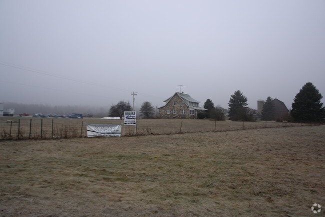
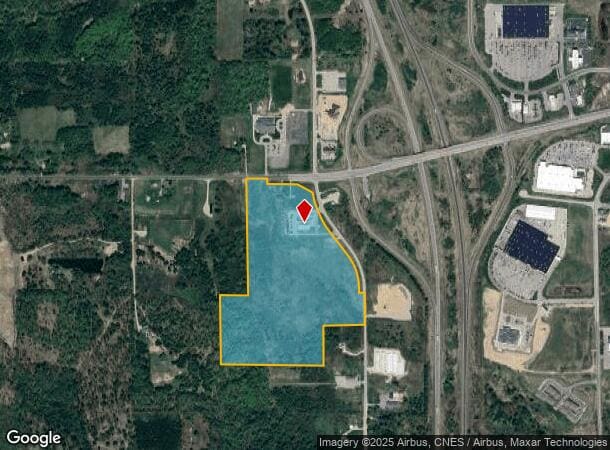
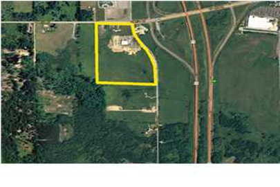
Property Record
14905 220Th Ave, Big Rapids, MI 49307

NEARBY LISTINGS FOR SALE OR LEASE
Property Detail
14905 220Th Ave
5405-020-001-200
SEC 20 T15N R10W BEG NE COR SEC 20; TH S 89 DEG 58 M W 1078.59 FT TO POB; TH S 89 DEG 58 M W 237.16 FT; TH S 0 DEG 45 DEG 28
Commercialnec
Mecosta
X
Michigan
26123C0250D
54.41 AC
2024
Michigan North Central Area
2025
Other Market Areas
960702
Big Rapids, MI
12,000 SF
DEMOGRAPHICS near 14905 220Th Ave
1 Mile
3 Mile
5 Mile
2024 Total Population
232
9,215
15,490
2029 Population
240
9,824
16,451
Pop Growth 2024-2029
+ 3.45%
+ 6.61%
+ 6.20%
Average Age
44
33
36
2024 Total Households
97
3,648
6,225
HH Growth 2024-2029
+ 4.12%
+ 7.32%
+ 6.57%
Median Household Inc
$59,999
$32,425
$40,875
Avg Household Size
2.30
2.10
2.20
2024 Avg HH Vehicles
2.00
2.00
2.00
Median Home Value
$217,647
$167,932
$160,114
Median Year Built
1984
1977
1979
Nearby Places
Map Layers
Map Styles
 Street
 Aerial
- Restaurants
- Banks
- Shops
- Fitness
- Groceries
Nearby Properties
Address
Land Use
TOTAL SIZE
Lot Size
Zoning
Address
Land Use
TOTAL SIZE
Lot Size
Zoning
56.64 AC
Address
Land Use
TOTAL SIZE
Lot Size
Zoning
205,711 SF
30.37 AC
Address
Land Use
TOTAL SIZE
Lot Size
Zoning
16.08 AC
Address
Land Use
TOTAL SIZE
Lot Size
Zoning
20,760 SF
36.80 AC
Address
Land Use
TOTAL SIZE
Lot Size
Zoning
95,044 SF
12.16 AC
Address
Land Use
TOTAL SIZE
Lot Size
Zoning
9.65 AC
Address
Land Use
TOTAL SIZE
Lot Size
Zoning
29.09 AC
Address
Land Use
TOTAL SIZE
Lot Size
Zoning
Address
Land Use
TOTAL SIZE
Lot Size
Zoning
23,240 SF
7.41 AC
Address
Land Use
TOTAL SIZE
Lot Size
Zoning
18,387 SF
6.21 AC
Address
Land Use
TOTAL SIZE
Lot Size
Zoning
10,080 SF
18.85 AC
Address
Land Use
TOTAL SIZE
Lot Size
Zoning
10,443 SF
5.81 AC
Address
Land Use
TOTAL SIZE
Lot Size
Zoning
14.05 AC
Address
Land Use
TOTAL SIZE
Lot Size
Zoning
60,416 SF
5.40 AC
Address
Land Use
TOTAL SIZE
Lot Size
Zoning
89,079 SF
6.90 AC
Address
Land Use
TOTAL SIZE
Lot Size
Zoning
14,094 SF
9.43 AC
Address
Land Use
TOTAL SIZE
Lot Size
Zoning
35.44 AC
Address
Land Use
TOTAL SIZE
Lot Size
Zoning
Address
Land Use
TOTAL SIZE
Lot Size
Zoning
Address
Land Use
TOTAL SIZE
Lot Size
Zoning
11,319 SF
3.41 AC
Address
Land Use
TOTAL SIZE
Lot Size
Zoning
12.54 AC
Address
Land Use
TOTAL SIZE
Lot Size
Zoning
25,434 SF
4.39 AC
Address
Land Use
TOTAL SIZE
Lot Size
Zoning
12,960 SF
6.14 AC
Address
Land Use
TOTAL SIZE
Lot Size
Zoning
20,300 SF
6.36 AC
Address
Land Use
TOTAL SIZE
Lot Size
Zoning
39,316 SF
3.54 AC
Address
Land Use
TOTAL SIZE
Lot Size
Zoning
26,520 SF
2.11 AC
Address
Land Use
TOTAL SIZE
Lot Size
Zoning
36,322 SF
3.22 AC
Address
Land Use
TOTAL SIZE
Lot Size
Zoning
13,650 SF
1.84 AC
Address
Land Use
TOTAL SIZE
Lot Size
Zoning
28,906 SF
2.56 AC
Address
Land Use
TOTAL SIZE
Lot Size
Zoning
24,088 SF
2.36 AC
The World's #1 Commercial Real Estate Marketplace
Connect with us
© 2026 CoStar Group
The information above has been obtained from sources believed reliable. While we do not doubt its accuracy we have not verified it and make no guarantee, warranty or representation about it. It is your responsibility to independently confirm its accuracy and completeness. Any projections, opinions, assumptions, or estimates used are for example only and do not represent the current or future performance of the property. The value of this transaction to you depends on tax and other factors which should be evaluated by your tax, financial, and legal advisors. You and your advisors should conduct a careful, independent investigation of the property to determine to your satisfaction the suitability of the property for your needs.