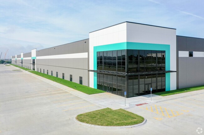
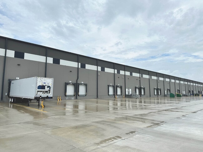
Property Record
14910 Gold Coast Rd, Papillion, NE 68046

NEARBY LISTINGS FOR SALE OR LEASE
Property Detail
14910 Gold Coast Rd
Omaha/Council Bluffs
R & R Commerce Park
Omaha-Council Bluffs, NE-IA
LOT 4 R & R COMMERCE PARK (16.57 AC)
011609522
Sarpy
Industrialgeneral
Nebraska
X
4
31153C0068H
16.57 AC
2024
Sarpy West
2025
DEMOGRAPHICS near 14910 Gold Coast Rd
1 Mile
3 Mile
5 Mile
2024 Total Population
7
20,864
102,052
2029 Population
7
22,761
108,107
Pop Growth 2024-2029
0.00%
+ 9.09%
+ 5.93%
Average Age
31
36
37
2024 Total Households
2
7,660
36,759
HH Growth 2024-2029
+ 50.00%
+ 9.33%
+ 5.96%
Median Household Inc
$87,500
$99,228
$104,014
Avg Household Size
2.00
2.70
2.70
2024 Avg HH Vehicles
2.00
2.00
2.00
Median Home Value
$750,000
$301,759
$274,108
Median Year Built
1979
2004
1999
Nearby Places
Map Layers
Map Styles
 Street
 Aerial
- Restaurants
- Banks
- Shops
- Fitness
- Groceries
PUBLIC TRANSPORTATION
AIRPORT
Eppley Airfield
DRIVE
WALK
Distance
Eppley Airfield
33 min
21.3 mi
Freight Ports
Tulsa Port Of Catoosa
DRIVE
WALK
Distance
Tulsa Port Of Catoosa
470 min
421.3 mi
SALE & LEASE HISTORY
LISTING DATE
SALE/LEASE

Sep 15, 2021
For Lease
Jul 12, 2024
For Lease
Nearby Properties
Address
Land Use
TOTAL SIZE
Lot Size
Zoning
Address
Land Use
TOTAL SIZE
Lot Size
Zoning
181,712 SF
131.75 AC
Address
Land Use
TOTAL SIZE
Lot Size
Zoning
94.11 AC
Address
Land Use
TOTAL SIZE
Lot Size
Zoning
1,831 SF
173.14 AC
Address
Land Use
TOTAL SIZE
Lot Size
Zoning
2,400 SF
21.27 AC
Address
Land Use
TOTAL SIZE
Lot Size
Zoning
51.65 AC
Address
Land Use
TOTAL SIZE
Lot Size
Zoning
543,301 SF
2.30 AC
IL
Address
Land Use
TOTAL SIZE
Lot Size
Zoning
48.50 AC
Address
Land Use
TOTAL SIZE
Lot Size
Zoning
315,685 SF
21.57 AC
RG10
Address
Land Use
TOTAL SIZE
Lot Size
Zoning
56,174 SF
8.65 AC
Address
Land Use
TOTAL SIZE
Lot Size
Zoning
9,600 SF
2.07 AC
IL
Address
Land Use
TOTAL SIZE
Lot Size
Zoning
8.10 AC
Address
Land Use
TOTAL SIZE
Lot Size
Zoning
23.99 AC
Address
Land Use
TOTAL SIZE
Lot Size
Zoning
334,533 SF
23.32 AC
Address
Land Use
TOTAL SIZE
Lot Size
Zoning
17.40 AC
Address
Land Use
TOTAL SIZE
Lot Size
Zoning
22.05 AC
Address
Land Use
TOTAL SIZE
Lot Size
Zoning
24,294 SF
25.79 AC
Address
Land Use
TOTAL SIZE
Lot Size
Zoning
183,184 SF
20.66 AC
Address
Land Use
TOTAL SIZE
Lot Size
Zoning
2,295 SF
11.77 AC
Address
Land Use
TOTAL SIZE
Lot Size
Zoning
27,027 SF
11.15 AC
Address
Land Use
TOTAL SIZE
Lot Size
Zoning
240,122 SF
10.16 AC
Address
Land Use
TOTAL SIZE
Lot Size
Zoning
210,585 SF
142.28 AC
I2
Address
Land Use
TOTAL SIZE
Lot Size
Zoning
250,999 SF
17.10 AC
Address
Land Use
TOTAL SIZE
Lot Size
Zoning
250,999 SF
15.44 AC
Address
Land Use
TOTAL SIZE
Lot Size
Zoning
6,210 SF
8.28 AC
Address
Land Use
TOTAL SIZE
Lot Size
Zoning
120,500 SF
12.05 AC
IL
Address
Land Use
TOTAL SIZE
Lot Size
Zoning
12,720 SF
3.44 AC
IL
Address
Land Use
TOTAL SIZE
Lot Size
Zoning
20.66 AC
Address
Land Use
TOTAL SIZE
Lot Size
Zoning
8,649 SF
17.76 AC
Address
Land Use
TOTAL SIZE
Lot Size
Zoning
170,760 SF
10.30 AC
RG10
The World's #1 Commercial Real Estate Marketplace
Connect with us
© 2026 CoStar Group
The information above has been obtained from sources believed reliable. While we do not doubt its accuracy we have not verified it and make no guarantee, warranty or representation about it. It is your responsibility to independently confirm its accuracy and completeness. Any projections, opinions, assumptions, or estimates used are for example only and do not represent the current or future performance of the property. The value of this transaction to you depends on tax and other factors which should be evaluated by your tax, financial, and legal advisors. You and your advisors should conduct a careful, independent investigation of the property to determine to your satisfaction the suitability of the property for your needs.