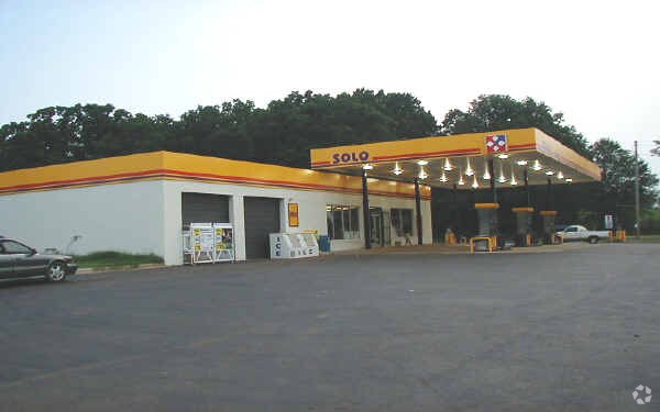
Property Record
14910 Nc 73 Hwy, Huntersville, NC 28078


NEARBY LISTINGS FOR SALE OR LEASE
Property Detail
14910 Nc 73 Hwy
Charlotte-Concord-Gastonia, NC-SC
Mdhb Propertie Llc
009-021-02
SEE 902102
Servicestation
Mecklenburg
X
North Carolina
3710462100K
2
2024
1.77 AC
2025
North
006210
Charlotte
4,163 SF
DEMOGRAPHICS near 14910 Nc 73 Hwy
1 Mile
3 Mile
5 Mile
2024 Total Population
2,359
32,873
85,153
2029 Population
2,480
34,669
90,781
Pop Growth 2024-2029
+ 5.13%
+ 5.46%
+ 6.61%
Average Age
38
39
40
2024 Total Households
841
12,763
33,492
HH Growth 2024-2029
+ 5.23%
+ 5.55%
+ 6.69%
Median Household Inc
$131,866
$114,568
$105,313
Avg Household Size
2.80
2.50
2.50
2024 Avg HH Vehicles
2.00
2.00
2.00
Median Home Value
$431,862
$381,678
$383,373
Median Year Built
2006
2000
2001
Nearby Places
Map Layers
Map Styles
 Street
 Aerial
- Restaurants
- Banks
- Shops
- Fitness
- Groceries
PUBLIC TRANSPORTATION
AIRPORT
Concord-Padgett Regional
DRIVE
WALK
Distance
Concord-Padgett Regional
27 min
17.3 mi
Charlotte/Douglas International
DRIVE
WALK
Distance
Charlotte/Douglas International
38 min
25.3 mi
Nearby Properties
Address
Land Use
TOTAL SIZE
Lot Size
Zoning
Address
Land Use
TOTAL SIZE
Lot Size
Zoning
525,296 SF
289.50 AC
SP
Address
Land Use
TOTAL SIZE
Lot Size
Zoning
395,706 SF
23.38 AC
NRCD
Address
Land Use
TOTAL SIZE
Lot Size
Zoning
280,344 SF
21.36 AC
NRCD
Address
Land Use
TOTAL SIZE
Lot Size
Zoning
339,268 SF
21.80 AC
NR
Address
Land Use
TOTAL SIZE
Lot Size
Zoning
292,144 SF
25.33 AC
NRCD
Address
Land Use
TOTAL SIZE
Lot Size
Zoning
200,768 SF
3.86 AC
HCCD
Address
Land Use
TOTAL SIZE
Lot Size
Zoning
202,245 SF
14.55 AC
NRCD
Address
Land Use
TOTAL SIZE
Lot Size
Zoning
120,661 SF
10.50 AC
HC(CD)
Address
Land Use
TOTAL SIZE
Lot Size
Zoning
204,216 SF
3.29 AC
HCCD
Address
Land Use
TOTAL SIZE
Lot Size
Zoning
180,542 SF
3.50 AC
HCCD
Address
Land Use
TOTAL SIZE
Lot Size
Zoning
Address
Land Use
TOTAL SIZE
Lot Size
Zoning
233,162 SF
61 AC
R
Address
Land Use
TOTAL SIZE
Lot Size
Zoning
62,877 SF
68 AC
CI
Address
Land Use
TOTAL SIZE
Lot Size
Zoning
127,743 SF
3.95 AC
VC(CD)
Address
Land Use
TOTAL SIZE
Lot Size
Zoning
142,710 SF
2.11 AC
HCCD
Address
Land Use
TOTAL SIZE
Lot Size
Zoning
72,114 SF
8.50 AC
HCCD
Address
Land Use
TOTAL SIZE
Lot Size
Zoning
22,344 SF
488.14 AC
R
Address
Land Use
TOTAL SIZE
Lot Size
Zoning
86,770 SF
71.85 AC
NR
Address
Land Use
TOTAL SIZE
Lot Size
Zoning
87,793 SF
17 AC
NR
Address
Land Use
TOTAL SIZE
Lot Size
Zoning
61,062 SF
8.77 AC
HCCD
Address
Land Use
TOTAL SIZE
Lot Size
Zoning
94,754 SF
18.48 AC
HC
Address
Land Use
TOTAL SIZE
Lot Size
Zoning
84,562 SF
6.09 AC
NR
Address
Land Use
TOTAL SIZE
Lot Size
Zoning
48,072 SF
5 AC
HC(CD)
Address
Land Use
TOTAL SIZE
Lot Size
Zoning
75,357 SF
2.56 AC
VC(CD)
Address
Land Use
TOTAL SIZE
Lot Size
Zoning
59,156 SF
5.99 AC
NR
Address
Land Use
TOTAL SIZE
Lot Size
Zoning
89,756 SF
4.83 AC
HCCD
Address
Land Use
TOTAL SIZE
Lot Size
Zoning
70,272 SF
2.03 AC
NR(CD)
Address
Land Use
TOTAL SIZE
Lot Size
Zoning
48,848 SF
14.40 AC
HC(CD)
Address
Land Use
TOTAL SIZE
Lot Size
Zoning
82,167 SF
9.21 AC
Address
Land Use
TOTAL SIZE
Lot Size
Zoning
51,471 SF
10.88 AC
GR
The World's #1 Commercial Real Estate Marketplace
Connect with us
© 2026 CoStar Group
The information above has been obtained from sources believed reliable. While we do not doubt its accuracy we have not verified it and make no guarantee, warranty or representation about it. It is your responsibility to independently confirm its accuracy and completeness. Any projections, opinions, assumptions, or estimates used are for example only and do not represent the current or future performance of the property. The value of this transaction to you depends on tax and other factors which should be evaluated by your tax, financial, and legal advisors. You and your advisors should conduct a careful, independent investigation of the property to determine to your satisfaction the suitability of the property for your needs.