Property Record
14911 S 27Th St, Bellevue, NE 68123
NEARBY LISTINGS FOR SALE OR LEASE
Property Detail
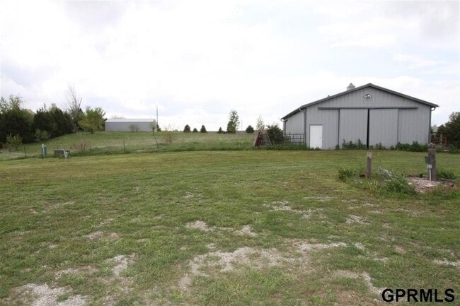
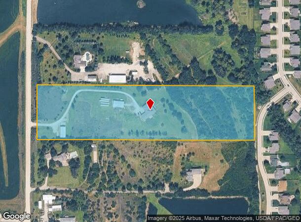
14911 S 27Th St
011223502
TAX LOT 2C 16-13-13 (9.77 AC)
Agriculturalland
Sarpy
X
Nebraska
31025C0125D
2c
2024
9.77 AC
2025
Southeast Omaha
010208
Omaha/Council Bluffs
7,442 SF
Omaha-Council Bluffs, NE-IA
DEMOGRAPHICS near 14911 S 27Th St
1 Mile
3 Mile
5 Mile
2024 Total Population
4,827
28,014
63,918
2029 Population
5,196
30,416
69,168
Pop Growth 2024-2029
+ 7.64%
+ 8.57%
+ 8.21%
Average Age
35
35
37
2024 Total Households
1,739
9,953
24,262
HH Growth 2024-2029
+ 7.88%
+ 8.64%
+ 8.32%
Median Household Inc
$114,128
$95,132
$77,977
Avg Household Size
2.80
2.80
2.60
2024 Avg HH Vehicles
2.00
2.00
2.00
Median Home Value
$278,774
$265,997
$255,616
Median Year Built
2004
1997
1993
Nearby Places
Map Layers
Map Styles
 Street
 Aerial
- Restaurants
- Banks
- Shops
- Fitness
- Groceries
PUBLIC TRANSPORTATION
AIRPORT
Eppley Airfield
DRIVE
WALK
Distance
Eppley Airfield
30 min
17.9 mi
Freight Ports
Tulsa Port Of Catoosa
DRIVE
WALK
Distance
Tulsa Port Of Catoosa
450 min
407.3 mi
Nearby Properties
Address
Land Use
TOTAL SIZE
Lot Size
Zoning
Address
Land Use
TOTAL SIZE
Lot Size
Zoning
24,969 SF
3.79 AC
RG20
Address
Land Use
TOTAL SIZE
Lot Size
Zoning
143 SF
17.56 AC
RG28
Address
Land Use
TOTAL SIZE
Lot Size
Zoning
10,800 SF
12.03 AC
Address
Land Use
TOTAL SIZE
Lot Size
Zoning
2,440 SF
18.88 AC
RG28
Address
Land Use
TOTAL SIZE
Lot Size
Zoning
121,660 SF
9.23 AC
RG28
Address
Land Use
TOTAL SIZE
Lot Size
Zoning
141,620 SF
84.13 AC
ILM
Address
Land Use
TOTAL SIZE
Lot Size
Zoning
331 SF
7.35 AC
Address
Land Use
TOTAL SIZE
Lot Size
Zoning
136,462 SF
9.66 AC
RG20
Address
Land Use
TOTAL SIZE
Lot Size
Zoning
Address
Land Use
TOTAL SIZE
Lot Size
Zoning
84,711 SF
10.45 AC
RG28
Address
Land Use
TOTAL SIZE
Lot Size
Zoning
101,606 SF
5.01 AC
RG20
Address
Land Use
TOTAL SIZE
Lot Size
Zoning
42,464 SF
6.66 AC
Address
Land Use
TOTAL SIZE
Lot Size
Zoning
19.78 AC
RG20
Address
Land Use
TOTAL SIZE
Lot Size
Zoning
38,586 SF
2.80 AC
Address
Land Use
TOTAL SIZE
Lot Size
Zoning
15,634 SF
19.60 AC
Address
Land Use
TOTAL SIZE
Lot Size
Zoning
4.75 AC
IGM
Address
Land Use
TOTAL SIZE
Lot Size
Zoning
18,093 SF
2.06 AC
BGC
Address
Land Use
TOTAL SIZE
Lot Size
Zoning
5,400 SF
0.80 AC
MH
Address
Land Use
TOTAL SIZE
Lot Size
Zoning
43.33 AC
RD50
Address
Land Use
TOTAL SIZE
Lot Size
Zoning
12.62 AC
AG
Address
Land Use
TOTAL SIZE
Lot Size
Zoning
11,989 SF
9.62 AC
Address
Land Use
TOTAL SIZE
Lot Size
Zoning
6,371 SF
3.49 AC
RG20
Address
Land Use
TOTAL SIZE
Lot Size
Zoning
1,152 SF
319.20 AC
AG
Address
Land Use
TOTAL SIZE
Lot Size
Zoning
5,001 SF
4.91 AC
Address
Land Use
TOTAL SIZE
Lot Size
Zoning
304.68 AC
AG
Address
Land Use
TOTAL SIZE
Lot Size
Zoning
58,528 SF
4.58 AC
BGH
Address
Land Use
TOTAL SIZE
Lot Size
Zoning
14,758 SF
43.38 AC
AG
Address
Land Use
TOTAL SIZE
Lot Size
Zoning
48,677 SF
0.74 AC
IL
Address
Land Use
TOTAL SIZE
Lot Size
Zoning
8,225 SF
11.99 AC
IL
The World's #1 Commercial Real Estate Marketplace
Connect with us
© 2026 CoStar Group
The information above has been obtained from sources believed reliable. While we do not doubt its accuracy we have not verified it and make no guarantee, warranty or representation about it. It is your responsibility to independently confirm its accuracy and completeness. Any projections, opinions, assumptions, or estimates used are for example only and do not represent the current or future performance of the property. The value of this transaction to you depends on tax and other factors which should be evaluated by your tax, financial, and legal advisors. You and your advisors should conduct a careful, independent investigation of the property to determine to your satisfaction the suitability of the property for your needs.