Property Record
15200 Mattawoman Dr, Brandywine, MD 20613


Save to a Folder
{{folder.Name}}
{{folder.ListingIds.length}} Properties
{{folder.ListingIds.length}} Property
Create a New Folder
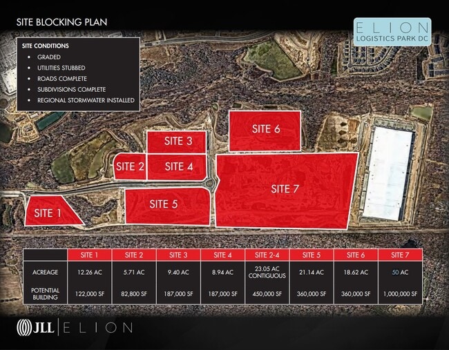
This Property Is For Sale
Property Detail
15200 Mattawoman Dr
11-5705221
PLAT 3 PARCEL D
Commercialnec
PRINCE GEORGE'S
IH
Maryland
B and X Area of moderate flood hazard, usually the area between the limits of the 100-year and 500-year floods.
98.41 AC
2024
Outlying PG County South
2025
Washington, DC
801003
Washington-Arlington-Alexandria, DC-VA-MD-WV
NEARBY LISTINGS FOR SALE OR LEASE
DEMOGRAPHICS near 15200 Mattawoman Dr
1 mile
3 mile
5 mile
2025 Total Population
2,189
18,993
52,574
2030 Population
2,471
19,970
54,421
Pop Growth 2025-2030
+ 12.88%
+ 5.14%
+ 3.51%
Average Age
46
42
41
2025 Total Households
899
6,769
18,485
HH Growth 2025-2030
+ 13.01%
+ 5.45%
+ 3.69%
Median Household Inc
$119,951
$126,745
$119,324
Avg Household Size
2.40
2.70
2.80
2025 Avg HH Vehicles
2.00
2.00
2.00
Median Home Value
$485,566
$465,312
$440,378
Median Year Built
2010
1997
1992
Nearby Places
Map Layers
Map Styles
 Street
 Aerial
Layers
 Traffic
 Biking
Places
Listings with unknown addresses are not visible on the map
- Restaurants
- Banks
- Shops
- Fitness
- Groceries
PUBLIC TRANSPORTATION
AIRPORT
Ronald Reagan Washington Ntl
Drive
Walk
Distance
Ronald Reagan Washington Ntl
41 min
24.5 mi
Freight Ports
Port of Baltimore
Drive
Walk
Distance
Port of Baltimore
76 min
51.3 mi
Nearby Properties
Address
Land Use
TOTAL SIZE
Lot Size
Zoning
Address
Land Use
TOTAL SIZE
Lot Size
Zoning
801,684 SF
34.05 AC
IE
Address
Land Use
TOTAL SIZE
Lot Size
Zoning
7,670 SF
9.78 AC
TACC
Address
Land Use
TOTAL SIZE
Lot Size
Zoning
392,898 SF
36.37 AC
PRD
Address
Land Use
TOTAL SIZE
Lot Size
Zoning
617,760 SF
25.75 AC
IE
Address
Land Use
TOTAL SIZE
Lot Size
Zoning
388,608 SF
28.45 AC
LCD
Address
Land Use
TOTAL SIZE
Lot Size
Zoning
76,906 SF
168.92 AC
AG
Address
Land Use
TOTAL SIZE
Lot Size
Zoning
126,592 SF
58.79 AC
ROS
Address
Land Use
TOTAL SIZE
Lot Size
Zoning
177,540 SF
27.64 AC
WCD
Address
Land Use
TOTAL SIZE
Lot Size
Zoning
177,540 SF
12.66 AC
WCD
Address
Land Use
TOTAL SIZE
Lot Size
Zoning
167,075 SF
11.01 AC
RH
Address
Land Use
TOTAL SIZE
Lot Size
Zoning
156,118 SF
17.01 AC
TACE
Address
Land Use
TOTAL SIZE
Lot Size
Zoning
62,838 SF
7.77 AC
TACE
Address
Land Use
TOTAL SIZE
Lot Size
Zoning
161,208 SF
10.99 AC
RH
Address
Land Use
TOTAL SIZE
Lot Size
Zoning
67,608 SF
4.01 AC
TACC
Address
Land Use
TOTAL SIZE
Lot Size
Zoning
61,836 SF
9.63 AC
IE
Address
Land Use
TOTAL SIZE
Lot Size
Zoning
132,745 SF
2.59 AC
CC
Address
Land Use
TOTAL SIZE
Lot Size
Zoning
1,592.32 AC
ROS
Address
Land Use
TOTAL SIZE
Lot Size
Zoning
54,899 SF
5.23 AC
TACE
Address
Land Use
TOTAL SIZE
Lot Size
Zoning
128,909 SF
10.77 AC
TACE
Address
Land Use
TOTAL SIZE
Lot Size
Zoning
62,442 SF
4.84 AC
TACE
Address
Land Use
TOTAL SIZE
Lot Size
Zoning
28,508 SF
10 AC
TACC
Address
Land Use
TOTAL SIZE
Lot Size
Zoning
80,760 SF
5.70 AC
CC
Address
Land Use
TOTAL SIZE
Lot Size
Zoning
61,125 SF
10.10 AC
TACE
Address
Land Use
TOTAL SIZE
Lot Size
Zoning
80,922 SF
9.58 AC
PRD
Address
Land Use
TOTAL SIZE
Lot Size
Zoning
72,873 SF
8.05 AC
AUC
Address
Land Use
TOTAL SIZE
Lot Size
Zoning
2,160 SF
125.75 AC
AG
Address
Land Use
TOTAL SIZE
Lot Size
Zoning
127,206 SF
2.90 AC
TACE
Address
Land Use
TOTAL SIZE
Lot Size
Zoning
65,400 SF
4.41 AC
RH
Address
Land Use
TOTAL SIZE
Lot Size
Zoning
119,393 SF
12.21 AC
CC
The World's #1 Commercial Real Estate Marketplace
Connect with us
© 2026 CoStar Group
The information above has been obtained from sources believed reliable. While we do not doubt its accuracy we have not verified it and make no guarantee, warranty or representation about it. It is your responsibility to independently confirm its accuracy and completeness. Any projections, opinions, assumptions, or estimates used are for example only and do not represent the current or future performance of the property. The value of this transaction to you depends on tax and other factors which should be evaluated by your tax, financial, and legal advisors. You and your advisors should conduct a careful, independent investigation of the property to determine to your satisfaction the suitability of the property for your needs.