Property Record
14915 S 49Th West Ave, Kiefer, OK 74041
NEARBY LISTINGS FOR SALE OR LEASE
Property Detail
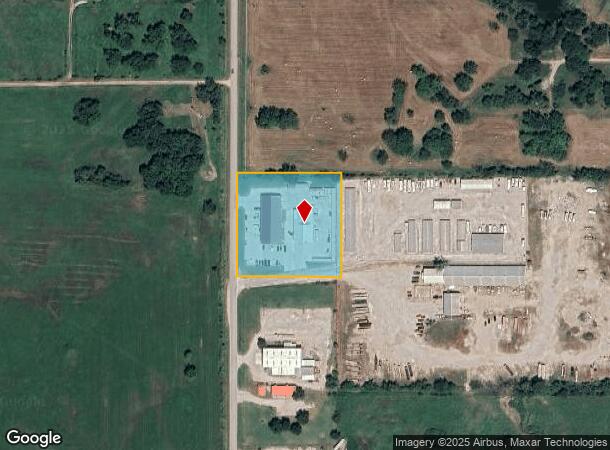
14915 S 49Th West Ave
Tulsa, OK
Unplatted Kiefer
7917-16-017-012-0-006-00
16-17-12 TRACT BEG NW COR N SW SW TH E330 S330 W330 N330 TO POB
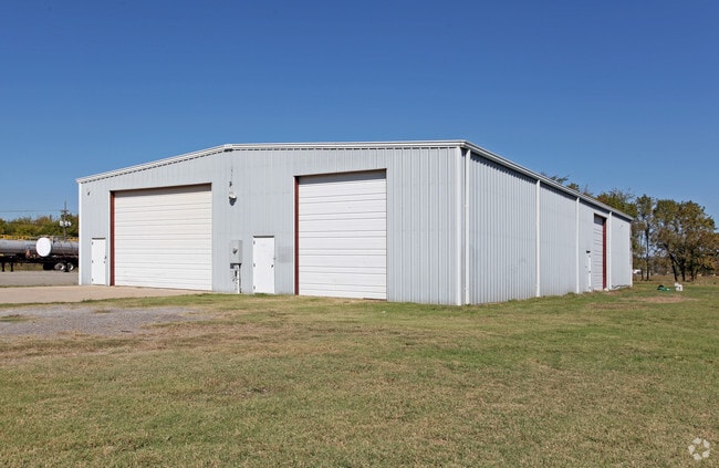
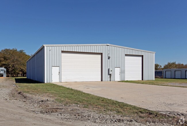
Warehouse
Creek
X
Oklahoma
40037C0310D
12
2024
2.49 AC
2025
Creek County
021500
Tulsa
6,000 SF
DEMOGRAPHICS near 14915 S 49Th West Ave
1 Mile
3 Mile
5 Mile
2024 Total Population
1,712
11,313
48,528
2029 Population
1,756
11,621
50,330
Pop Growth 2024-2029
+ 2.57%
+ 2.72%
+ 3.71%
Average Age
38
37
37
2024 Total Households
593
4,057
17,386
HH Growth 2024-2029
+ 2.36%
+ 2.76%
+ 3.83%
Median Household Inc
$83,848
$72,134
$70,698
Avg Household Size
2.90
2.80
2.70
2024 Avg HH Vehicles
2.00
2.00
2.00
Median Home Value
$189,999
$186,264
$199,608
Median Year Built
2002
1994
1992
Nearby Places
Map Layers
Map Styles
 Street
 Aerial
- Restaurants
- Banks
- Shops
- Fitness
- Groceries
PUBLIC TRANSPORTATION
AIRPORT
Tulsa International
DRIVE
WALK
Distance
Tulsa International
36 min
25.9 mi
Freight Ports
Tulsa Port Of Catoosa
DRIVE
WALK
Distance
Tulsa Port Of Catoosa
45 min
34.6 mi
Nearby Properties
Address
Land Use
TOTAL SIZE
Lot Size
Zoning
Address
Land Use
TOTAL SIZE
Lot Size
Zoning
58,907 SF
5 AC
CG
Address
Land Use
TOTAL SIZE
Lot Size
Zoning
49,735 SF
14.35 AC
CG
Address
Land Use
TOTAL SIZE
Lot Size
Zoning
116,016 SF
54.80 AC
CG
Address
Land Use
TOTAL SIZE
Lot Size
Zoning
28,761 SF
9.71 AC
RS1
Address
Land Use
TOTAL SIZE
Lot Size
Zoning
331,125 SF
17.64 AC
CG
Address
Land Use
TOTAL SIZE
Lot Size
Zoning
6,702 SF
3.63 AC
AG
Address
Land Use
TOTAL SIZE
Lot Size
Zoning
23,600 SF
15.69 AC
Address
Land Use
TOTAL SIZE
Lot Size
Zoning
38,476 SF
18.68 AC
CG
Address
Land Use
TOTAL SIZE
Lot Size
Zoning
68,298 SF
28.61 AC
CG
Address
Land Use
TOTAL SIZE
Lot Size
Zoning
27.87 AC
IM
Address
Land Use
TOTAL SIZE
Lot Size
Zoning
22.20 AC
AG
Address
Land Use
TOTAL SIZE
Lot Size
Zoning
16,068 SF
0.80 AC
CG
Address
Land Use
TOTAL SIZE
Lot Size
Zoning
32,408 SF
6.25 AC
AG
Address
Land Use
TOTAL SIZE
Lot Size
Zoning
5,920 SF
7.67 AC
AG
Address
Land Use
TOTAL SIZE
Lot Size
Zoning
27,910 SF
2.54 AC
CG
Address
Land Use
TOTAL SIZE
Lot Size
Zoning
36.56 AC
AG
Address
Land Use
TOTAL SIZE
Lot Size
Zoning
33,128 SF
1.83 AC
RM2
Address
Land Use
TOTAL SIZE
Lot Size
Zoning
107,943 SF
8.49 AC
PUD
Address
Land Use
TOTAL SIZE
Lot Size
Zoning
57,534 SF
1.73 AC
CG
Address
Land Use
TOTAL SIZE
Lot Size
Zoning
5,075 SF
1.45 AC
CS
Address
Land Use
TOTAL SIZE
Lot Size
Zoning
9,950 SF
4.76 AC
RS2
Address
Land Use
TOTAL SIZE
Lot Size
Zoning
197,644 SF
32.39 AC
IL
Address
Land Use
TOTAL SIZE
Lot Size
Zoning
2,400 SF
19.62 AC
Address
Land Use
TOTAL SIZE
Lot Size
Zoning
6.76 AC
AG
Address
Land Use
TOTAL SIZE
Lot Size
Zoning
16,000 SF
1.07 AC
IL
Address
Land Use
TOTAL SIZE
Lot Size
Zoning
7,340 SF
0.24 AC
RS3
Address
Land Use
TOTAL SIZE
Lot Size
Zoning
840 SF
10.43 AC
AG
Address
Land Use
TOTAL SIZE
Lot Size
Zoning
5,800 SF
1.86 AC
CS
The World's #1 Commercial Real Estate Marketplace
Connect with us
© 2026 CoStar Group
The information above has been obtained from sources believed reliable. While we do not doubt its accuracy we have not verified it and make no guarantee, warranty or representation about it. It is your responsibility to independently confirm its accuracy and completeness. Any projections, opinions, assumptions, or estimates used are for example only and do not represent the current or future performance of the property. The value of this transaction to you depends on tax and other factors which should be evaluated by your tax, financial, and legal advisors. You and your advisors should conduct a careful, independent investigation of the property to determine to your satisfaction the suitability of the property for your needs.