Property Record
14924 Beloit Snodes Rd, Beloit, OH 44609
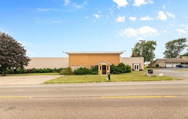


This Property Is For Sale
Property Detail
14924 Beloit Snodes Rd
Youngstown-Warren, OH
LOT 14 284.48 X 670.13 IRR COMMUNITY BIBLE CHURCH PLAT NO 1
16-058-0-021.00-0
MAHONING
Warehouse
Ohio
2025
14
2025
3.32 AC
813000
Mahoning County
12,182 SF
Youngstown/Warren/Boardman
NEARBY LISTINGS FOR SALE OR LEASE
-
-
View all Beloit listings for sale on LoopNet.com
DEMOGRAPHICS near 14924 Beloit Snodes Rd
1 mile
3 mile
5 mile
2025 Total Population
779
8,842
13,336
2030 Population
762
8,826
13,257
Pop Growth 2025-2030
(2.18%)
(0.18%)
(0.59%)
Average Age
44
46
45
2025 Total Households
318
3,865
5,689
HH Growth 2025-2030
(2.20%)
+ 0.10%
(0.37%)
Median Household Inc
$66,982
$54,012
$58,915
Avg Household Size
2.40
2.20
2.30
2025 Avg HH Vehicles
2.00
2.00
2.00
Median Home Value
$205,422
$144,171
$154,169
Median Year Built
1956
1956
1957
Nearby Places
Map Layers
Map Styles
 Street
 Aerial
Layers
 Traffic
 Biking
Places
Listings with unknown addresses are not visible on the map
- Restaurants
- Banks
- Shops
- Fitness
- Groceries
PUBLIC TRANSPORTATION
COMMUTER RAIL
Alliance Amtrak (Capitol Limited - Amtrak)
Drive
Walk
Distance
Alliance Amtrak (Capitol Limited - Amtrak)
11 min
6.6 mi
AIRPORT
Akron-Canton Regional
Drive
Walk
Distance
Akron-Canton Regional
42 min
25.2 mi
Freight Ports
Port of Toledo
Drive
Walk
Distance
Port of Toledo
201 min
162.8 mi
Nearby Properties
Address
Land Use
TOTAL SIZE
Lot Size
Zoning
Address
Land Use
TOTAL SIZE
Lot Size
Zoning
414,392 SF
173.14 AC
Address
Land Use
TOTAL SIZE
Lot Size
Zoning
163,371 SF
46.01 AC
Address
Land Use
TOTAL SIZE
Lot Size
Zoning
122,627 SF
32.94 AC
Address
Land Use
TOTAL SIZE
Lot Size
Zoning
Address
Land Use
TOTAL SIZE
Lot Size
Zoning
181,049 SF
173.14 AC
Address
Land Use
TOTAL SIZE
Lot Size
Zoning
146,378 SF
28.72 AC
Address
Land Use
TOTAL SIZE
Lot Size
Zoning
85,650 SF
5.62 AC
Address
Land Use
TOTAL SIZE
Lot Size
Zoning
54,218 SF
2.28 AC
Address
Land Use
TOTAL SIZE
Lot Size
Zoning
107,879 SF
3.91 AC
Address
Land Use
TOTAL SIZE
Lot Size
Zoning
310,165 SF
16.97 AC
Address
Land Use
TOTAL SIZE
Lot Size
Zoning
126,620 SF
173.14 AC
Address
Land Use
TOTAL SIZE
Lot Size
Zoning
15,742 SF
1.25 AC
Address
Land Use
TOTAL SIZE
Lot Size
Zoning
Address
Land Use
TOTAL SIZE
Lot Size
Zoning
57,041 SF
5.66 AC
Address
Land Use
TOTAL SIZE
Lot Size
Zoning
63.77 AC
Address
Land Use
TOTAL SIZE
Lot Size
Zoning
125,868 SF
4.75 AC
Address
Land Use
TOTAL SIZE
Lot Size
Zoning
110,057 SF
6.20 AC
Address
Land Use
TOTAL SIZE
Lot Size
Zoning
62,916 SF
3.72 AC
Address
Land Use
TOTAL SIZE
Lot Size
Zoning
17,504 SF
6.50 AC
Address
Land Use
TOTAL SIZE
Lot Size
Zoning
4,776 SF
74.40 AC
Address
Land Use
TOTAL SIZE
Lot Size
Zoning
6,475 SF
14.09 AC
Address
Land Use
TOTAL SIZE
Lot Size
Zoning
40,200 SF
3.02 AC
Address
Land Use
TOTAL SIZE
Lot Size
Zoning
23,142 SF
1.47 AC
Address
Land Use
TOTAL SIZE
Lot Size
Zoning
18,269 SF
3.79 AC
Address
Land Use
TOTAL SIZE
Lot Size
Zoning
15,070 SF
6.25 AC
Address
Land Use
TOTAL SIZE
Lot Size
Zoning
2,360 SF
176.92 AC
Address
Land Use
TOTAL SIZE
Lot Size
Zoning
219.18 AC
Address
Land Use
TOTAL SIZE
Lot Size
Zoning
2,704 SF
142.98 AC
Address
Land Use
TOTAL SIZE
Lot Size
Zoning
12,692 SF
6.19 AC
Address
Land Use
TOTAL SIZE
Lot Size
Zoning
15,112 SF
6.64 AC
The World's #1 Commercial Real Estate Marketplace
Connect with us
© 2026 CoStar Group
The information above has been obtained from sources believed reliable. While we do not doubt its accuracy we have not verified it and make no guarantee, warranty or representation about it. It is your responsibility to independently confirm its accuracy and completeness. Any projections, opinions, assumptions, or estimates used are for example only and do not represent the current or future performance of the property. The value of this transaction to you depends on tax and other factors which should be evaluated by your tax, financial, and legal advisors. You and your advisors should conduct a careful, independent investigation of the property to determine to your satisfaction the suitability of the property for your needs.