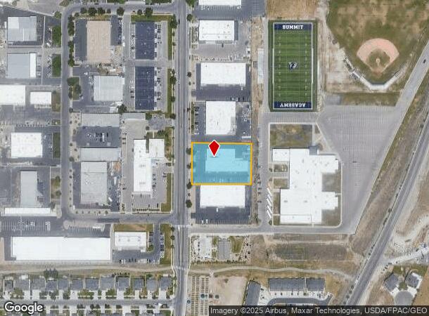
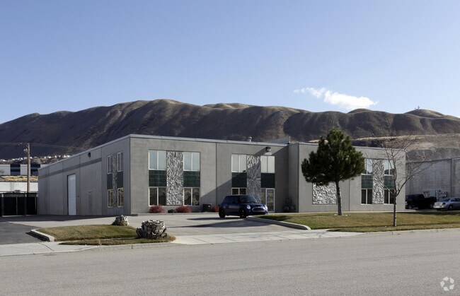
Property Record
14927 S Heritagecrest Way, Bluffdale, UT 84065

NEARBY LISTINGS FOR SALE OR LEASE
Property Detail
14927 S Heritagecrest Way
Salt Lake City, UT
Heritage Industrial Park
33-11-478-007-0000
LOT 304, HERITAGE INDUSTRIAL PARK PHASE 3 FINAL PLAT. 8283-7167
Multipleuses
Salt Lake
X
Utah
49035C0581H
304
2024
1 AC
2025
Riverton
112827
Salt Lake City
15,345 SF
DEMOGRAPHICS near 14927 S Heritagecrest Way
1 Mile
3 Mile
5 Mile
2024 Total Population
8,978
55,498
164,539
2029 Population
9,384
58,594
175,295
Pop Growth 2024-2029
+ 4.52%
+ 5.58%
+ 6.54%
Average Age
28
33
33
2024 Total Households
2,610
15,990
47,996
HH Growth 2024-2029
+ 4.41%
+ 5.73%
+ 6.48%
Median Household Inc
$96,529
$109,302
$114,809
Avg Household Size
3.50
3.30
3.30
2024 Avg HH Vehicles
2.00
2.00
2.00
Median Home Value
$578,068
$647,894
$623,328
Median Year Built
2011
2009
2007
Nearby Places
Map Layers
Map Styles
 Street
 Aerial
- Restaurants
- Banks
- Shops
- Fitness
- Groceries
PUBLIC TRANSPORTATION
COMMUTER RAIL
Draper Station (FrontRunner - Utah Transit Authority (UTA))
DRIVE
WALK
Distance
Draper Station (FrontRunner - Utah Transit Authority (UTA))
10 min
4.3 mi
Lehi Station (FrontRunner - Utah Transit Authority (UTA))
DRIVE
WALK
Distance
Lehi Station (FrontRunner - Utah Transit Authority (UTA))
11 min
6.3 mi
AIRPORT
Salt Lake City International
DRIVE
WALK
Distance
Salt Lake City International
32 min
26.0 mi
Provo Municipal
DRIVE
WALK
Distance
Provo Municipal
38 min
27.0 mi
Freight Ports
Port of Stockton
DRIVE
WALK
Distance
Port of Stockton
733 min
716.4 mi
Nearby Properties
Address
Land Use
TOTAL SIZE
Lot Size
Zoning
Address
Land Use
TOTAL SIZE
Lot Size
Zoning
161,466 SF
624.79 AC
M-1
Address
Land Use
TOTAL SIZE
Lot Size
Zoning
40,495 SF
33.28 AC
RM-1
Address
Land Use
TOTAL SIZE
Lot Size
Zoning
774,515 SF
87.50 AC
M-1
Address
Land Use
TOTAL SIZE
Lot Size
Zoning
423,208 SF
8.07 AC
CSD-H
Address
Land Use
TOTAL SIZE
Lot Size
Zoning
359,628 SF
4.53 AC
TSD
Address
Land Use
TOTAL SIZE
Lot Size
Zoning
187,621 SF
3.64 AC
1103
Address
Land Use
TOTAL SIZE
Lot Size
Zoning
99,144 SF
6.23 AC
HC
Address
Land Use
TOTAL SIZE
Lot Size
Zoning
65,664 SF
16.47 AC
RM2
Address
Land Use
TOTAL SIZE
Lot Size
Zoning
391,078 SF
5.78 AC
IC
Address
Land Use
TOTAL SIZE
Lot Size
Zoning
416,562 SF
7.48 AC
CSDDPM
Address
Land Use
TOTAL SIZE
Lot Size
Zoning
81,925 SF
10.13 AC
MU
Address
Land Use
TOTAL SIZE
Lot Size
Zoning
115,637 SF
36.38 AC
TSD
Address
Land Use
TOTAL SIZE
Lot Size
Zoning
374,097 SF
6.87 AC
CSDDPM
Address
Land Use
TOTAL SIZE
Lot Size
Zoning
130,809 SF
16.13 AC
RM 1
Address
Land Use
TOTAL SIZE
Lot Size
Zoning
247,899 SF
9.20 AC
TSD
Address
Land Use
TOTAL SIZE
Lot Size
Zoning
296,237 SF
6.45 AC
TSD
Address
Land Use
TOTAL SIZE
Lot Size
Zoning
353,500 SF
29.38 AC
CR
Address
Land Use
TOTAL SIZE
Lot Size
Zoning
255,090 SF
17.91 AC
CSDDRC
Address
Land Use
TOTAL SIZE
Lot Size
Zoning
408,208 SF
5.20 AC
DC
Address
Land Use
TOTAL SIZE
Lot Size
Zoning
76,420 SF
14.22 AC
RM-2
Address
Land Use
TOTAL SIZE
Lot Size
Zoning
249.04 AC
OS
Address
Land Use
TOTAL SIZE
Lot Size
Zoning
53,777 SF
229.36 AC
SF-1
Address
Land Use
TOTAL SIZE
Lot Size
Zoning
179,860 SF
11.50 AC
M-1
Address
Land Use
TOTAL SIZE
Lot Size
Zoning
193.06 AC
1115
Address
Land Use
TOTAL SIZE
Lot Size
Zoning
255,928 SF
14.90 AC
M-1
Address
Land Use
TOTAL SIZE
Lot Size
Zoning
207,380 SF
5.29 AC
CR
Address
Land Use
TOTAL SIZE
Lot Size
Zoning
186,398 SF
8.57 AC
CSD
Address
Land Use
TOTAL SIZE
Lot Size
Zoning
96,629 SF
14.43 AC
MU
Address
Land Use
TOTAL SIZE
Lot Size
Zoning
107,632 SF
6.50 AC
CSD
Address
Land Use
TOTAL SIZE
Lot Size
Zoning
70,379 SF
2.81 AC
RM2
The World's #1 Commercial Real Estate Marketplace
Connect with us
© 2025 CoStar Group
The information above has been obtained from sources believed reliable. While we do not doubt its accuracy we have not verified it and make no guarantee, warranty or representation about it. It is your responsibility to independently confirm its accuracy and completeness. Any projections, opinions, assumptions, or estimates used are for example only and do not represent the current or future performance of the property. The value of this transaction to you depends on tax and other factors which should be evaluated by your tax, financial, and legal advisors. You and your advisors should conduct a careful, independent investigation of the property to determine to your satisfaction the suitability of the property for your needs.