Property Record
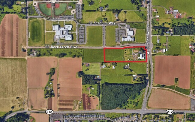
14933 Se 172Nd Ave, Clackamas, OR 97015


Property Detail
14933 Se 172Nd Ave
00614623
PARTITION PLAT 2019-101 PT PARCEL 4
Multifamilyacreage
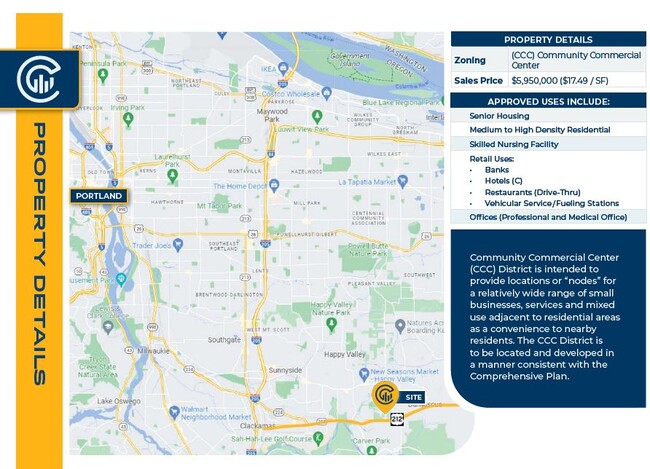
Clackamas
CCC
Oregon
B and X Area of moderate flood hazard, usually the area between the limits of the 100-year and 500-year floods.
1
2025
7.81 AC
2025
Clackamas/Milwaukie
023202
Portland
2,488 SF
Portland-Vancouver-Hillsboro, OR-WA
NEARBY LISTINGS FOR SALE OR LEASE
DEMOGRAPHICS near 14933 Se 172Nd Ave
1 mile
3 mile
5 mile
2025 Total Population
7,899
43,868
109,757
2030 Population
8,073
44,458
110,487
Pop Growth 2025-2030
+ 2.20%
+ 1.34%
+ 0.67%
Average Age
38
40
41
2025 Total Households
2,577
14,621
38,483
HH Growth 2025-2030
+ 2.17%
+ 1.29%
+ 0.56%
Median Household Inc
$109,965
$111,368
$102,410
Avg Household Size
3.00
2.90
2.80
2025 Avg HH Vehicles
2.00
2.00
2.00
Median Home Value
$686,277
$682,455
$667,437
Median Year Built
2003
1997
1992
Nearby Places
Map Layers
Map Styles
 Street
 Aerial
Layers
 Traffic
 Biking
Places
Listings with unknown addresses are not visible on the map
- Restaurants
- Banks
- Shops
- Fitness
- Groceries
PUBLIC TRANSPORTATION
COMMUTER RAIL
Oregon City Amtrak (Amtrak Cascades - Amtrak)
Drive
Walk
Distance
Oregon City Amtrak (Amtrak Cascades - Amtrak)
14 min
8.2 mi
AIRPORT
Portland International
Drive
Walk
Distance
Portland International
29 min
18.7 mi
Freight Ports
Port of Portland
Drive
Walk
Distance
Port of Portland
32 min
18.1 mi
SALE & LEASE HISTORY
LISTING DATE
SALE/LEASE

Sep 24, 2016
For Sale
Sep 21, 2022
For Sale
Oct 05, 2017
For Sale
Mar 23, 2022
For Sale
Aug 09, 2018
For Sale
Apr 03, 2020
For Sale
Nearby Properties
Address
Land Use
TOTAL SIZE
Lot Size
Zoning
Address
Land Use
TOTAL SIZE
Lot Size
Zoning
6.92 AC
MCC
Address
Land Use
TOTAL SIZE
Lot Size
Zoning
2,232 SF
15.74 AC
MUC
Address
Land Use
TOTAL SIZE
Lot Size
Zoning
12.06 AC
MCC
Address
Land Use
TOTAL SIZE
Lot Size
Zoning
9 AC
MUE
Address
Land Use
TOTAL SIZE
Lot Size
Zoning
22.99 AC
LI
Address
Land Use
TOTAL SIZE
Lot Size
Zoning
8 AC
MURM1
Address
Land Use
TOTAL SIZE
Lot Size
Zoning
2,089 SF
4.30 AC
MURM2
Address
Land Use
TOTAL SIZE
Lot Size
Zoning
6 AC
GI
Address
Land Use
TOTAL SIZE
Lot Size
Zoning
7.25 AC
LI
Address
Land Use
TOTAL SIZE
Lot Size
Zoning
3,342 SF
9.34 AC
MUE
Address
Land Use
TOTAL SIZE
Lot Size
Zoning
17.04 AC
GI
Address
Land Use
TOTAL SIZE
Lot Size
Zoning
2,510 SF
16.02 AC
GI
Address
Land Use
TOTAL SIZE
Lot Size
Zoning
4.83 AC
MCC
Address
Land Use
TOTAL SIZE
Lot Size
Zoning
5.66 AC
MCC
Address
Land Use
TOTAL SIZE
Lot Size
Zoning
1 AC
MURX
Address
Land Use
TOTAL SIZE
Lot Size
Zoning
5.52 AC
MURM1
Address
Land Use
TOTAL SIZE
Lot Size
Zoning
Address
Land Use
TOTAL SIZE
Lot Size
Zoning
14.44 AC
MR2
Address
Land Use
TOTAL SIZE
Lot Size
Zoning
1,386 SF
12.64 AC
GI
Address
Land Use
TOTAL SIZE
Lot Size
Zoning
3.15 AC
MURM2
Address
Land Use
TOTAL SIZE
Lot Size
Zoning
1,896 SF
1.96 AC
VO
Address
Land Use
TOTAL SIZE
Lot Size
Zoning
5.31 AC
C2
Address
Land Use
TOTAL SIZE
Lot Size
Zoning
Address
Land Use
TOTAL SIZE
Lot Size
Zoning
Address
Land Use
TOTAL SIZE
Lot Size
Zoning
Address
Land Use
TOTAL SIZE
Lot Size
Zoning
9 AC
LI
Address
Land Use
TOTAL SIZE
Lot Size
Zoning
6.60 AC
LI
Address
Land Use
TOTAL SIZE
Lot Size
Zoning
3,414 SF
6.16 AC
VA
Address
Land Use
TOTAL SIZE
Lot Size
Zoning
7,000 SF
11 AC
LI
The World's #1 Commercial Real Estate Marketplace
Connect with us
© 2026 CoStar Group
The information above has been obtained from sources believed reliable. While we do not doubt its accuracy we have not verified it and make no guarantee, warranty or representation about it. It is your responsibility to independently confirm its accuracy and completeness. Any projections, opinions, assumptions, or estimates used are for example only and do not represent the current or future performance of the property. The value of this transaction to you depends on tax and other factors which should be evaluated by your tax, financial, and legal advisors. You and your advisors should conduct a careful, independent investigation of the property to determine to your satisfaction the suitability of the property for your needs.