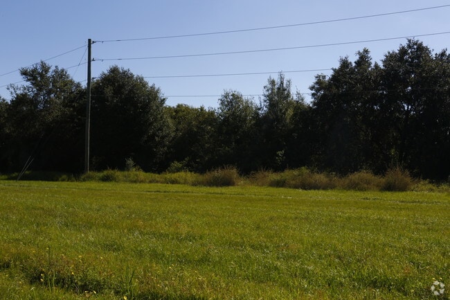
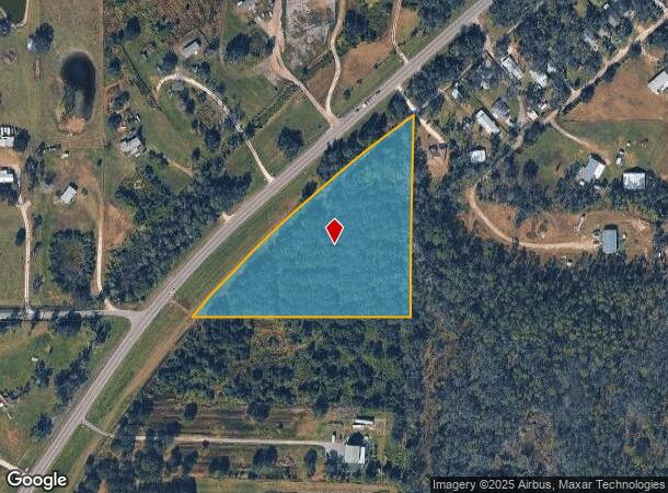
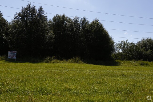
Property Record
14935 Us 301 N, Parrish, FL 34219
NEARBY LISTINGS FOR SALE OR LEASE
-
-
No Photo
-
View all Parrish listings for sale on LoopNet.com
Property Detail
14935 Us 301 N
3906-0150-9
A PARCEL OF LAND LYING IN SEC 3, TWN 33S, R 19E, MANATEECO.FL, AS DESCRIBED AS FOLLOWS: COM AT THE SW COR OF SEC3,TWN 33S, R 19E, MANATEE CO, FL; TH N 88 DEG 47 MIN 25
Vacantlandnec
Manatee
X
Florida
12057C0670J
5.14 AC
2023
Manatee Outlying
2025
Tampa/St Petersburg
001913
North Port-Bradenton-Sarasota, FL
DEMOGRAPHICS near 14935 Us 301 N
1 Mile
3 Mile
5 Mile
2024 Total Population
575
4,382
36,635
2029 Population
648
4,960
41,577
Pop Growth 2024-2029
+ 12.70%
+ 13.19%
+ 13.49%
Average Age
44
42
50
2024 Total Households
203
1,469
15,532
HH Growth 2024-2029
+ 12.32%
+ 12.46%
+ 13.24%
Median Household Inc
$92,856
$82,012
$60,533
Avg Household Size
2.60
2.80
2.20
2024 Avg HH Vehicles
2.00
2.00
2.00
Median Home Value
$358,749
$315,789
$221,067
Median Year Built
2000
2001
2001
Nearby Places
Map Layers
Map Styles
 Street
 Aerial
- Restaurants
- Banks
- Shops
- Fitness
- Groceries
PUBLIC TRANSPORTATION
AIRPORT
Sarasota/Bradenton International
DRIVE
WALK
Distance
Sarasota/Bradenton International
43 min
26.8 mi
Tampa International
DRIVE
WALK
Distance
Tampa International
55 min
37.8 mi
St Pete-Clearwater International
DRIVE
WALK
Distance
St Pete-Clearwater International
61 min
43.3 mi
Freight Ports
Port Manatee
DRIVE
WALK
Distance
Port Manatee
23 min
14.4 mi
SALE & LEASE HISTORY
LISTING DATE
SALE/LEASE

Mar 07, 2019
For Sale
Nearby Properties
Address
Land Use
TOTAL SIZE
Lot Size
Zoning
Address
Land Use
TOTAL SIZE
Lot Size
Zoning
483.51 AC
A,PD-R
Address
Land Use
TOTAL SIZE
Lot Size
Zoning
4,979 SF
1,480.87 AC
PD
Address
Land Use
TOTAL SIZE
Lot Size
Zoning
204.10 AC
PD
Address
Land Use
TOTAL SIZE
Lot Size
Zoning
139.83 AC
PD
Address
Land Use
TOTAL SIZE
Lot Size
Zoning
1,861 SF
61.85 AC
PD
Address
Land Use
TOTAL SIZE
Lot Size
Zoning
38,547 SF
26.88 AC
AS-1
Address
Land Use
TOTAL SIZE
Lot Size
Zoning
291.65 AC
AR
Address
Land Use
TOTAL SIZE
Lot Size
Zoning
22,733 SF
156.25 AC
PD
Address
Land Use
TOTAL SIZE
Lot Size
Zoning
Address
Land Use
TOTAL SIZE
Lot Size
Zoning
154.48 AC
AR
Address
Land Use
TOTAL SIZE
Lot Size
Zoning
145.29 AC
PD
Address
Land Use
TOTAL SIZE
Lot Size
Zoning
Address
Land Use
TOTAL SIZE
Lot Size
Zoning
30,720 SF
13.43 AC
AS-1
Address
Land Use
TOTAL SIZE
Lot Size
Zoning
71,726 SF
11.06 AC
AS-1
Address
Land Use
TOTAL SIZE
Lot Size
Zoning
58.47 AC
Address
Land Use
TOTAL SIZE
Lot Size
Zoning
66.49 AC
AR
Address
Land Use
TOTAL SIZE
Lot Size
Zoning
7,684 SF
17.06 AC
PD
Address
Land Use
TOTAL SIZE
Lot Size
Zoning
52,125 SF
358.64 AC
A GENERAL
Address
Land Use
TOTAL SIZE
Lot Size
Zoning
5,325 SF
4.86 AC
CG
Address
Land Use
TOTAL SIZE
Lot Size
Zoning
5,289 SF
1.26 AC
PD
Address
Land Use
TOTAL SIZE
Lot Size
Zoning
66.47 AC
AR
Address
Land Use
TOTAL SIZE
Lot Size
Zoning
2.11 AC
PD-MU
Address
Land Use
TOTAL SIZE
Lot Size
Zoning
1,924 SF
59.33 AC
AR
Address
Land Use
TOTAL SIZE
Lot Size
Zoning
3,504 SF
6.33 AC
A GENERAL
Address
Land Use
TOTAL SIZE
Lot Size
Zoning
34.21 AC
PD
Address
Land Use
TOTAL SIZE
Lot Size
Zoning
83.80 AC
AR
Address
Land Use
TOTAL SIZE
Lot Size
Zoning
14.98 AC
AS-1
Address
Land Use
TOTAL SIZE
Lot Size
Zoning
7,557 SF
4.70 AC
RDC-6
Address
Land Use
TOTAL SIZE
Lot Size
Zoning
1,806 SF
40.85 AC
AS-1
Address
Land Use
TOTAL SIZE
Lot Size
Zoning
69.54 AC
AR
The World's #1 Commercial Real Estate Marketplace
Connect with us
© 2026 CoStar Group
The information above has been obtained from sources believed reliable. While we do not doubt its accuracy we have not verified it and make no guarantee, warranty or representation about it. It is your responsibility to independently confirm its accuracy and completeness. Any projections, opinions, assumptions, or estimates used are for example only and do not represent the current or future performance of the property. The value of this transaction to you depends on tax and other factors which should be evaluated by your tax, financial, and legal advisors. You and your advisors should conduct a careful, independent investigation of the property to determine to your satisfaction the suitability of the property for your needs.