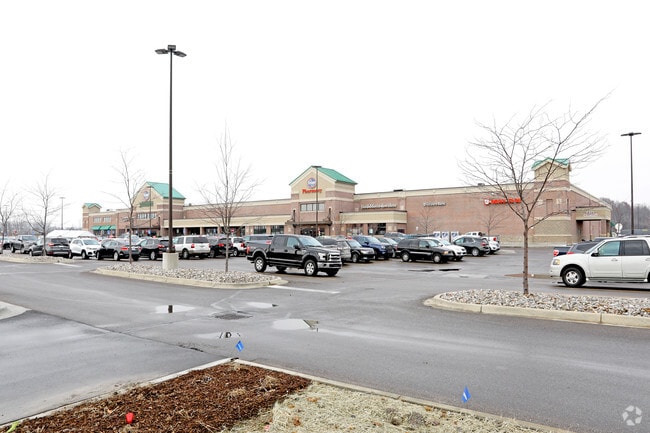
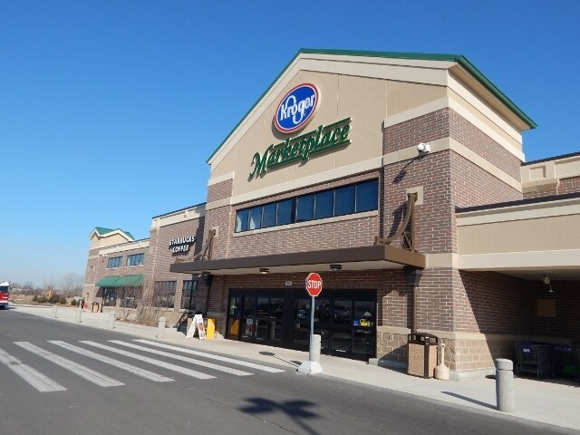
Property Record
14945 23 Mile Rd, Shelby Township, MI 48315

NEARBY LISTINGS FOR SALE OR LEASE
Property Detail
14945 23 Mile Rd
23-07-13-400-070
T3N, R12E, SEC 13; COMM AT SE COR SEC 13; TH S83*59'40" W 60.12 FT; TH N02*26'21"W 515.96 FT; TO POB TH S87*33'39"W 198.65
Supermarket
Macomb
X
Michigan
26099C0236G
13.97 AC
2025
Macomb West
2025
Detroit
226400
Detroit-Warren-Dearborn, MI
120,658 SF
DEMOGRAPHICS near 14945 23 Mile Rd
1 Mile
3 Mile
5 Mile
2024 Total Population
6,148
76,674
192,890
2029 Population
6,127
75,510
190,446
Pop Growth 2024-2029
(0.34%)
(1.52%)
(1.27%)
Average Age
42
42
41
2024 Total Households
2,204
27,124
73,982
HH Growth 2024-2029
(0.54%)
(1.72%)
(1.33%)
Median Household Inc
$106,441
$104,086
$87,025
Avg Household Size
2.80
2.80
2.60
2024 Avg HH Vehicles
2.00
2.00
2.00
Median Home Value
$359,286
$323,703
$296,297
Median Year Built
1995
1994
1992
Nearby Places
Map Layers
Map Styles
 Street
 Aerial
- Restaurants
- Banks
- Shops
- Fitness
- Groceries
PUBLIC TRANSPORTATION
AIRPORT
Windsor International
DRIVE
WALK
Distance
Windsor International
68 min
41.2 mi
SALE & LEASE HISTORY
LISTING DATE
SALE/LEASE

Aug 09, 2017
For Lease
Nearby Properties
Address
Land Use
TOTAL SIZE
Lot Size
Zoning
Address
Land Use
TOTAL SIZE
Lot Size
Zoning
447,434 SF
23.29 AC
LM
Address
Land Use
TOTAL SIZE
Lot Size
Zoning
371,520 SF
21.91 AC
CK MAP
Address
Land Use
TOTAL SIZE
Lot Size
Zoning
89,559 SF
44.54 AC
O2
Address
Land Use
TOTAL SIZE
Lot Size
Zoning
118,343 SF
7.33 AC
R1
Address
Land Use
TOTAL SIZE
Lot Size
Zoning
10.29 AC
LM
Address
Land Use
TOTAL SIZE
Lot Size
Zoning
90,185 SF
14.73 AC
C2
Address
Land Use
TOTAL SIZE
Lot Size
Zoning
224,323 SF
22.15 AC
C-3
Address
Land Use
TOTAL SIZE
Lot Size
Zoning
17.40 AC
CK MAP
Address
Land Use
TOTAL SIZE
Lot Size
Zoning
73.49 AC
CK MAP
Address
Land Use
TOTAL SIZE
Lot Size
Zoning
79,942 SF
4.65 AC
M1
Address
Land Use
TOTAL SIZE
Lot Size
Zoning
8.81 AC
C-6
Address
Land Use
TOTAL SIZE
Lot Size
Zoning
118,581 SF
15.17 AC
R-5
Address
Land Use
TOTAL SIZE
Lot Size
Zoning
121,156 SF
9.40 AC
CK MAP
Address
Land Use
TOTAL SIZE
Lot Size
Zoning
293,800 SF
M1
Address
Land Use
TOTAL SIZE
Lot Size
Zoning
134,400 SF
7.55 AC
CK MAP
Address
Land Use
TOTAL SIZE
Lot Size
Zoning
14.46 AC
R-7
Address
Land Use
TOTAL SIZE
Lot Size
Zoning
122,540 SF
CK MAP
Address
Land Use
TOTAL SIZE
Lot Size
Zoning
214,282 SF
22.26 AC
M1
Address
Land Use
TOTAL SIZE
Lot Size
Zoning
150,854 SF
8.50 AC
LM
Address
Land Use
TOTAL SIZE
Lot Size
Zoning
148,438 SF
4.82 AC
LM
Address
Land Use
TOTAL SIZE
Lot Size
Zoning
99,619 SF
8.24 AC
M1
Address
Land Use
TOTAL SIZE
Lot Size
Zoning
8.90 AC
R-1-B
Address
Land Use
TOTAL SIZE
Lot Size
Zoning
74,354 SF
10.62 AC
C3
Address
Land Use
TOTAL SIZE
Lot Size
Zoning
82,700 SF
9.75 AC
R-6
Address
Land Use
TOTAL SIZE
Lot Size
Zoning
312,087 SF
25.65 AC
M1
Address
Land Use
TOTAL SIZE
Lot Size
Zoning
56,766 SF
5.06 AC
C2
Address
Land Use
TOTAL SIZE
Lot Size
Zoning
99,188 SF
7.99 AC
LM
Address
Land Use
TOTAL SIZE
Lot Size
Zoning
4,064 SF
99.99 AC
R3
Address
Land Use
TOTAL SIZE
Lot Size
Zoning
104,455 SF
15.28 AC
LM
The World's #1 Commercial Real Estate Marketplace
Connect with us
© 2026 CoStar Group
The information above has been obtained from sources believed reliable. While we do not doubt its accuracy we have not verified it and make no guarantee, warranty or representation about it. It is your responsibility to independently confirm its accuracy and completeness. Any projections, opinions, assumptions, or estimates used are for example only and do not represent the current or future performance of the property. The value of this transaction to you depends on tax and other factors which should be evaluated by your tax, financial, and legal advisors. You and your advisors should conduct a careful, independent investigation of the property to determine to your satisfaction the suitability of the property for your needs.