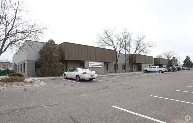
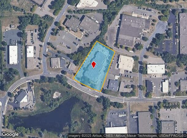
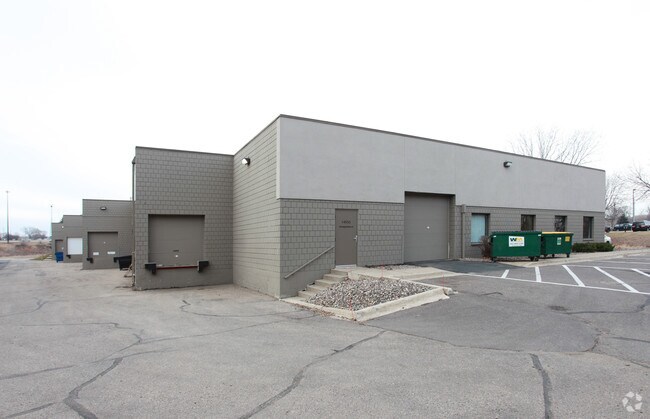
Property Record
14950 Martin Dr, Eden Prairie, MN 55344
Current Lease Availabilities
NEARBY LISTINGS FOR SALE OR LEASE
Property Detail
14950 Martin Dr
Minneapolis-St. Paul-Bloomington, MN-WI
Edenvale Industrial Park 3Rd Addn
09-116-22-43-0012
LOT 002 BLOCK 001 A EDENVALE INDUSTRIAL PARK 3RD ADDN S275X399X192X384
Industrialgeneral
Hennepin
X
Minnesota
27053C0430F
2
2024
2.12 AC
2024
Southwest
026006
Minneapolis/St Paul
28,080 SF
DEMOGRAPHICS near 14950 Martin Dr
1 Mile
3 Mile
5 Mile
2024 Total Population
7,465
57,131
134,912
2029 Population
7,368
56,189
134,331
Pop Growth 2024-2029
(1.30%)
(1.65%)
(0.43%)
Average Age
39
40
42
2024 Total Households
3,032
22,596
54,761
HH Growth 2024-2029
(1.62%)
(1.80%)
(0.50%)
Median Household Inc
$99,915
$113,083
$110,673
Avg Household Size
2.40
2.50
2.40
2024 Avg HH Vehicles
2.00
2.00
2.00
Median Home Value
$364,343
$420,178
$430,312
Median Year Built
1983
1987
1983
Nearby Places
- Restaurants
- Banks
- Shops
- Fitness
- Groceries
PUBLIC TRANSPORTATION
AIRPORT
Minneapolis-St Paul International/Wold-Chamberlain
DRIVE
WALK
Distance
Minneapolis-St Paul International/Wold-Chamberlain
21 min
14.0 mi
Nearby Properties
Address
Land Use
TOTAL SIZE
Lot Size
Zoning
Address
Land Use
TOTAL SIZE
Lot Size
Zoning
49,799 SF
4.96 AC
Address
Land Use
TOTAL SIZE
Lot Size
Zoning
Address
Land Use
TOTAL SIZE
Lot Size
Zoning
49,757 SF
2.88 AC
Address
Land Use
TOTAL SIZE
Lot Size
Zoning
136,782 SF
6.17 AC
Address
Land Use
TOTAL SIZE
Lot Size
Zoning
216,984 SF
14.48 AC
RM25
Address
Land Use
TOTAL SIZE
Lot Size
Zoning
226,252 SF
5.40 AC
Address
Land Use
TOTAL SIZE
Lot Size
Zoning
175,506 SF
14.32 AC
Address
Land Use
TOTAL SIZE
Lot Size
Zoning
10.01 AC
RM25
Address
Land Use
TOTAL SIZE
Lot Size
Zoning
314,234 SF
2.31 AC
RM25
Address
Land Use
TOTAL SIZE
Lot Size
Zoning
327,536 SF
4.76 AC
CCOM
Address
Land Use
TOTAL SIZE
Lot Size
Zoning
166,989 SF
9.70 AC
RM25
Address
Land Use
TOTAL SIZE
Lot Size
Zoning
181,201 SF
8.30 AC
OFC
Address
Land Use
TOTAL SIZE
Lot Size
Zoning
9.94 AC
RM25
Address
Land Use
TOTAL SIZE
Lot Size
Zoning
12.57 AC
RM25
Address
Land Use
TOTAL SIZE
Lot Size
Zoning
7.30 AC
RM25
Address
Land Use
TOTAL SIZE
Lot Size
Zoning
5.77 AC
RM25
Address
Land Use
TOTAL SIZE
Lot Size
Zoning
325,341 SF
35.31 AC
C-REG
Address
Land Use
TOTAL SIZE
Lot Size
Zoning
298,582 SF
31.71 AC
OFC
Address
Land Use
TOTAL SIZE
Lot Size
Zoning
107,652 SF
9.82 AC
OFC
Address
Land Use
TOTAL SIZE
Lot Size
Zoning
130,990 SF
18.27 AC
C-REG
Address
Land Use
TOTAL SIZE
Lot Size
Zoning
8.38 AC
PUD
Address
Land Use
TOTAL SIZE
Lot Size
Zoning
46,726 SF
2.65 AC
PUD
Address
Land Use
TOTAL SIZE
Lot Size
Zoning
536,598 SF
53.84 AC
I-5
Address
Land Use
TOTAL SIZE
Lot Size
Zoning
70,129 SF
13.03 AC
RM25
Address
Land Use
TOTAL SIZE
Lot Size
Zoning
129,037 SF
16.73 AC
RM25
Address
Land Use
TOTAL SIZE
Lot Size
Zoning
191,179 SF
22.62 AC
Address
Land Use
TOTAL SIZE
Lot Size
Zoning
206,200 SF
8.97 AC
RM25
Address
Land Use
TOTAL SIZE
Lot Size
Zoning
8.19 AC
RM25
Address
Land Use
TOTAL SIZE
Lot Size
Zoning
56,718 SF
2.43 AC
Address
Land Use
TOTAL SIZE
Lot Size
Zoning
118,338 SF
8.55 AC
RM25
The World's #1 Commercial Real Estate Marketplace
Connect with us
© 2025 CoStar Group
The information above has been obtained from sources believed reliable. While we do not doubt its accuracy we have not verified it and make no guarantee, warranty or representation about it. It is your responsibility to independently confirm its accuracy and completeness. Any projections, opinions, assumptions, or estimates used are for example only and do not represent the current or future performance of the property. The value of this transaction to you depends on tax and other factors which should be evaluated by your tax, financial, and legal advisors. You and your advisors should conduct a careful, independent investigation of the property to determine to your satisfaction the suitability of the property for your needs.