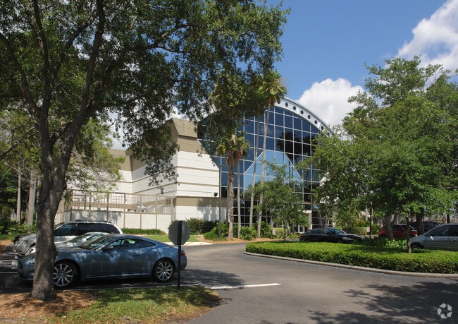
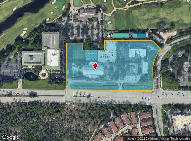
Property Record
1499 W Yamato Rd, Boca Raton, FL 33431
NEARBY LISTINGS FOR SALE OR LEASE
-
-
-
-
-
No Photo
-
-
-
View all Boca Raton listings for sale on LoopNet.com
Property Detail
1499 W Yamato Rd
06-42-47-01-17-000-0060
Sportland Cond Land
Theater
SPORTLAND COND LAND UNIT 6
AH
Palm Beach
12099C0988G
Florida
2024
6.64 AC
2025
Boca Raton North
007012
South Florida
153,308 SF
West Palm Beach-Boca Raton-Delray Beach, FL
DEMOGRAPHICS near 1499 W Yamato Rd
1 Mile
3 Mile
5 Mile
2024 Total Population
5,719
81,358
261,656
2029 Population
6,094
84,593
275,433
Pop Growth 2024-2029
+ 6.56%
+ 3.98%
+ 5.27%
Average Age
40
44
49
2024 Total Households
2,844
33,191
122,163
HH Growth 2024-2029
+ 6.43%
+ 3.95%
+ 5.36%
Median Household Inc
$91,873
$90,206
$71,894
Avg Household Size
2.00
2.10
2.00
2024 Avg HH Vehicles
1.00
2.00
2.00
Median Home Value
$643,433
$487,703
$414,028
Median Year Built
2010
1985
1984
Nearby Places
Map Layers
Map Styles
 Street
 Aerial
- Restaurants
- Banks
- Shops
- Fitness
- Groceries
PUBLIC TRANSPORTATION
COMMUTER RAIL
Boca Raton (Tri-County Commuter - South Florida Regional Transportation Authority (Tri-Rail))
DRIVE
WALK
Distance
Boca Raton (Tri-County Commuter - South Florida Regional Transportation Authority (Tri-Rail))
4 min
1.4 mi
Boca Raton (Mainline - Brightline)
DRIVE
WALK
Distance
Boca Raton (Mainline - Brightline)
11 min
5.2 mi
AIRPORT
Palm Beach International
DRIVE
WALK
Distance
Palm Beach International
33 min
24.5 mi
Fort Lauderdale/Hollywood International
DRIVE
WALK
Distance
Fort Lauderdale/Hollywood International
37 min
27.5 mi
Freight Ports
Port Everglades
DRIVE
WALK
Distance
Port Everglades
36 min
26.1 mi
Nearby Properties
Address
Land Use
TOTAL SIZE
Lot Size
Zoning
Address
Land Use
TOTAL SIZE
Lot Size
Zoning
824,107 SF
39.08 AC
CITY CG
Address
Land Use
TOTAL SIZE
Lot Size
Zoning
2,250,267 SF
260 AC
PL
Address
Land Use
TOTAL SIZE
Lot Size
Zoning
2,361,481 SF
120.60 AC
PL
Address
Land Use
TOTAL SIZE
Lot Size
Zoning
779,243 SF
205.02 AC
PL
Address
Land Use
TOTAL SIZE
Lot Size
Zoning
491,320 SF
11.51 AC
LIRP PMD
Address
Land Use
TOTAL SIZE
Lot Size
Zoning
437,556 SF
11.50 AC
LIRP PMD
Address
Land Use
TOTAL SIZE
Lot Size
Zoning
467,728 SF
18.73 AC
LIRP PMD
Address
Land Use
TOTAL SIZE
Lot Size
Zoning
791,490 SF
114.95 AC
R-1-A
Address
Land Use
TOTAL SIZE
Lot Size
Zoning
1,949,101 SF
123.29 AC
LIRP
Address
Land Use
TOTAL SIZE
Lot Size
Zoning
373,856 SF
4.12 AC
LIRP PMD
Address
Land Use
TOTAL SIZE
Lot Size
Zoning
532,985 SF
34.40 AC
RM-10
Address
Land Use
TOTAL SIZE
Lot Size
Zoning
360,718 SF
3.67 AC
LIRP PMD
Address
Land Use
TOTAL SIZE
Lot Size
Zoning
420,742 SF
29.63 AC
R-3-F
Address
Land Use
TOTAL SIZE
Lot Size
Zoning
760,812 SF
23.60 AC
MC
Address
Land Use
TOTAL SIZE
Lot Size
Zoning
542,392 SF
27.95 AC
R-1-D
Address
Land Use
TOTAL SIZE
Lot Size
Zoning
617,920 SF
7.75 AC
R-B-1
Address
Land Use
TOTAL SIZE
Lot Size
Zoning
1,090,620 SF
28.89 AC
LIRP
Address
Land Use
TOTAL SIZE
Lot Size
Zoning
293,358 SF
9.05 AC
LIRP PMD
Address
Land Use
TOTAL SIZE
Lot Size
Zoning
251,039 SF
11 AC
SAD
Address
Land Use
TOTAL SIZE
Lot Size
Zoning
377,672 SF
35.64 AC
PL
Address
Land Use
TOTAL SIZE
Lot Size
Zoning
228,097 SF
10.63 AC
M-2
Address
Land Use
TOTAL SIZE
Lot Size
Zoning
388,602 SF
74.99 AC
R-1-A
Address
Land Use
TOTAL SIZE
Lot Size
Zoning
242,023 SF
15.38 AC
RS
Address
Land Use
TOTAL SIZE
Lot Size
Zoning
259,054 SF
14.95 AC
POI
Address
Land Use
TOTAL SIZE
Lot Size
Zoning
352,250 SF
9.93 AC
CITY CHO
Address
Land Use
TOTAL SIZE
Lot Size
Zoning
380,823 SF
23.10 AC
LIRP PMD
Address
Land Use
TOTAL SIZE
Lot Size
Zoning
299,038 SF
11.78 AC
POI*
Address
Land Use
TOTAL SIZE
Lot Size
Zoning
240,047 SF
12.13 AC
RS
Address
Land Use
TOTAL SIZE
Lot Size
Zoning
194,972 SF
48.62 AC
PL
Address
Land Use
TOTAL SIZE
Lot Size
Zoning
214,166 SF
9.10 AC
LIRP PMD
The World's #1 Commercial Real Estate Marketplace
Connect with us
© 2025 CoStar Group
The information above has been obtained from sources believed reliable. While we do not doubt its accuracy we have not verified it and make no guarantee, warranty or representation about it. It is your responsibility to independently confirm its accuracy and completeness. Any projections, opinions, assumptions, or estimates used are for example only and do not represent the current or future performance of the property. The value of this transaction to you depends on tax and other factors which should be evaluated by your tax, financial, and legal advisors. You and your advisors should conduct a careful, independent investigation of the property to determine to your satisfaction the suitability of the property for your needs.