Property Record
14N668 Getzelman Rd, Hampshire, IL 60140
NEARBY LISTINGS FOR SALE OR LEASE
Property Detail
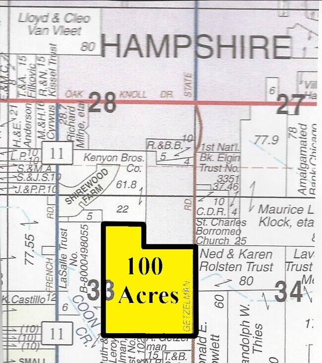
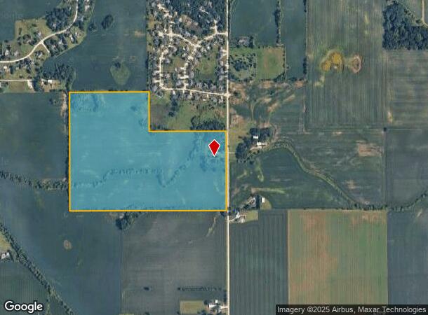
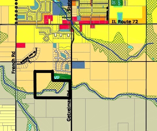
14N668 Getzelman Rd
Taxexempt
Kane
AE
Illinois
17089C0109J
100 AC
2023
Western East/West Corr
2024
Chicago
850705
Chicago-Naperville-Elgin, IL-IN-WI
2,098 SF
01-33-200-003
DEMOGRAPHICS near 14N668 Getzelman Rd
1 Mile
3 Mile
5 Mile
2024 Total Population
934
7,711
14,279
2029 Population
922
7,639
14,108
Pop Growth 2024-2029
(1.28%)
(0.93%)
(1.20%)
Average Age
38
40
38
2024 Total Households
325
2,806
5,000
HH Growth 2024-2029
(1.23%)
(1.10%)
(1.34%)
Median Household Inc
$109,264
$99,362
$108,140
Avg Household Size
2.80
2.70
2.80
2024 Avg HH Vehicles
3.00
2.00
2.00
Median Home Value
$340,277
$321,279
$317,374
Median Year Built
2001
1991
2001
Nearby Places
Map Layers
Map Styles
 Street
 Aerial
- Restaurants
- Banks
- Shops
- Fitness
- Groceries
SALE & LEASE HISTORY
LISTING DATE
SALE/LEASE

Apr 08, 2021
For Sale
Nearby Properties
Address
Land Use
TOTAL SIZE
Lot Size
Zoning
Address
Land Use
TOTAL SIZE
Lot Size
Zoning
152,275 SF
12.22 AC
I DISTRICT
Address
Land Use
TOTAL SIZE
Lot Size
Zoning
44,800 SF
35.39 AC
M2 MANUFAC
Address
Land Use
TOTAL SIZE
Lot Size
Zoning
1.75 AC
Address
Land Use
TOTAL SIZE
Lot Size
Zoning
Address
Land Use
TOTAL SIZE
Lot Size
Zoning
55,292 SF
3.58 AC
Address
Land Use
TOTAL SIZE
Lot Size
Zoning
162,846 SF
4.71 AC
Address
Land Use
TOTAL SIZE
Lot Size
Zoning
28,900 SF
9 AC
I DISTRICT
Address
Land Use
TOTAL SIZE
Lot Size
Zoning
23,626 SF
1.98 AC
I DISTRICT
Address
Land Use
TOTAL SIZE
Lot Size
Zoning
4.83 AC
Address
Land Use
TOTAL SIZE
Lot Size
Zoning
46,596 SF
5.66 AC
M1 MANUFAC
Address
Land Use
TOTAL SIZE
Lot Size
Zoning
29,863 SF
3.27 AC
I DISTRICT
Address
Land Use
TOTAL SIZE
Lot Size
Zoning
3.81 AC
Address
Land Use
TOTAL SIZE
Lot Size
Zoning
30,607 SF
2.36 AC
B1 DISTRIC
Address
Land Use
TOTAL SIZE
Lot Size
Zoning
23,754 SF
1.87 AC
I DISTRICT
Address
Land Use
TOTAL SIZE
Lot Size
Zoning
1.16 AC
Address
Land Use
TOTAL SIZE
Lot Size
Zoning
18,317 SF
2.06 AC
B2 DISTRIC
Address
Land Use
TOTAL SIZE
Lot Size
Zoning
18,080 SF
1.93 AC
M1 MANUFAC
Address
Land Use
TOTAL SIZE
Lot Size
Zoning
34,215 SF
2.64 AC
B2 DISTRIC
Address
Land Use
TOTAL SIZE
Lot Size
Zoning
1.79 AC
Address
Land Use
TOTAL SIZE
Lot Size
Zoning
43,300 SF
1.81 AC
B2 DISTRIC
Address
Land Use
TOTAL SIZE
Lot Size
Zoning
72,000 SF
2.07 AC
B2 DISTRIC
Address
Land Use
TOTAL SIZE
Lot Size
Zoning
3,151 SF
2.52 AC
B3 DISTRIC
Address
Land Use
TOTAL SIZE
Lot Size
Zoning
3,339 SF
0.95 AC
B2 DISTRIC
Address
Land Use
TOTAL SIZE
Lot Size
Zoning
Address
Land Use
TOTAL SIZE
Lot Size
Zoning
6,658 SF
1.48 AC
B2 DISTRIC
Address
Land Use
TOTAL SIZE
Lot Size
Zoning
5,670 SF
2.36 AC
B2 DISTRIC
Address
Land Use
TOTAL SIZE
Lot Size
Zoning
9,399 SF
0.78 AC
Address
Land Use
TOTAL SIZE
Lot Size
Zoning
4,000 SF
6.20 AC
I DISTRICT
The World's #1 Commercial Real Estate Marketplace
Connect with us
© 2025 CoStar Group
The information above has been obtained from sources believed reliable. While we do not doubt its accuracy we have not verified it and make no guarantee, warranty or representation about it. It is your responsibility to independently confirm its accuracy and completeness. Any projections, opinions, assumptions, or estimates used are for example only and do not represent the current or future performance of the property. The value of this transaction to you depends on tax and other factors which should be evaluated by your tax, financial, and legal advisors. You and your advisors should conduct a careful, independent investigation of the property to determine to your satisfaction the suitability of the property for your needs.