Property Record
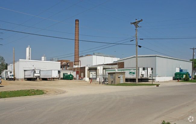
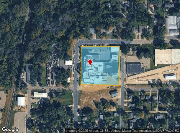
15 4Th St, Farmington, MN 55024

NEARBY LISTINGS FOR SALE OR LEASE
Property Detail
15 4Th St
Minneapolis-St. Paul-Bloomington, MN-WI
Town Of Farmington
14-77000-32-010
32 ALL OF BLK 32 EX RR ALSO VAC ALLEY WITHIN BLK 32 & VAC W 5 FT OF 5TH ST BETWEEN N LINE OF PINE ST & S LINE OF WILLOW ST & VAC N 2 FT OF PINE ST BETWEEN E LINE OF 4TH ST & W LINE OF 5TH ST TOWN OF FARMINGTON
Industrialgeneral
Dakota
X
Minnesota
27037C0219E
10
2024
3.04 AC
2024
South Central
060904
Minneapolis/St Paul
100,258 SF
DEMOGRAPHICS near 15 4Th St
1 Mile
3 Mile
5 Mile
2024 Total Population
7,259
22,926
48,551
2029 Population
7,438
23,441
50,027
Pop Growth 2024-2029
+ 2.47%
+ 2.25%
+ 3.04%
Average Age
36
36
36
2024 Total Households
2,523
7,628
16,182
HH Growth 2024-2029
+ 2.38%
+ 2.16%
+ 3.09%
Median Household Inc
$80,549
$109,621
$110,689
Avg Household Size
2.70
2.90
2.90
2024 Avg HH Vehicles
2.00
2.00
2.00
Median Home Value
$264,669
$331,897
$348,301
Median Year Built
1988
1999
2000
Nearby Places
Map Layers
Map Styles
 Street
 Aerial
- Restaurants
- Banks
- Shops
- Fitness
- Groceries
PUBLIC TRANSPORTATION
AIRPORT
Minneapolis-St Paul International/Wold-Chamberlain
DRIVE
WALK
Distance
Minneapolis-St Paul International/Wold-Chamberlain
33 min
21.7 mi
Freight Ports
Port Milwaukee
DRIVE
WALK
Distance
Port Milwaukee
376 min
338.0 mi
Nearby Properties
Address
Land Use
TOTAL SIZE
Lot Size
Zoning
Address
Land Use
TOTAL SIZE
Lot Size
Zoning
78.77 AC
Address
Land Use
TOTAL SIZE
Lot Size
Zoning
147,983 SF
46.75 AC
Address
Land Use
TOTAL SIZE
Lot Size
Zoning
147,426 SF
29.47 AC
Address
Land Use
TOTAL SIZE
Lot Size
Zoning
160,611 SF
14.08 AC
Address
Land Use
TOTAL SIZE
Lot Size
Zoning
141,819 SF
12.95 AC
Address
Land Use
TOTAL SIZE
Lot Size
Zoning
79,076 SF
3.14 AC
Address
Land Use
TOTAL SIZE
Lot Size
Zoning
92,744 SF
31.10 AC
Address
Land Use
TOTAL SIZE
Lot Size
Zoning
94,244 SF
4.06 AC
Address
Land Use
TOTAL SIZE
Lot Size
Zoning
176,291 SF
13.79 AC
Address
Land Use
TOTAL SIZE
Lot Size
Zoning
48,990 SF
1.19 AC
Address
Land Use
TOTAL SIZE
Lot Size
Zoning
105,040 SF
19.97 AC
Address
Land Use
TOTAL SIZE
Lot Size
Zoning
77,816 SF
18.01 AC
Address
Land Use
TOTAL SIZE
Lot Size
Zoning
115,984 SF
0.47 AC
Address
Land Use
TOTAL SIZE
Lot Size
Zoning
69,984 SF
4.66 AC
Address
Land Use
TOTAL SIZE
Lot Size
Zoning
11.63 AC
Address
Land Use
TOTAL SIZE
Lot Size
Zoning
37,738 SF
4.68 AC
Address
Land Use
TOTAL SIZE
Lot Size
Zoning
46,380 SF
4.78 AC
Address
Land Use
TOTAL SIZE
Lot Size
Zoning
49,001 SF
4.41 AC
Address
Land Use
TOTAL SIZE
Lot Size
Zoning
26,840 SF
9.16 AC
Address
Land Use
TOTAL SIZE
Lot Size
Zoning
78,483 SF
9.72 AC
Address
Land Use
TOTAL SIZE
Lot Size
Zoning
48,056 SF
4.22 AC
Address
Land Use
TOTAL SIZE
Lot Size
Zoning
25,621 SF
2.63 AC
Address
Land Use
TOTAL SIZE
Lot Size
Zoning
94,882 SF
5 AC
Address
Land Use
TOTAL SIZE
Lot Size
Zoning
33,480 SF
3.38 AC
Address
Land Use
TOTAL SIZE
Lot Size
Zoning
5.71 AC
Address
Land Use
TOTAL SIZE
Lot Size
Zoning
30,758 SF
1.31 AC
Address
Land Use
TOTAL SIZE
Lot Size
Zoning
15,207 SF
1.58 AC
Address
Land Use
TOTAL SIZE
Lot Size
Zoning
27,200 SF
7.76 AC
Address
Land Use
TOTAL SIZE
Lot Size
Zoning
25,876 SF
1.68 AC
Address
Land Use
TOTAL SIZE
Lot Size
Zoning
14,341 SF
2.26 AC
The World's #1 Commercial Real Estate Marketplace
Connect with us
© 2026 CoStar Group
The information above has been obtained from sources believed reliable. While we do not doubt its accuracy we have not verified it and make no guarantee, warranty or representation about it. It is your responsibility to independently confirm its accuracy and completeness. Any projections, opinions, assumptions, or estimates used are for example only and do not represent the current or future performance of the property. The value of this transaction to you depends on tax and other factors which should be evaluated by your tax, financial, and legal advisors. You and your advisors should conduct a careful, independent investigation of the property to determine to your satisfaction the suitability of the property for your needs.