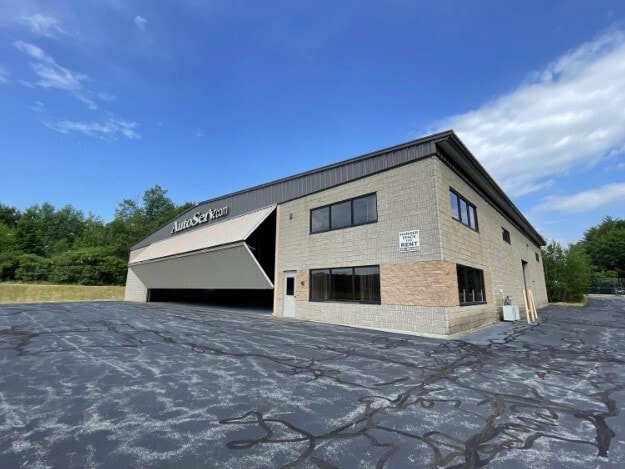
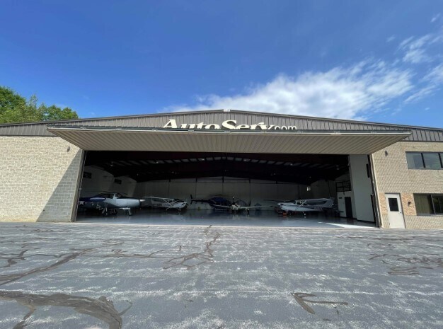
Property Record
15 Aviation Way, Gilford, NH 03249

NEARBY LISTINGS FOR SALE OR LEASE
-
-
View all Gilford listings for sale on LoopNet.com
Property Detail
15 Aviation Way
Laconia, NH
Belknap
GIFL-000214-000032
New Hampshire
Warehouse
1.19 AC
2024
Concord/New Hampshire North Area
2024
Other Market Areas
966403
DEMOGRAPHICS near 15 Aviation Way
1 Mile
3 Mile
5 Mile
2024 Total Population
945
13,407
29,127
2029 Population
1,022
14,427
30,882
Pop Growth 2024-2029
+ 8.15%
+ 7.61%
+ 6.03%
Average Age
49
49
46
2024 Total Households
443
6,192
12,966
HH Growth 2024-2029
+ 8.35%
+ 7.59%
+ 5.97%
Median Household Inc
$98,863
$90,812
$77,176
Avg Household Size
2.10
2.10
2.20
2024 Avg HH Vehicles
2.00
2.00
2.00
Median Home Value
$391,488
$351,878
$321,670
Median Year Built
1983
1983
1978
Nearby Places
Map Layers
Map Styles
 Street
 Aerial
- Restaurants
- Banks
- Shops
- Fitness
- Groceries
SALE & LEASE HISTORY
LISTING DATE
SALE/LEASE

Jul 22, 2022
For Sale
Nearby Properties
Address
Land Use
TOTAL SIZE
Lot Size
Zoning
Address
Land Use
TOTAL SIZE
Lot Size
Zoning
1,370 SF
92.23 AC
UC
Address
Land Use
TOTAL SIZE
Lot Size
Zoning
57.90 AC
C
Address
Land Use
TOTAL SIZE
Lot Size
Zoning
26 AC
SFR
Address
Land Use
TOTAL SIZE
Lot Size
Zoning
1,954 SF
Address
Land Use
TOTAL SIZE
Lot Size
Zoning
21.50 AC
C
Address
Land Use
TOTAL SIZE
Lot Size
Zoning
9.63 AC
C
Address
Land Use
TOTAL SIZE
Lot Size
Zoning
343.45 AC
I
Address
Land Use
TOTAL SIZE
Lot Size
Zoning
53,766 SF
1.30 AC
UC
Address
Land Use
TOTAL SIZE
Lot Size
Zoning
104,952 SF
5.10 AC
C
Address
Land Use
TOTAL SIZE
Lot Size
Zoning
276 SF
21.72 AC
RS
Address
Land Use
TOTAL SIZE
Lot Size
Zoning
30,930 SF
11.11 AC
UC
Address
Land Use
TOTAL SIZE
Lot Size
Zoning
31 AC
SFR
Address
Land Use
TOTAL SIZE
Lot Size
Zoning
0.62 AC
SFR
Address
Land Use
TOTAL SIZE
Lot Size
Zoning
15,086 SF
4.82 AC
CR
Address
Land Use
TOTAL SIZE
Lot Size
Zoning
8,318 SF
0.77 AC
SFR
Address
Land Use
TOTAL SIZE
Lot Size
Zoning
Address
Land Use
TOTAL SIZE
Lot Size
Zoning
10 AC
C
Address
Land Use
TOTAL SIZE
Lot Size
Zoning
1,600 SF
4.40 AC
CR
Address
Land Use
TOTAL SIZE
Lot Size
Zoning
528 SF
17 AC
UC
Address
Land Use
TOTAL SIZE
Lot Size
Zoning
1.60 AC
SFR
Address
Land Use
TOTAL SIZE
Lot Size
Zoning
35,647 SF
38 AC
RS
Address
Land Use
TOTAL SIZE
Lot Size
Zoning
2,860 SF
1.70 AC
SFR
Address
Land Use
TOTAL SIZE
Lot Size
Zoning
6.60 AC
SFR
Address
Land Use
TOTAL SIZE
Lot Size
Zoning
0.92 AC
RC
Address
Land Use
TOTAL SIZE
Lot Size
Zoning
968 SF
1.39 AC
SFR
Address
Land Use
TOTAL SIZE
Lot Size
Zoning
99.90 AC
NRR
Address
Land Use
TOTAL SIZE
Lot Size
Zoning
41,350 SF
2.51 AC
UC
Address
Land Use
TOTAL SIZE
Lot Size
Zoning
5,674 SF
1.60 AC
CR
Address
Land Use
TOTAL SIZE
Lot Size
Zoning
4,345 SF
1.10 AC
SFR
Address
Land Use
TOTAL SIZE
Lot Size
Zoning
6,070 SF
0.80 AC
SFR
The World's #1 Commercial Real Estate Marketplace
Connect with us
© 2025 CoStar Group
The information above has been obtained from sources believed reliable. While we do not doubt its accuracy we have not verified it and make no guarantee, warranty or representation about it. It is your responsibility to independently confirm its accuracy and completeness. Any projections, opinions, assumptions, or estimates used are for example only and do not represent the current or future performance of the property. The value of this transaction to you depends on tax and other factors which should be evaluated by your tax, financial, and legal advisors. You and your advisors should conduct a careful, independent investigation of the property to determine to your satisfaction the suitability of the property for your needs.