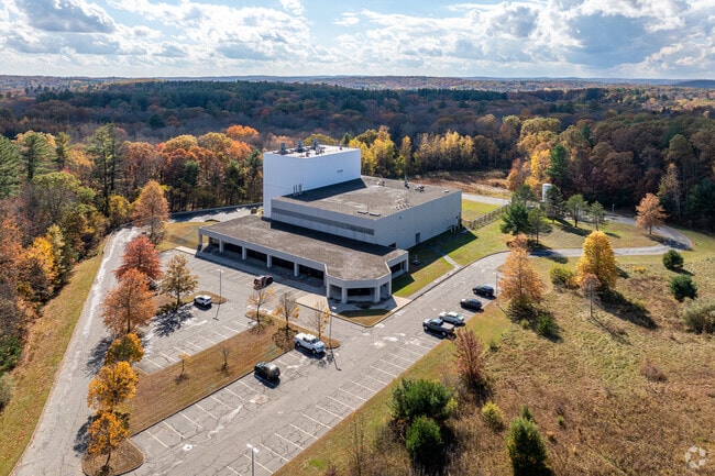
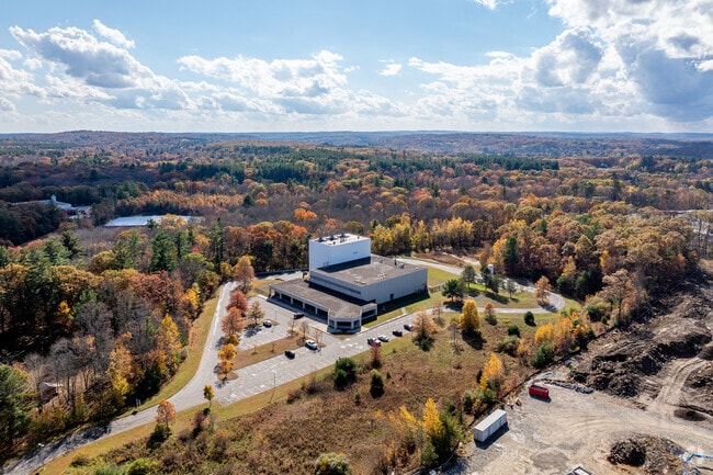
Property Record
15 Centennial Dr, North Grafton, MA 01536

NEARBY LISTINGS FOR SALE OR LEASE
Property Detail
15 Centennial Dr
GRAF-000005-000000-000001A
Worcester
Manufacturinglight
Massachusetts
X
1.a
25027C0827E
14.48 AC
2025
The Boroughs
2025
Boston
761300
Worcester, MA-CT
77,251 SF
DEMOGRAPHICS near 15 Centennial Dr
1 Mile
3 Mile
5 Mile
2024 Total Population
1,063
36,918
121,827
2029 Population
1,067
37,096
121,661
Pop Growth 2024-2029
+ 0.38%
+ 0.48%
(0.14%)
Average Age
39
40
41
2024 Total Households
359
13,886
47,487
HH Growth 2024-2029
+ 0.56%
+ 0.50%
(0.12%)
Median Household Inc
$144,564
$121,207
$101,805
Avg Household Size
2.80
2.60
2.50
2024 Avg HH Vehicles
2.00
2.00
2.00
Median Home Value
$531,716
$476,797
$441,145
Median Year Built
1992
1983
1975
Nearby Places
Map Layers
Map Styles
 Street
 Aerial
- Restaurants
- Banks
- Shops
- Fitness
- Groceries
PUBLIC TRANSPORTATION
COMMUTER RAIL
Grafton (Framingham/Worcester Line - Massachusetts Bay Transportation Authority Commuter Rail (Purple Line))
DRIVE
WALK
Distance
Grafton (Framingham/Worcester Line - Massachusetts Bay Transportation Authority Commuter Rail (Purple Line))
3 min
15 min
0.6 mi
Westborough (Framingham/Worcester Line - Massachusetts Bay Transportation Authority Commuter Rail (Purple Line))
DRIVE
WALK
Distance
Westborough (Framingham/Worcester Line - Massachusetts Bay Transportation Authority Commuter Rail (Purple Line))
10 min
3.8 mi
AIRPORT
Worcester Regional
DRIVE
WALK
Distance
Worcester Regional
27 min
13.6 mi
Freight Ports
Port of Boston
DRIVE
WALK
Distance
Port of Boston
59 min
39.2 mi
Nearby Properties
Address
Land Use
TOTAL SIZE
Lot Size
Zoning
Address
Land Use
TOTAL SIZE
Lot Size
Zoning
42.01 AC
I
Address
Land Use
TOTAL SIZE
Lot Size
Zoning
68.85 AC
OFF-RE
Address
Land Use
TOTAL SIZE
Lot Size
Zoning
46.50 AC
R4
Address
Land Use
TOTAL SIZE
Lot Size
Zoning
22.40 AC
COM BU
Address
Land Use
TOTAL SIZE
Lot Size
Zoning
67.29 AC
IB
Address
Land Use
TOTAL SIZE
Lot Size
Zoning
43.07 AC
COM BU
Address
Land Use
TOTAL SIZE
Lot Size
Zoning
23.65 AC
RUR A
Address
Land Use
TOTAL SIZE
Lot Size
Zoning
19.69 AC
BA
Address
Land Use
TOTAL SIZE
Lot Size
Zoning
375.66 AC
OLI
Address
Land Use
TOTAL SIZE
Lot Size
Zoning
107,308 SF
45.40 AC
M-1
Address
Land Use
TOTAL SIZE
Lot Size
Zoning
412,272 SF
42.44 AC
OFF-RE
Address
Land Use
TOTAL SIZE
Lot Size
Zoning
21.04 AC
APT 99
Address
Land Use
TOTAL SIZE
Lot Size
Zoning
203,184 SF
0.21 AC
MF-1
Address
Land Use
TOTAL SIZE
Lot Size
Zoning
10.28 AC
R
Address
Land Use
TOTAL SIZE
Lot Size
Zoning
9.70 AC
COM BU
Address
Land Use
TOTAL SIZE
Lot Size
Zoning
0.99 AC
MF-1 9
Address
Land Use
TOTAL SIZE
Lot Size
Zoning
134,896 SF
15.10 AC
LIM IN
Address
Land Use
TOTAL SIZE
Lot Size
Zoning
170,000 SF
27.66 AC
BA
Address
Land Use
TOTAL SIZE
Lot Size
Zoning
99,908 SF
18.28 AC
RUR AA
Address
Land Use
TOTAL SIZE
Lot Size
Zoning
102,181 SF
38.62 AC
RES B-
Address
Land Use
TOTAL SIZE
Lot Size
Zoning
93,092 SF
162.83 AC
OLI
Address
Land Use
TOTAL SIZE
Lot Size
Zoning
15.26 AC
COM BU
Address
Land Use
TOTAL SIZE
Lot Size
Zoning
12.96 AC
MF-1
Address
Land Use
TOTAL SIZE
Lot Size
Zoning
10.34 AC
APT 91
Address
Land Use
TOTAL SIZE
Lot Size
Zoning
19.05 AC
I
Address
Land Use
TOTAL SIZE
Lot Size
Zoning
40.46 AC
R4
Address
Land Use
TOTAL SIZE
Lot Size
Zoning
22.06 AC
COM BU
Address
Land Use
TOTAL SIZE
Lot Size
Zoning
184,960 SF
23.58 AC
IB
Address
Land Use
TOTAL SIZE
Lot Size
Zoning
82,843 SF
15.70 AC
R4
Address
Land Use
TOTAL SIZE
Lot Size
Zoning
11.10 AC
COM BU
The World's #1 Commercial Real Estate Marketplace
Connect with us
© 2025 CoStar Group
The information above has been obtained from sources believed reliable. While we do not doubt its accuracy we have not verified it and make no guarantee, warranty or representation about it. It is your responsibility to independently confirm its accuracy and completeness. Any projections, opinions, assumptions, or estimates used are for example only and do not represent the current or future performance of the property. The value of this transaction to you depends on tax and other factors which should be evaluated by your tax, financial, and legal advisors. You and your advisors should conduct a careful, independent investigation of the property to determine to your satisfaction the suitability of the property for your needs.