Property Record
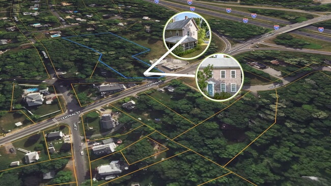
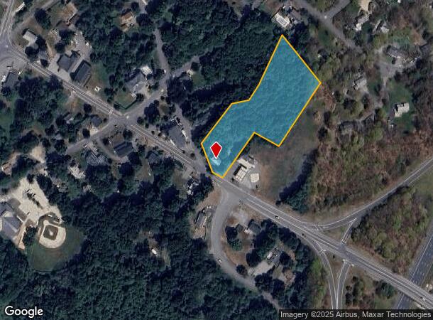
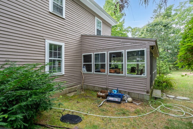
15 Central St, Byfield, MA 01922
This Property Is For Sale
NEARBY LISTINGS FOR SALE OR LEASE
Property Detail
15 Central St
Boston-Cambridge-Newton, MA-NH
Essex
NEWB-000011U-000000-000053
Massachusetts
Sfr
2.70 AC
X
Amesbury/Ipswich
25009C0114G
Boston
1,728 SF
DEMOGRAPHICS near 15 Central St
1 Mile
3 Mile
5 Mile
2024 Total Population
1,686
10,297
41,327
2029 Population
1,661
10,313
41,561
Pop Growth 2024-2029
(1.48%)
+ 0.16%
+ 0.57%
Average Age
45
44
44
2024 Total Households
638
3,711
15,420
HH Growth 2024-2029
(1.72%)
(0.03%)
+ 0.34%
Median Household Inc
$174,053
$157,684
$135,327
Avg Household Size
2.60
2.70
2.60
2024 Avg HH Vehicles
2.00
2.00
2.00
Median Home Value
$699,404
$676,535
$642,396
Median Year Built
1976
1983
1975
Nearby Places
- Restaurants
- Banks
- Shops
- Fitness
- Groceries
PUBLIC TRANSPORTATION
COMMUTER RAIL
Newburyport (Newburyport/Rockport Line - Massachusetts Bay Transportation Authority Commuter Rail (Purple Line))
DRIVE
WALK
Distance
Newburyport (Newburyport/Rockport Line - Massachusetts Bay Transportation Authority Commuter Rail (Purple Line))
11 min
5.5 mi
Rowley (Newburyport/Rockport Line - Massachusetts Bay Transportation Authority Commuter Rail (Purple Line))
DRIVE
WALK
Distance
Rowley (Newburyport/Rockport Line - Massachusetts Bay Transportation Authority Commuter Rail (Purple Line))
14 min
6.9 mi
AIRPORT
Portsmouth International at Pease
DRIVE
WALK
Distance
Portsmouth International at Pease
35 min
25.7 mi
General Edward Lawrence Logan International
DRIVE
WALK
Distance
General Edward Lawrence Logan International
45 min
30.9 mi
Manchester Boston Regional
DRIVE
WALK
Distance
Manchester Boston Regional
65 min
41.1 mi
Freight Ports
Port of Boston
DRIVE
WALK
Distance
Port of Boston
48 min
33.9 mi
Nearby Properties
Address
Land Use
TOTAL SIZE
Lot Size
Zoning
Address
Land Use
TOTAL SIZE
Lot Size
Zoning
Address
Land Use
TOTAL SIZE
Lot Size
Zoning
205,329 SF
98 AC
AR40
Address
Land Use
TOTAL SIZE
Lot Size
Zoning
374,714 SF
98 AC
AR4
Address
Land Use
TOTAL SIZE
Lot Size
Zoning
25,905 SF
13.79 AC
AR4
Address
Land Use
TOTAL SIZE
Lot Size
Zoning
80,578 SF
35 AC
AR4
Address
Land Use
TOTAL SIZE
Lot Size
Zoning
120,500 SF
10.19 AC
COM
Address
Land Use
TOTAL SIZE
Lot Size
Zoning
83.80 AC
AR4
Address
Land Use
TOTAL SIZE
Lot Size
Zoning
240 AC
RA
Address
Land Use
TOTAL SIZE
Lot Size
Zoning
49,730 SF
6.61 AC
Address
Land Use
TOTAL SIZE
Lot Size
Zoning
5.10 AC
Address
Land Use
TOTAL SIZE
Lot Size
Zoning
15.50 AC
AR4
Address
Land Use
TOTAL SIZE
Lot Size
Zoning
476.30 AC
RA
Address
Land Use
TOTAL SIZE
Lot Size
Zoning
220.90 AC
RA
Address
Land Use
TOTAL SIZE
Lot Size
Zoning
63,791 SF
13.72 AC
Address
Land Use
TOTAL SIZE
Lot Size
Zoning
15,271 SF
3.70 AC
Address
Land Use
TOTAL SIZE
Lot Size
Zoning
241.35 AC
Address
Land Use
TOTAL SIZE
Lot Size
Zoning
20,870 SF
3.78 AC
Address
Land Use
TOTAL SIZE
Lot Size
Zoning
12.23 AC
RA
Address
Land Use
TOTAL SIZE
Lot Size
Zoning
23.25 AC
RA
Address
Land Use
TOTAL SIZE
Lot Size
Zoning
27,000 SF
2.72 AC
Address
Land Use
TOTAL SIZE
Lot Size
Zoning
2.92 AC
Address
Land Use
TOTAL SIZE
Lot Size
Zoning
35.22 AC
Address
Land Use
TOTAL SIZE
Lot Size
Zoning
15.08 AC
AR4
Address
Land Use
TOTAL SIZE
Lot Size
Zoning
14,062 SF
0.57 AC
CM4
Address
Land Use
TOTAL SIZE
Lot Size
Zoning
4.79 AC
AR4
Address
Land Use
TOTAL SIZE
Lot Size
Zoning
4,390 SF
30.38 AC
AR4
Address
Land Use
TOTAL SIZE
Lot Size
Zoning
107.80 AC
AR4
Address
Land Use
TOTAL SIZE
Lot Size
Zoning
1.71 AC
Address
Land Use
TOTAL SIZE
Lot Size
Zoning
16,180 SF
3.65 AC
AR4
Address
Land Use
TOTAL SIZE
Lot Size
Zoning
15,600 SF
2.58 AC
The World's #1 Commercial Real Estate Marketplace
Connect with us
© 2025 CoStar Group
The information above has been obtained from sources believed reliable. While we do not doubt its accuracy we have not verified it and make no guarantee, warranty or representation about it. It is your responsibility to independently confirm its accuracy and completeness. Any projections, opinions, assumptions, or estimates used are for example only and do not represent the current or future performance of the property. The value of this transaction to you depends on tax and other factors which should be evaluated by your tax, financial, and legal advisors. You and your advisors should conduct a careful, independent investigation of the property to determine to your satisfaction the suitability of the property for your needs.