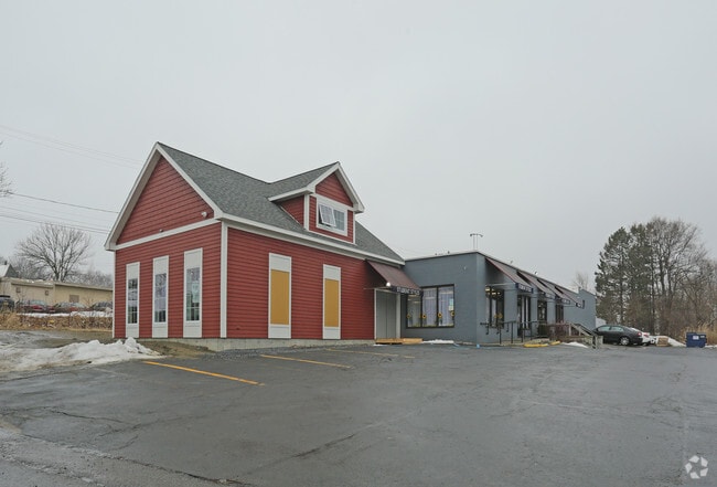
Property Record
15 Cobbee Rd, Latham, NY 12110
NEARBY LISTINGS FOR SALE OR LEASE
Property Detail
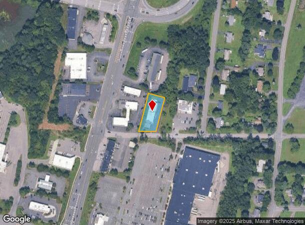
15 Cobbee Rd
Albany-Schenectady-Troy, NY
Town Of Colonie
012689-019-002-0006-014-000-0000
N-905 E-6 C-73-63
Storesoffices
Albany
X
New York
36001C0069D
14.000
2025
0.49 AC
2024
E Outer Albany County
013510
Albany/Schenectady/Troy
5,336 SF
DEMOGRAPHICS near 15 Cobbee Rd
1 Mile
3 Mile
5 Mile
2024 Total Population
5,876
49,901
158,648
2029 Population
5,894
49,651
157,343
Pop Growth 2024-2029
+ 0.31%
(0.50%)
(0.82%)
Average Age
41
41
40
2024 Total Households
2,404
20,134
66,710
HH Growth 2024-2029
+ 0.37%
(0.65%)
(0.92%)
Median Household Inc
$91,644
$81,801
$72,495
Avg Household Size
2.40
2.30
2.20
2024 Avg HH Vehicles
2.00
2.00
2.00
Median Home Value
$286,005
$275,942
$258,561
Median Year Built
1978
1973
1963
Nearby Places
- Restaurants
- Banks
- Shops
- Fitness
- Groceries
PUBLIC TRANSPORTATION
COMMUTER RAIL
DRIVE
WALK
Distance
20 min
9.7 mi
AIRPORT
Albany International
DRIVE
WALK
Distance
Albany International
6 min
2.8 mi
Freight Ports
Albany, NY Port
DRIVE
WALK
Distance
Albany, NY Port
20 min
12.5 mi
Nearby Properties
Address
Land Use
TOTAL SIZE
Lot Size
Zoning
Address
Land Use
TOTAL SIZE
Lot Size
Zoning
821,670 SF
803.50 AC
17
Address
Land Use
TOTAL SIZE
Lot Size
Zoning
18,340 SF
159.79 AC
04 - FARM
Address
Land Use
TOTAL SIZE
Lot Size
Zoning
154,580 SF
89.34 AC
16
Address
Land Use
TOTAL SIZE
Lot Size
Zoning
365,400 SF
73.90 AC
04 - FARM
Address
Land Use
TOTAL SIZE
Lot Size
Zoning
90,316 SF
57.10 AC
04 - FARM
Address
Land Use
TOTAL SIZE
Lot Size
Zoning
226,171 SF
26.39 AC
12
Address
Land Use
TOTAL SIZE
Lot Size
Zoning
242,630 SF
18.50 AC
16
Address
Land Use
TOTAL SIZE
Lot Size
Zoning
18,144 SF
58.78 AC
25
Address
Land Use
TOTAL SIZE
Lot Size
Zoning
84,242 SF
43.60 AC
12
Address
Land Use
TOTAL SIZE
Lot Size
Zoning
501,506 SF
48 AC
01 - NOT Z
Address
Land Use
TOTAL SIZE
Lot Size
Zoning
25,786 SF
8 AC
17
Address
Land Use
TOTAL SIZE
Lot Size
Zoning
223,050 SF
85.68 AC
04 - FARM
Address
Land Use
TOTAL SIZE
Lot Size
Zoning
162,500 SF
19.90 AC
17
Address
Land Use
TOTAL SIZE
Lot Size
Zoning
141,570 SF
4.43 AC
12
Address
Land Use
TOTAL SIZE
Lot Size
Zoning
264,473 SF
26.40 AC
25
Address
Land Use
TOTAL SIZE
Lot Size
Zoning
135,396 SF
19.81 AC
12
Address
Land Use
TOTAL SIZE
Lot Size
Zoning
151,287 SF
11.20 AC
12
Address
Land Use
TOTAL SIZE
Lot Size
Zoning
Address
Land Use
TOTAL SIZE
Lot Size
Zoning
73,736 SF
7.58 AC
14
Address
Land Use
TOTAL SIZE
Lot Size
Zoning
9,792 SF
7.98 AC
R3
Address
Land Use
TOTAL SIZE
Lot Size
Zoning
87,427 SF
20.30 AC
R1A
Address
Land Use
TOTAL SIZE
Lot Size
Zoning
93,373 SF
4.50 AC
02 - SINGL
Address
Land Use
TOTAL SIZE
Lot Size
Zoning
80,891 SF
3.02 AC
04 - FARM
Address
Land Use
TOTAL SIZE
Lot Size
Zoning
14,112 SF
24.70 AC
25
Address
Land Use
TOTAL SIZE
Lot Size
Zoning
53,852 SF
43.35 AC
25
Address
Land Use
TOTAL SIZE
Lot Size
Zoning
159,580 SF
23.20 AC
04 - FARM
Address
Land Use
TOTAL SIZE
Lot Size
Zoning
108,656 SF
6.44 AC
12
Address
Land Use
TOTAL SIZE
Lot Size
Zoning
10,088 SF
30.04 AC
08 - GOVER
Address
Land Use
TOTAL SIZE
Lot Size
Zoning
186,095 SF
14.94 AC
12
Address
Land Use
TOTAL SIZE
Lot Size
Zoning
269,318 SF
7.60 AC
17
The World's #1 Commercial Real Estate Marketplace
Connect with us
© 2025 CoStar Group
The information above has been obtained from sources believed reliable. While we do not doubt its accuracy we have not verified it and make no guarantee, warranty or representation about it. It is your responsibility to independently confirm its accuracy and completeness. Any projections, opinions, assumptions, or estimates used are for example only and do not represent the current or future performance of the property. The value of this transaction to you depends on tax and other factors which should be evaluated by your tax, financial, and legal advisors. You and your advisors should conduct a careful, independent investigation of the property to determine to your satisfaction the suitability of the property for your needs.