Property Record
15 Cronk Rd, Plainville, CT 06062
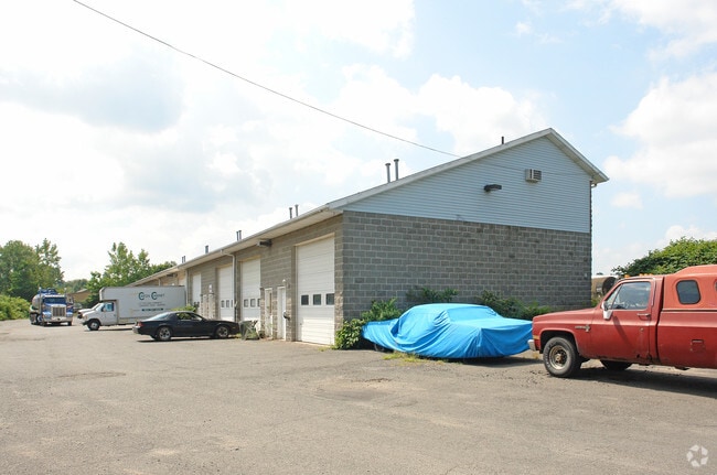

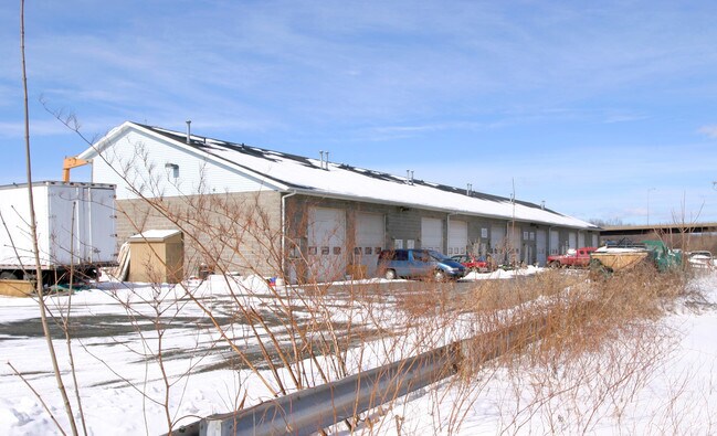
Property Detail
15 Cronk Rd
PLAI-000024-J000000-000004
Capitol
Warehouse
Connecticut
GI
4
AE The base floodplain where base flood elevations are provided. AE Zones are now used on new format FIRMs instead of A1-A30 Zones.
1.17 AC
2025
Plainville
2025
Hartford
420602
Hartford-West Hartford-East Hartford, CT
13,200 SF
NEARBY LISTINGS FOR SALE OR LEASE
DEMOGRAPHICS near 15 Cronk Rd
1 mile
3 mile
5 mile
2025 Total Population
7,997
50,859
160,522
2030 Population
8,149
52,064
163,713
Pop Growth 2025-2030
+ 1.90%
+ 2.37%
+ 1.99%
Average Age
43
43
41
2025 Total Households
3,651
22,191
66,829
HH Growth 2025-2030
+ 1.73%
+ 2.37%
+ 2.04%
Median Household Inc
$80,808
$82,713
$74,743
Avg Household Size
2.10
2.20
2.30
2025 Avg HH Vehicles
2.00
2.00
2.00
Median Home Value
$247,809
$266,368
$283,575
Median Year Built
1963
1969
1963
Nearby Places
Map Layers
Map Styles
 Street
 Aerial
Layers
 Traffic
 Biking
Places
Listings with unknown addresses are not visible on the map
- Restaurants
- Banks
- Shops
- Fitness
- Groceries
PUBLIC TRANSPORTATION
COMMUTER RAIL
Drive
Walk
Distance
14 min
6.9 mi
Drive
Walk
Distance
14 min
6.9 mi
AIRPORT
Bradley International
Drive
Walk
Distance
Bradley International
46 min
29.2 mi
Tweed/New Haven
Drive
Walk
Distance
Tweed/New Haven
49 min
31.7 mi
Freight Ports
Port of New Haven
Drive
Walk
Distance
Port of New Haven
44 min
29.1 mi
SALE & LEASE HISTORY
LISTING DATE
SALE/LEASE

Mar 26, 2020
For Lease
Nearby Properties
Address
Land Use
TOTAL SIZE
Lot Size
Zoning
Address
Land Use
TOTAL SIZE
Lot Size
Zoning
268,369 SF
13.32 AC
B1
Address
Land Use
TOTAL SIZE
Lot Size
Zoning
146,740 SF
18.23 AC
TPC
Address
Land Use
TOTAL SIZE
Lot Size
Zoning
77,001 SF
54.59 AC
IP-1
Address
Land Use
TOTAL SIZE
Lot Size
Zoning
100,304 SF
28.80 AC
IP-1
Address
Land Use
TOTAL SIZE
Lot Size
Zoning
134,488 SF
63.26 AC
GC
Address
Land Use
TOTAL SIZE
Lot Size
Zoning
64,822 SF
9.47 AC
TP
Address
Land Use
TOTAL SIZE
Lot Size
Zoning
137,242 SF
25.80 AC
R40
Address
Land Use
TOTAL SIZE
Lot Size
Zoning
145,719 SF
17.90 AC
R-15
Address
Land Use
TOTAL SIZE
Lot Size
Zoning
114,375 SF
12.72 AC
IP-1
Address
Land Use
TOTAL SIZE
Lot Size
Zoning
330,400 SF
36.90 AC
IP-1
Address
Land Use
TOTAL SIZE
Lot Size
Zoning
182,930 SF
15.70 AC
SA
Address
Land Use
TOTAL SIZE
Lot Size
Zoning
28.47 AC
R-10
Address
Land Use
TOTAL SIZE
Lot Size
Zoning
48.09 AC
CR
Address
Land Use
TOTAL SIZE
Lot Size
Zoning
288,827 SF
24.01 AC
RI
Address
Land Use
TOTAL SIZE
Lot Size
Zoning
103,886 SF
10.47 AC
BR
Address
Land Use
TOTAL SIZE
Lot Size
Zoning
365.02 AC
CR
Address
Land Use
TOTAL SIZE
Lot Size
Zoning
54,904 SF
7.01 AC
A
Address
Land Use
TOTAL SIZE
Lot Size
Zoning
69,025 SF
10.90 AC
S2
Address
Land Use
TOTAL SIZE
Lot Size
Zoning
25.61 AC
RDM
Address
Land Use
TOTAL SIZE
Lot Size
Zoning
502,440 SF
27.87 AC
I-2
Address
Land Use
TOTAL SIZE
Lot Size
Zoning
17.62 AC
B
Address
Land Use
TOTAL SIZE
Lot Size
Zoning
29.05 AC
R-20
Address
Land Use
TOTAL SIZE
Lot Size
Zoning
149,912 SF
13.66 AC
B
Address
Land Use
TOTAL SIZE
Lot Size
Zoning
143,315 SF
4.50 AC
A
Address
Land Use
TOTAL SIZE
Lot Size
Zoning
3,084 SF
14.90 AC
BG
Address
Land Use
TOTAL SIZE
Lot Size
Zoning
19 AC
GI
Address
Land Use
TOTAL SIZE
Lot Size
Zoning
42,516 SF
10.40 AC
BG
Address
Land Use
TOTAL SIZE
Lot Size
Zoning
168,296 SF
17.94 AC
C1
Address
Land Use
TOTAL SIZE
Lot Size
Zoning
41,011 SF
8.50 AC
BG
Address
Land Use
TOTAL SIZE
Lot Size
Zoning
152,042 SF
8.26 AC
TPC
The World's #1 Commercial Real Estate Marketplace
Connect with us
© 2026 CoStar Group
The information above has been obtained from sources believed reliable. While we do not doubt its accuracy we have not verified it and make no guarantee, warranty or representation about it. It is your responsibility to independently confirm its accuracy and completeness. Any projections, opinions, assumptions, or estimates used are for example only and do not represent the current or future performance of the property. The value of this transaction to you depends on tax and other factors which should be evaluated by your tax, financial, and legal advisors. You and your advisors should conduct a careful, independent investigation of the property to determine to your satisfaction the suitability of the property for your needs.