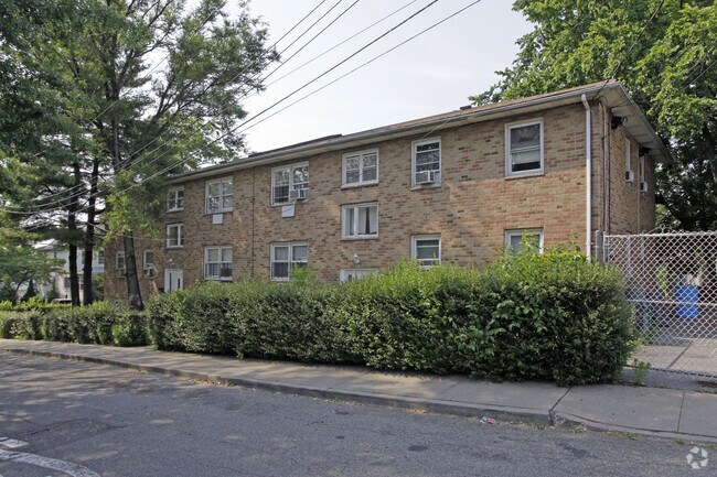
Property Record
15 David Pl, Staten Island, NY 10303

NEARBY LISTINGS FOR SALE OR LEASE
Property Detail
15 David Pl
01166-0001
Staten Island
Transientlodging
New York
X
1
3604970169F
0.23 AC
2024
Mariners Park
2025
Long Island (New York)
023900
New York-Jersey City-White Plains, NY-NJ
4,800 SF
DEMOGRAPHICS near 15 David Pl
1 mile
3 mile
5 mile
2024 Total Population
46,119
215,429
529,220
2029 Population
44,982
209,512
516,857
Pop Growth 2024-2029
(2.47%)
(2.75%)
(2.34%)
Average Age
38
39
40
2024 Total Households
14,586
73,685
184,411
HH Growth 2024-2029
(2.48%)
(2.89%)
(2.41%)
Median Household Inc
$78,019
$78,658
$72,057
Avg Household Size
3.00
2.80
2.80
2024 Avg HH Vehicles
1.00
1.00
1.00
Median Home Value
$471,425
$578,111
$562,396
Median Year Built
1962
1965
1965
Nearby Places
Map Layers
Map Styles
 Street
 Aerial
Transit
 Traffic
 Biking
Places
Listings with unknown addresses are not visible on the map
- Restaurants
- Banks
- Shops
- Fitness
- Groceries
PUBLIC TRANSPORTATION
COMMUTER RAIL
Tompkinsville (Staten Island Railway - New York MTA Subway (The Subway))
Drive
Walk
Distance
Tompkinsville (Staten Island Railway - New York MTA Subway (The Subway))
14 min
4.7 mi
Stapleton (Staten Island Railway - New York MTA Subway (The Subway))
Drive
Walk
Distance
Stapleton (Staten Island Railway - New York MTA Subway (The Subway))
14 min
4.8 mi
AIRPORT
Newark Liberty International
Drive
Walk
Distance
Newark Liberty International
17 min
10.8 mi
LaGuardia
Drive
Walk
Distance
LaGuardia
43 min
25.9 mi
John F Kennedy International
Drive
Walk
Distance
John F Kennedy International
46 min
28.4 mi
Freight Ports
New York Container Terminal
Drive
Walk
Distance
New York Container Terminal
7 min
2.8 mi
Nearby Properties
Address
Land Use
TOTAL SIZE
Lot Size
Zoning
Address
Land Use
TOTAL SIZE
Lot Size
Zoning
28.40 AC
Address
Land Use
TOTAL SIZE
Lot Size
Zoning
633,280 SF
202.90 AC
R3-2
Address
Land Use
TOTAL SIZE
Lot Size
Zoning
98.41 AC
Address
Land Use
TOTAL SIZE
Lot Size
Zoning
4,450,000 SF
95.24 AC
Address
Land Use
TOTAL SIZE
Lot Size
Zoning
22.49 AC
HC
Address
Land Use
TOTAL SIZE
Lot Size
Zoning
686,130 SF
189.62 AC
R3-2
Address
Land Use
TOTAL SIZE
Lot Size
Zoning
70.39 AC
Address
Land Use
TOTAL SIZE
Lot Size
Zoning
16.63 AC
Address
Land Use
TOTAL SIZE
Lot Size
Zoning
2.21 AC
Address
Land Use
TOTAL SIZE
Lot Size
Zoning
1.01 AC
Address
Land Use
TOTAL SIZE
Lot Size
Zoning
51.62 AC
Address
Land Use
TOTAL SIZE
Lot Size
Zoning
91,760 SF
210.43 AC
M3-1
Address
Land Use
TOTAL SIZE
Lot Size
Zoning
Address
Land Use
TOTAL SIZE
Lot Size
Zoning
3,500,000 SF
11.97 AC
MRC2
Address
Land Use
TOTAL SIZE
Lot Size
Zoning
3.27 AC
Address
Land Use
TOTAL SIZE
Lot Size
Zoning
51.61 AC
Address
Land Use
TOTAL SIZE
Lot Size
Zoning
39.64 AC
Address
Land Use
TOTAL SIZE
Lot Size
Zoning
566,000 SF
103.31 AC
R3-2
Address
Land Use
TOTAL SIZE
Lot Size
Zoning
28.47 AC
I-H
Address
Land Use
TOTAL SIZE
Lot Size
Zoning
6,188,000 SF
8.18 AC
Address
Land Use
TOTAL SIZE
Lot Size
Zoning
1 SF
20 AC
Address
Land Use
TOTAL SIZE
Lot Size
Zoning
74.35 AC
TDD
Address
Land Use
TOTAL SIZE
Lot Size
Zoning
30.70 AC
Address
Land Use
TOTAL SIZE
Lot Size
Zoning
855,000 SF
48.74 AC
M3-1
Address
Land Use
TOTAL SIZE
Lot Size
Zoning
28.15 AC
Address
Land Use
TOTAL SIZE
Lot Size
Zoning
10 SF
9.18 AC
Address
Land Use
TOTAL SIZE
Lot Size
Zoning
1,502 SF
0.69 AC
C-1
Address
Land Use
TOTAL SIZE
Lot Size
Zoning
24.19 AC
Address
Land Use
TOTAL SIZE
Lot Size
Zoning
131.25 AC
PARK
Address
Land Use
TOTAL SIZE
Lot Size
Zoning
73.86 AC
IH
The World's #1 Commercial Real Estate Marketplace
Connect with us
© 2026 CoStar Group
The information above has been obtained from sources believed reliable. While we do not doubt its accuracy we have not verified it and make no guarantee, warranty or representation about it. It is your responsibility to independently confirm its accuracy and completeness. Any projections, opinions, assumptions, or estimates used are for example only and do not represent the current or future performance of the property. The value of this transaction to you depends on tax and other factors which should be evaluated by your tax, financial, and legal advisors. You and your advisors should conduct a careful, independent investigation of the property to determine to your satisfaction the suitability of the property for your needs.