Property Record
1 Forest St, Haverhill, NH 03765
Current Lease Availabilities
NEARBY LISTINGS FOR SALE OR LEASE
Property Detail
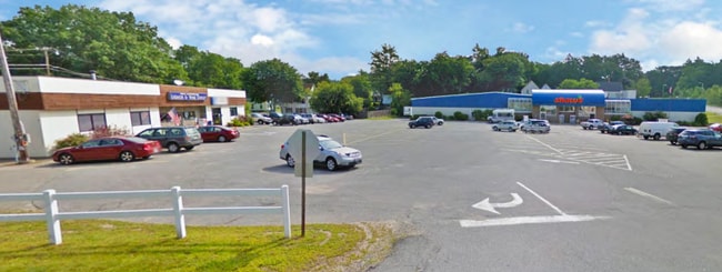
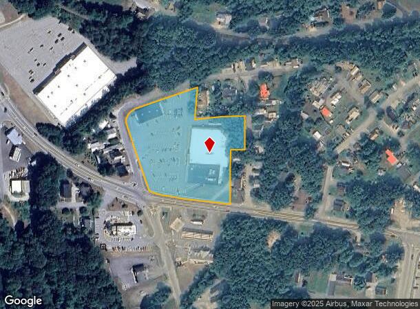
1 Forest St
Commercialnec
Grafton
X
New Hampshire
33009C0220E
3.50 AC
2024
Concord/New Hampshire North Area
2024
Other Market Areas
960600
Claremont-Lebanon, NH-VT
33,948 SF
HVHL-000103-000158
DEMOGRAPHICS near 1 Forest St
1 Mile
3 Mile
5 Mile
2024 Total Population
1,710
2,492
5,255
2029 Population
1,786
2,588
5,466
Pop Growth 2024-2029
+ 4.44%
+ 3.85%
+ 4.02%
Average Age
46
46
46
2024 Total Households
755
1,095
2,292
HH Growth 2024-2029
+ 4.50%
+ 3.84%
+ 3.88%
Median Household Inc
$49,312
$52,147
$56,400
Avg Household Size
2.10
2.20
2.20
2024 Avg HH Vehicles
1.00
2.00
2.00
Median Home Value
$162,831
$173,885
$192,362
Median Year Built
1951
1956
1971
Nearby Places
Map Layers
Map Styles
 Street
 Aerial
- Restaurants
- Banks
- Shops
- Fitness
- Groceries
Nearby Properties
Address
Land Use
TOTAL SIZE
Lot Size
Zoning
Address
Land Use
TOTAL SIZE
Lot Size
Zoning
160,362 SF
21.49 AC
350 WO
Address
Land Use
TOTAL SIZE
Lot Size
Zoning
92,913 SF
9.30 AC
200 OU
Address
Land Use
TOTAL SIZE
Lot Size
Zoning
59,069 SF
12.48 AC
350 WO
Address
Land Use
TOTAL SIZE
Lot Size
Zoning
41,048 SF
10.50 AC
200 OU
Address
Land Use
TOTAL SIZE
Lot Size
Zoning
25,513 SF
10.60 AC
350 WO
Address
Land Use
TOTAL SIZE
Lot Size
Zoning
29,213 SF
7.40 AC
350 WO
Address
Land Use
TOTAL SIZE
Lot Size
Zoning
18,803 SF
26 AC
350 WO
Address
Land Use
TOTAL SIZE
Lot Size
Zoning
1,487 SF
221.80 AC
200 OU
Address
Land Use
TOTAL SIZE
Lot Size
Zoning
63,527 SF
5.70 AC
350 WO
Address
Land Use
TOTAL SIZE
Lot Size
Zoning
22,397 SF
1.92 AC
350 WO
Address
Land Use
TOTAL SIZE
Lot Size
Zoning
11,376 SF
1.79 AC
350 WO
Address
Land Use
TOTAL SIZE
Lot Size
Zoning
5,381 SF
14.10 AC
350 WO
Address
Land Use
TOTAL SIZE
Lot Size
Zoning
34,218 SF
0.36 AC
350 WO
Address
Land Use
TOTAL SIZE
Lot Size
Zoning
3,825 SF
5 AC
350 WO
Address
Land Use
TOTAL SIZE
Lot Size
Zoning
11,718 SF
0.84 AC
350 WO
Address
Land Use
TOTAL SIZE
Lot Size
Zoning
7,386 SF
10.60 AC
350 WO
Address
Land Use
TOTAL SIZE
Lot Size
Zoning
4,613 SF
1.70 AC
350 WO
Address
Land Use
TOTAL SIZE
Lot Size
Zoning
11,018 SF
0.16 AC
350 WO
Address
Land Use
TOTAL SIZE
Lot Size
Zoning
13.70 AC
Address
Land Use
TOTAL SIZE
Lot Size
Zoning
10,300 SF
1.86 AC
200 OU
Address
Land Use
TOTAL SIZE
Lot Size
Zoning
12,226 SF
0.52 AC
350 WO
Address
Land Use
TOTAL SIZE
Lot Size
Zoning
13,580 SF
3.40 AC
350 WO
Address
Land Use
TOTAL SIZE
Lot Size
Zoning
6,417 SF
0.47 AC
350 WO
Address
Land Use
TOTAL SIZE
Lot Size
Zoning
2,381 SF
0.85 AC
350 WO
Address
Land Use
TOTAL SIZE
Lot Size
Zoning
2,570 SF
21.58 AC
CI C
Address
Land Use
TOTAL SIZE
Lot Size
Zoning
17,587 SF
0.25 AC
350 WO
Address
Land Use
TOTAL SIZE
Lot Size
Zoning
6,624 SF
0.87 AC
301 WO
Address
Land Use
TOTAL SIZE
Lot Size
Zoning
4,012 SF
6.40 AC
301 WO
Address
Land Use
TOTAL SIZE
Lot Size
Zoning
14,700 SF
0.10 AC
350 WO
The World's #1 Commercial Real Estate Marketplace
Connect with us
© 2025 CoStar Group
The information above has been obtained from sources believed reliable. While we do not doubt its accuracy we have not verified it and make no guarantee, warranty or representation about it. It is your responsibility to independently confirm its accuracy and completeness. Any projections, opinions, assumptions, or estimates used are for example only and do not represent the current or future performance of the property. The value of this transaction to you depends on tax and other factors which should be evaluated by your tax, financial, and legal advisors. You and your advisors should conduct a careful, independent investigation of the property to determine to your satisfaction the suitability of the property for your needs.