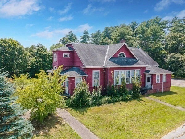
Property Record
15 Gibbs Ave, Wareham, MA 02571

Property Detail
15 Gibbs Ave
WARE-000061-000000-001175
Plymouth
Officebuilding
Massachusetts
B and X Area of moderate flood hazard, usually the area between the limits of the 100-year and 500-year floods.
1175
2025
1.92 AC
2025
Route 3 South
545400
Boston
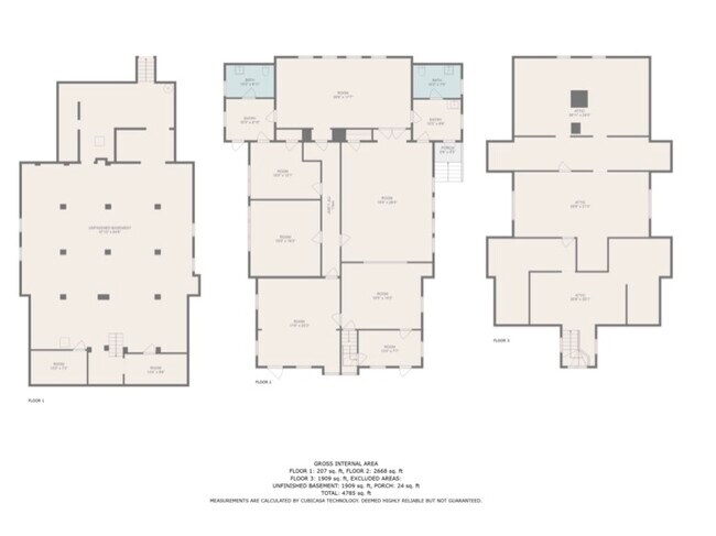
2,716 SF
Boston-Cambridge-Newton, MA-NH
NEARBY LISTINGS FOR SALE OR LEASE
DEMOGRAPHICS near 15 Gibbs Ave
1 mile
3 mile
5 mile
2025 Total Population
2,809
18,704
34,062
2030 Population
2,931
19,571
35,431
Pop Growth 2025-2030
+ 4.34%
+ 4.64%
+ 4.02%
Average Age
45
46
46
2025 Total Households
1,222
8,079
14,477
HH Growth 2025-2030
+ 4.50%
+ 4.78%
+ 4.06%
Median Household Inc
$92,238
$82,724
$90,462
Avg Household Size
2.20
2.20
2.30
2025 Avg HH Vehicles
2.00
2.00
2.00
Median Home Value
$452,371
$443,202
$454,411
Median Year Built
1949
1969
1966
Nearby Places
Map Layers
Map Styles
 Street
 Aerial
Layers
 Traffic
 Biking
Places
Listings with unknown addresses are not visible on the map
- Restaurants
- Banks
- Shops
- Fitness
- Groceries
PUBLIC TRANSPORTATION
COMMUTER RAIL
Drive
Walk
Distance
3 min
17 min
0.9 mi
Drive
Walk
Distance
13 min
6.9 mi
AIRPORT
Martha's Vineyard
Drive
Walk
Distance
Martha's Vineyard
104 min
42.0 mi
Freight Ports
Port of New Bedford Harbor
Drive
Walk
Distance
Port of New Bedford Harbor
24 min
17.1 mi
SALE & LEASE HISTORY
LISTING DATE
SALE/LEASE

Sep 18, 2023
For Sale
Nearby Properties
Address
Land Use
TOTAL SIZE
Lot Size
Zoning
Address
Land Use
TOTAL SIZE
Lot Size
Zoning
163,433 SF
7.47 AC
Address
Land Use
TOTAL SIZE
Lot Size
Zoning
44.75 AC
Address
Land Use
TOTAL SIZE
Lot Size
Zoning
19.86 AC
Address
Land Use
TOTAL SIZE
Lot Size
Zoning
167,599 SF
0.34 AC
Address
Land Use
TOTAL SIZE
Lot Size
Zoning
142,390 SF
5.80 AC
Address
Land Use
TOTAL SIZE
Lot Size
Zoning
93,333 SF
1.19 AC
Address
Land Use
TOTAL SIZE
Lot Size
Zoning
151,614 SF
21.68 AC
Address
Land Use
TOTAL SIZE
Lot Size
Zoning
88,000 SF
12.71 AC
Address
Land Use
TOTAL SIZE
Lot Size
Zoning
68,028 SF
15.56 AC
Address
Land Use
TOTAL SIZE
Lot Size
Zoning
135,083 SF
12.29 AC
Address
Land Use
TOTAL SIZE
Lot Size
Zoning
67,086 SF
6.72 AC
Address
Land Use
TOTAL SIZE
Lot Size
Zoning
12,812 SF
19.12 AC
Address
Land Use
TOTAL SIZE
Lot Size
Zoning
126,525 SF
7.67 AC
Address
Land Use
TOTAL SIZE
Lot Size
Zoning
8.89 AC
Address
Land Use
TOTAL SIZE
Lot Size
Zoning
12.46 AC
Address
Land Use
TOTAL SIZE
Lot Size
Zoning
60.89 AC
Address
Land Use
TOTAL SIZE
Lot Size
Zoning
4,980 SF
16.34 AC
Address
Land Use
TOTAL SIZE
Lot Size
Zoning
62,698 SF
5.63 AC
Address
Land Use
TOTAL SIZE
Lot Size
Zoning
43.44 AC
Address
Land Use
TOTAL SIZE
Lot Size
Zoning
40,392 SF
2.88 AC
Address
Land Use
TOTAL SIZE
Lot Size
Zoning
119,430 SF
8.62 AC
Address
Land Use
TOTAL SIZE
Lot Size
Zoning
Address
Land Use
TOTAL SIZE
Lot Size
Zoning
41,185 SF
14.91 AC
Address
Land Use
TOTAL SIZE
Lot Size
Zoning
5.10 AC
Address
Land Use
TOTAL SIZE
Lot Size
Zoning
65,856 SF
6.70 AC
Address
Land Use
TOTAL SIZE
Lot Size
Zoning
6.30 AC
Address
Land Use
TOTAL SIZE
Lot Size
Zoning
67,000 SF
6.01 AC
Address
Land Use
TOTAL SIZE
Lot Size
Zoning
4.20 AC
Address
Land Use
TOTAL SIZE
Lot Size
Zoning
60,000 SF
1.85 AC
Address
Land Use
TOTAL SIZE
Lot Size
Zoning
31,225 SF
2.50 AC
The World's #1 Commercial Real Estate Marketplace
Connect with us
© 2026 CoStar Group
The information above has been obtained from sources believed reliable. While we do not doubt its accuracy we have not verified it and make no guarantee, warranty or representation about it. It is your responsibility to independently confirm its accuracy and completeness. Any projections, opinions, assumptions, or estimates used are for example only and do not represent the current or future performance of the property. The value of this transaction to you depends on tax and other factors which should be evaluated by your tax, financial, and legal advisors. You and your advisors should conduct a careful, independent investigation of the property to determine to your satisfaction the suitability of the property for your needs.