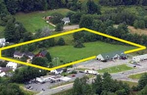
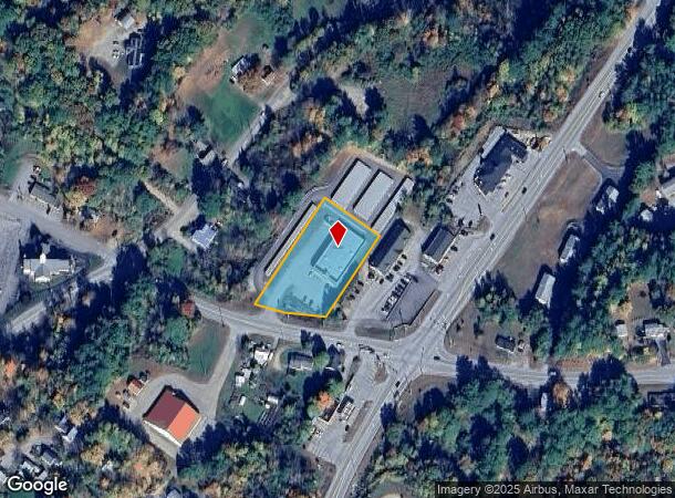
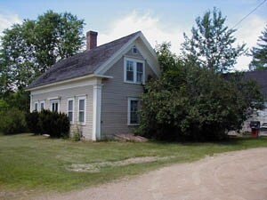
Property Record
15 Gilmanton Rd, Belmont, NH 03220
NEARBY LISTINGS FOR SALE OR LEASE
-
-
View all Belmont listings for sale on LoopNet.com
Property Detail
15 Gilmanton Rd
BLMT-000122-000056
Belknap
Departmentstore
New Hampshire
2024
1.15 AC
2024
Concord/New Hampshire North Area
965802
Other Market Areas
9,150 SF
Laconia, NH
DEMOGRAPHICS near 15 Gilmanton Rd
1 Mile
3 Mile
5 Mile
2024 Total Population
1,372
4,557
12,780
2029 Population
1,387
4,647
13,109
Pop Growth 2024-2029
+ 1.09%
+ 1.97%
+ 2.57%
Average Age
42
43
43
2024 Total Households
546
1,824
5,140
HH Growth 2024-2029
+ 0.73%
+ 1.59%
+ 2.18%
Median Household Inc
$56,666
$68,303
$70,072
Avg Household Size
2.50
2.40
2.40
2024 Avg HH Vehicles
2.00
2.00
2.00
Median Home Value
$190,516
$223,333
$247,876
Median Year Built
1980
1982
1980
Nearby Places
Map Layers
Map Styles
 Street
 Aerial
- Restaurants
- Banks
- Shops
- Fitness
- Groceries
SALE & LEASE HISTORY
LISTING DATE
SALE/LEASE

Sep 24, 2016
For Sale
Nearby Properties
Address
Land Use
TOTAL SIZE
Lot Size
Zoning
Address
Land Use
TOTAL SIZE
Lot Size
Zoning
99,548 SF
36.88 AC
RESM
Address
Land Use
TOTAL SIZE
Lot Size
Zoning
896 SF
9.50 AC
IND
Address
Land Use
TOTAL SIZE
Lot Size
Zoning
31,818 SF
23.86 AC
VIL
Address
Land Use
TOTAL SIZE
Lot Size
Zoning
45,997 SF
55 AC
RESM
Address
Land Use
TOTAL SIZE
Lot Size
Zoning
619 SF
71.80 AC
RESM
Address
Land Use
TOTAL SIZE
Lot Size
Zoning
76,632 SF
7.92 AC
IND
Address
Land Use
TOTAL SIZE
Lot Size
Zoning
2,400 SF
17.41 AC
COM
Address
Land Use
TOTAL SIZE
Lot Size
Zoning
709 SF
175.99 AC
COM
Address
Land Use
TOTAL SIZE
Lot Size
Zoning
1,146 SF
19.40 AC
RESM
Address
Land Use
TOTAL SIZE
Lot Size
Zoning
42,063 SF
19.52 AC
IND
Address
Land Use
TOTAL SIZE
Lot Size
Zoning
6,304 SF
4.79 AC
VIL
Address
Land Use
TOTAL SIZE
Lot Size
Zoning
9.64 AC
COM
Address
Land Use
TOTAL SIZE
Lot Size
Zoning
28,499 SF
23.76 AC
IND
Address
Land Use
TOTAL SIZE
Lot Size
Zoning
9.06 AC
BUS B
Address
Land Use
TOTAL SIZE
Lot Size
Zoning
43,751 SF
3.06 AC
IND
Address
Land Use
TOTAL SIZE
Lot Size
Zoning
4,608 SF
4.50 AC
VIL
Address
Land Use
TOTAL SIZE
Lot Size
Zoning
36,508 SF
6.58 AC
IND
Address
Land Use
TOTAL SIZE
Lot Size
Zoning
21,536 SF
2.01 AC
COM
Address
Land Use
TOTAL SIZE
Lot Size
Zoning
23,108 SF
2.63 AC
COM
Address
Land Use
TOTAL SIZE
Lot Size
Zoning
7,040 SF
5.46 AC
COM
Address
Land Use
TOTAL SIZE
Lot Size
Zoning
6,201 SF
0.78 AC
COM
Address
Land Use
TOTAL SIZE
Lot Size
Zoning
6,444 SF
1.40 AC
VIL
Address
Land Use
TOTAL SIZE
Lot Size
Zoning
7,780 SF
4.60 AC
COM
Address
Land Use
TOTAL SIZE
Lot Size
Zoning
10,611 SF
1.03 AC
VIL
Address
Land Use
TOTAL SIZE
Lot Size
Zoning
4,469 SF
2.94 AC
RESM
Address
Land Use
TOTAL SIZE
Lot Size
Zoning
11,550 SF
5 AC
IND
Address
Land Use
TOTAL SIZE
Lot Size
Zoning
8,000 SF
2.27 AC
IND
Address
Land Use
TOTAL SIZE
Lot Size
Zoning
5,225 SF
3.96 AC
IND
Address
Land Use
TOTAL SIZE
Lot Size
Zoning
15,916 SF
4.94 AC
IND
The World's #1 Commercial Real Estate Marketplace
Connect with us
© 2025 CoStar Group
The information above has been obtained from sources believed reliable. While we do not doubt its accuracy we have not verified it and make no guarantee, warranty or representation about it. It is your responsibility to independently confirm its accuracy and completeness. Any projections, opinions, assumptions, or estimates used are for example only and do not represent the current or future performance of the property. The value of this transaction to you depends on tax and other factors which should be evaluated by your tax, financial, and legal advisors. You and your advisors should conduct a careful, independent investigation of the property to determine to your satisfaction the suitability of the property for your needs.