Property Record
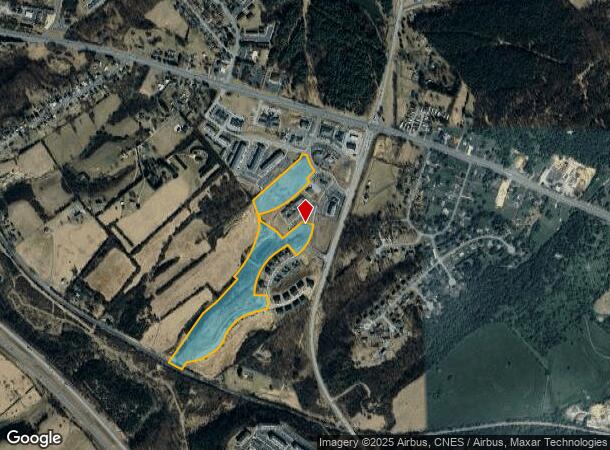
15 Gosnell Xing, Staunton, VA 24401
NEARBY LISTINGS FOR SALE OR LEASE
Property Detail
15 Gosnell Xing
066C-1-2
Wilson
Commercialacreage
66C-(1)-2 ADJ E STAUNTON ON RT 250 23.114 ACS
X
Augusta
51125C0025C
Virginia
2025
23.11 AC
2025
Staunton & Harrisonburg
070602
Other Market Areas
3,955 SF
Staunton-Waynesboro, VA
DEMOGRAPHICS near 15 Gosnell Xing
1 Mile
3 Mile
5 Mile
2024 Total Population
3,320
10,035
29,813
2029 Population
3,522
10,485
30,927
Pop Growth 2024-2029
+ 6.08%
+ 4.48%
+ 3.74%
Average Age
40
42
44
2024 Total Households
1,294
3,926
12,328
HH Growth 2024-2029
+ 6.72%
+ 4.84%
+ 3.85%
Median Household Inc
$50,275
$58,713
$61,453
Avg Household Size
2.30
2.40
2.30
2024 Avg HH Vehicles
2.00
2.00
2.00
Median Home Value
$187,986
$259,783
$264,190
Median Year Built
2008
2003
1992
Nearby Places
- Restaurants
- Banks
- Shops
- Fitness
- Groceries
PUBLIC TRANSPORTATION
COMMUTER RAIL
Staunton Amtrak Station (Cardinal - Amtrak)
DRIVE
WALK
Distance
Staunton Amtrak Station (Cardinal - Amtrak)
10 min
5.5 mi
AIRPORT
Charlottesville-Albemarle
DRIVE
WALK
Distance
Charlottesville-Albemarle
59 min
41.3 mi
Freight Ports
Virginia Port Authority - Richmond
DRIVE
WALK
Distance
Virginia Port Authority - Richmond
130 min
109.4 mi
SALE & LEASE HISTORY
LISTING DATE
SALE/LEASE

Sep 24, 2016
For Sale
Nearby Properties
Address
Land Use
TOTAL SIZE
Lot Size
Zoning
Address
Land Use
TOTAL SIZE
Lot Size
Zoning
35,328 SF
100.10 AC
GENERAL IN
Address
Land Use
TOTAL SIZE
Lot Size
Zoning
422,707 SF
53.88 AC
GENERAL BU
Address
Land Use
TOTAL SIZE
Lot Size
Zoning
103,815 SF
144.63 AC
GENERAL AG
Address
Land Use
TOTAL SIZE
Lot Size
Zoning
17,442 SF
22.14 AC
MULTI-FAMI
Address
Land Use
TOTAL SIZE
Lot Size
Zoning
17,442 SF
7.16 AC
MULTI-FAMI
Address
Land Use
TOTAL SIZE
Lot Size
Zoning
98,326 SF
14.62 AC
GENERAL AG
Address
Land Use
TOTAL SIZE
Lot Size
Zoning
54,796 SF
40 AC
MULTI-FAMI
Address
Land Use
TOTAL SIZE
Lot Size
Zoning
71,141 SF
21.91 AC
GENERAL BU
Address
Land Use
TOTAL SIZE
Lot Size
Zoning
58,660 SF
6.50 AC
GENERAL BU
Address
Land Use
TOTAL SIZE
Lot Size
Zoning
56,516 SF
8.29 AC
GENERAL BU
Address
Land Use
TOTAL SIZE
Lot Size
Zoning
39,748 SF
28.84 AC
GENERAL BU
Address
Land Use
TOTAL SIZE
Lot Size
Zoning
54,507 SF
2.69 AC
B2
Address
Land Use
TOTAL SIZE
Lot Size
Zoning
56,600 SF
18.89 AC
B2
Address
Land Use
TOTAL SIZE
Lot Size
Zoning
44,378 SF
156.80 AC
GENERAL BU
Address
Land Use
TOTAL SIZE
Lot Size
Zoning
48,725 SF
9.21 AC
GENERAL BU
Address
Land Use
TOTAL SIZE
Lot Size
Zoning
41,264 SF
2.70 AC
B2
Address
Land Use
TOTAL SIZE
Lot Size
Zoning
23,826 SF
4.56 AC
GENERAL BU
Address
Land Use
TOTAL SIZE
Lot Size
Zoning
45,129 SF
2.06 AC
GENERAL BU
Address
Land Use
TOTAL SIZE
Lot Size
Zoning
29,520 SF
33.28 AC
GENERAL IN
Address
Land Use
TOTAL SIZE
Lot Size
Zoning
42,343 SF
2.53 AC
GENERAL BU
Address
Land Use
TOTAL SIZE
Lot Size
Zoning
41,603 SF
5.05 AC
GENERAL BU
Address
Land Use
TOTAL SIZE
Lot Size
Zoning
37,080 SF
12 AC
MULTI-FAMI
Address
Land Use
TOTAL SIZE
Lot Size
Zoning
58,706 SF
8.44 AC
GENERAL BU
Address
Land Use
TOTAL SIZE
Lot Size
Zoning
33,665 SF
2.07 AC
GENERAL BU
Address
Land Use
TOTAL SIZE
Lot Size
Zoning
39,896 SF
1.59 AC
GENERAL BU
Address
Land Use
TOTAL SIZE
Lot Size
Zoning
136,214 SF
6.97 AC
GENERAL IN
Address
Land Use
TOTAL SIZE
Lot Size
Zoning
8,450 SF
3.77 AC
MULTI-FAMI
Address
Land Use
TOTAL SIZE
Lot Size
Zoning
2,012 SF
3.92 AC
PLANNED UN
Address
Land Use
TOTAL SIZE
Lot Size
Zoning
1,606 SF
3.24 AC
PLANNED UN
The World's #1 Commercial Real Estate Marketplace
Connect with us
© 2025 CoStar Group
The information above has been obtained from sources believed reliable. While we do not doubt its accuracy we have not verified it and make no guarantee, warranty or representation about it. It is your responsibility to independently confirm its accuracy and completeness. Any projections, opinions, assumptions, or estimates used are for example only and do not represent the current or future performance of the property. The value of this transaction to you depends on tax and other factors which should be evaluated by your tax, financial, and legal advisors. You and your advisors should conduct a careful, independent investigation of the property to determine to your satisfaction the suitability of the property for your needs.