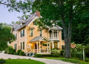
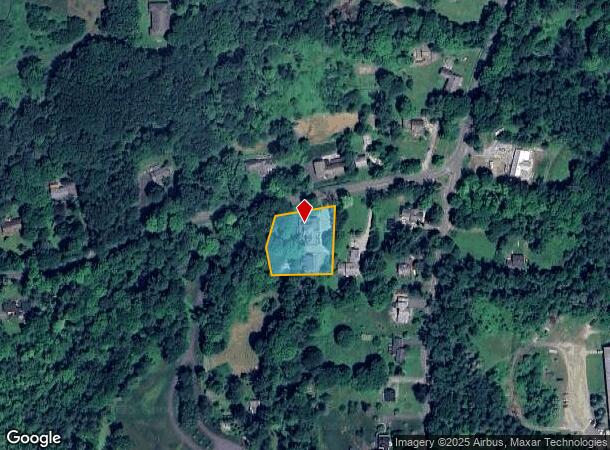
Property Record
15 Hawthorne St, Lenox, MA 01240


NEARBY LISTINGS FOR SALE OR LEASE
-
-
View all Lenox listings for sale on LoopNet.com
Property Detail
15 Hawthorne St
Pittsfield, MA
Berkshire
LENO-000040-000011
Massachusetts
Commercialofficeresidentialmixeduse
0.74 AC
0
Massachusetts North/West Area
2025
Other Market Areas
913100
DEMOGRAPHICS near 15 Hawthorne St
1 Mile
3 Mile
5 Mile
2024 Total Population
1,962
5,740
15,322
2029 Population
1,986
5,816
15,405
Pop Growth 2024-2029
+ 1.22%
+ 1.32%
+ 0.54%
Average Age
56
52
51
2024 Total Households
1,098
2,762
7,100
HH Growth 2024-2029
+ 1.09%
+ 1.34%
+ 0.55%
Median Household Inc
$53,592
$80,638
$74,390
Avg Household Size
1.70
1.90
2.00
2024 Avg HH Vehicles
1.00
2.00
2.00
Median Home Value
$348,507
$388,541
$352,995
Median Year Built
1949
1965
1964
Nearby Places
Map Layers
Map Styles
 Street
 Aerial
- Restaurants
- Banks
- Shops
- Fitness
- Groceries
PUBLIC TRANSPORTATION
COMMUTER RAIL
Pittsfield Amtrak Station (Empire Service - Amtrak, Lake Shore Limited - Amtrak)
DRIVE
WALK
Distance
Pittsfield Amtrak Station (Empire Service - Amtrak, Lake Shore Limited - Amtrak)
15 min
7.3 mi
Freight Ports
Albany, NY Port
DRIVE
WALK
Distance
Albany, NY Port
63 min
44.8 mi
SALE & LEASE HISTORY
LISTING DATE
SALE/LEASE

Dec 03, 2018
For Sale
Nearby Properties
Address
Land Use
TOTAL SIZE
Lot Size
Zoning
Address
Land Use
TOTAL SIZE
Lot Size
Zoning
27,163 SF
43.27 AC
R-1A
Address
Land Use
TOTAL SIZE
Lot Size
Zoning
91.73 AC
R-1A
Address
Land Use
TOTAL SIZE
Lot Size
Zoning
60.39 AC
R-1A
Address
Land Use
TOTAL SIZE
Lot Size
Zoning
94 AC
R4
Address
Land Use
TOTAL SIZE
Lot Size
Zoning
29.60 AC
R-1A
Address
Land Use
TOTAL SIZE
Lot Size
Zoning
99.10 AC
R4
Address
Land Use
TOTAL SIZE
Lot Size
Zoning
87.50 AC
R-1A
Address
Land Use
TOTAL SIZE
Lot Size
Zoning
59,169 SF
10.10 AC
R-1A
Address
Land Use
TOTAL SIZE
Lot Size
Zoning
57,676 SF
6.68 AC
C-3A
Address
Land Use
TOTAL SIZE
Lot Size
Zoning
19,286 SF
32.70 AC
R-1A
Address
Land Use
TOTAL SIZE
Lot Size
Zoning
61,851 SF
13.20 AC
RB
Address
Land Use
TOTAL SIZE
Lot Size
Zoning
86 AC
R4
Address
Land Use
TOTAL SIZE
Lot Size
Zoning
30,003 SF
56 AC
R-1A
Address
Land Use
TOTAL SIZE
Lot Size
Zoning
587.20 AC
R-3A
Address
Land Use
TOTAL SIZE
Lot Size
Zoning
41 AC
R4
Address
Land Use
TOTAL SIZE
Lot Size
Zoning
12.16 AC
R-1A
Address
Land Use
TOTAL SIZE
Lot Size
Zoning
1.90 AC
COMMER
Address
Land Use
TOTAL SIZE
Lot Size
Zoning
469 AC
R-3A
Address
Land Use
TOTAL SIZE
Lot Size
Zoning
48 AC
R-1A
Address
Land Use
TOTAL SIZE
Lot Size
Zoning
49,256 SF
7 AC
RA40
Address
Land Use
TOTAL SIZE
Lot Size
Zoning
26.34 AC
R2
Address
Land Use
TOTAL SIZE
Lot Size
Zoning
12.76 AC
R-1A
Address
Land Use
TOTAL SIZE
Lot Size
Zoning
64,836 SF
11.05 AC
C-3A
Address
Land Use
TOTAL SIZE
Lot Size
Zoning
8,088 SF
41.90 AC
R4
Address
Land Use
TOTAL SIZE
Lot Size
Zoning
27,569 SF
10.40 AC
C-3A
Address
Land Use
TOTAL SIZE
Lot Size
Zoning
38,500 SF
4.80 AC
R-15
Address
Land Use
TOTAL SIZE
Lot Size
Zoning
7.79 AC
R-30
Address
Land Use
TOTAL SIZE
Lot Size
Zoning
18.74 AC
R-1A
Address
Land Use
TOTAL SIZE
Lot Size
Zoning
7.60 AC
R-1A
Address
Land Use
TOTAL SIZE
Lot Size
Zoning
7,136 SF
31.10 AC
C-3A
The World's #1 Commercial Real Estate Marketplace
Connect with us
© 2025 CoStar Group
The information above has been obtained from sources believed reliable. While we do not doubt its accuracy we have not verified it and make no guarantee, warranty or representation about it. It is your responsibility to independently confirm its accuracy and completeness. Any projections, opinions, assumptions, or estimates used are for example only and do not represent the current or future performance of the property. The value of this transaction to you depends on tax and other factors which should be evaluated by your tax, financial, and legal advisors. You and your advisors should conduct a careful, independent investigation of the property to determine to your satisfaction the suitability of the property for your needs.