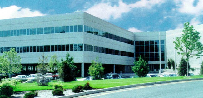
Property Record
15 Hemlock Dr, Congers, NY 10920

NEARBY LISTINGS FOR SALE OR LEASE
-
-
View all Congers listings for sale on LoopNet.com
Property Detail
15 Hemlock Dr
New York-Jersey City-White Plains, NY-NJ
Subdivision Plat Goldkirch Partners
392089-035-020-0001-009-000-0000
GOLDKIRCH PARTNERS LOT 1 129-A-5.6
Warehouse
Rockland
X
New York
36087C0116G
9.0
2023
11 AC
2024
Rockland County
010901
Northern New Jersey
130,930 SF
DEMOGRAPHICS near 15 Hemlock Dr
1 Mile
3 Mile
5 Mile
2024 Total Population
3,651
31,406
132,605
2029 Population
3,619
31,180
130,800
Pop Growth 2024-2029
(0.88%)
(0.72%)
(1.36%)
Average Age
43
42
42
2024 Total Households
1,269
10,395
45,859
HH Growth 2024-2029
(0.95%)
(0.63%)
(1.46%)
Median Household Inc
$123,156
$116,299
$108,326
Avg Household Size
2.80
2.90
2.80
2024 Avg HH Vehicles
2.00
2.00
2.00
Median Home Value
$483,104
$519,236
$494,267
Median Year Built
1979
1970
1967
Nearby Places
Map Layers
Map Styles
 Street
 Aerial
- Restaurants
- Banks
- Shops
- Fitness
- Groceries
PUBLIC TRANSPORTATION
COMMUTER RAIL
Nanuet (Pascack Valley Line - NJ Transit Commuter Rail (NJ Transit))
DRIVE
WALK
Distance
Nanuet (Pascack Valley Line - NJ Transit Commuter Rail (NJ Transit))
14 min
9.0 mi
AIRPORT
Westchester County
DRIVE
WALK
Distance
Westchester County
34 min
24.6 mi
New York Stewart International
DRIVE
WALK
Distance
New York Stewart International
50 min
33.2 mi
LaGuardia
DRIVE
WALK
Distance
LaGuardia
54 min
37.3 mi
Freight Ports
NY - Red Hook Container Terminal
DRIVE
WALK
Distance
NY - Red Hook Container Terminal
65 min
40.5 mi
Nearby Properties
Address
Land Use
TOTAL SIZE
Lot Size
Zoning
Address
Land Use
TOTAL SIZE
Lot Size
Zoning
247,711 SF
37.26 AC
Address
Land Use
TOTAL SIZE
Lot Size
Zoning
94,452 SF
10.71 AC
164
Address
Land Use
TOTAL SIZE
Lot Size
Zoning
Address
Land Use
TOTAL SIZE
Lot Size
Zoning
201.67 AC
Address
Land Use
TOTAL SIZE
Lot Size
Zoning
105,994 SF
2.02 AC
140
Address
Land Use
TOTAL SIZE
Lot Size
Zoning
131,581 SF
2.62 AC
140
Address
Land Use
TOTAL SIZE
Lot Size
Zoning
Address
Land Use
TOTAL SIZE
Lot Size
Zoning
46,164 SF
0.52 AC
168
Address
Land Use
TOTAL SIZE
Lot Size
Zoning
133,039 SF
14.80 AC
CS
Address
Land Use
TOTAL SIZE
Lot Size
Zoning
60,423 SF
2.90 AC
Address
Land Use
TOTAL SIZE
Lot Size
Zoning
129,218 SF
11.56 AC
Address
Land Use
TOTAL SIZE
Lot Size
Zoning
100,800 SF
13.40 AC
02 - SINGL
Address
Land Use
TOTAL SIZE
Lot Size
Zoning
248,709 SF
15.30 AC
Address
Land Use
TOTAL SIZE
Lot Size
Zoning
73,000 SF
5.10 AC
05
Address
Land Use
TOTAL SIZE
Lot Size
Zoning
38,624 SF
5.90 AC
Address
Land Use
TOTAL SIZE
Lot Size
Zoning
52,347 SF
2.56 AC
167
Address
Land Use
TOTAL SIZE
Lot Size
Zoning
99,725 SF
17.78 AC
03 - MULTI
Address
Land Use
TOTAL SIZE
Lot Size
Zoning
57,392 SF
3.40 AC
Address
Land Use
TOTAL SIZE
Lot Size
Zoning
74.45 AC
166
Address
Land Use
TOTAL SIZE
Lot Size
Zoning
4,988 SF
11.80 AC
164
Address
Land Use
TOTAL SIZE
Lot Size
Zoning
28,000 SF
1.70 AC
164
Address
Land Use
TOTAL SIZE
Lot Size
Zoning
35,921 SF
6.10 AC
02 - SINGL
Address
Land Use
TOTAL SIZE
Lot Size
Zoning
214,974 SF
10.80 AC
Address
Land Use
TOTAL SIZE
Lot Size
Zoning
42,948 SF
3.86 AC
Address
Land Use
TOTAL SIZE
Lot Size
Zoning
51,445 SF
12.70 AC
Address
Land Use
TOTAL SIZE
Lot Size
Zoning
111,550 SF
9.29 AC
LI
Address
Land Use
TOTAL SIZE
Lot Size
Zoning
27,768 SF
0.23 AC
130
Address
Land Use
TOTAL SIZE
Lot Size
Zoning
81,780 SF
7.52 AC
Address
Land Use
TOTAL SIZE
Lot Size
Zoning
35 AC
The World's #1 Commercial Real Estate Marketplace
Connect with us
© 2026 CoStar Group
The information above has been obtained from sources believed reliable. While we do not doubt its accuracy we have not verified it and make no guarantee, warranty or representation about it. It is your responsibility to independently confirm its accuracy and completeness. Any projections, opinions, assumptions, or estimates used are for example only and do not represent the current or future performance of the property. The value of this transaction to you depends on tax and other factors which should be evaluated by your tax, financial, and legal advisors. You and your advisors should conduct a careful, independent investigation of the property to determine to your satisfaction the suitability of the property for your needs.