Property Record
15 Hilltop Plz, Kittanning, PA 16201
NEARBY LISTINGS FOR SALE OR LEASE
Property Detail
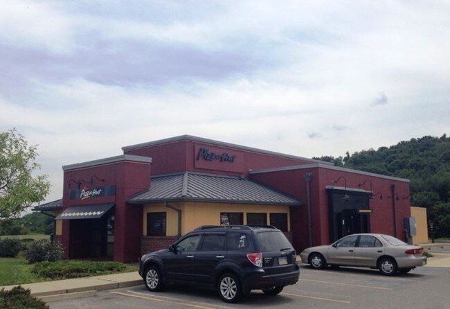
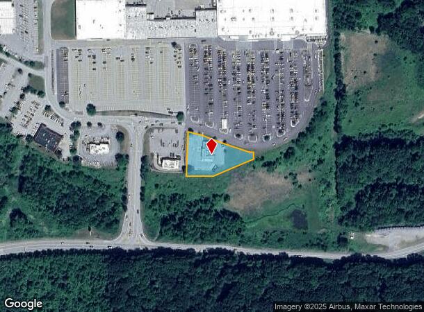
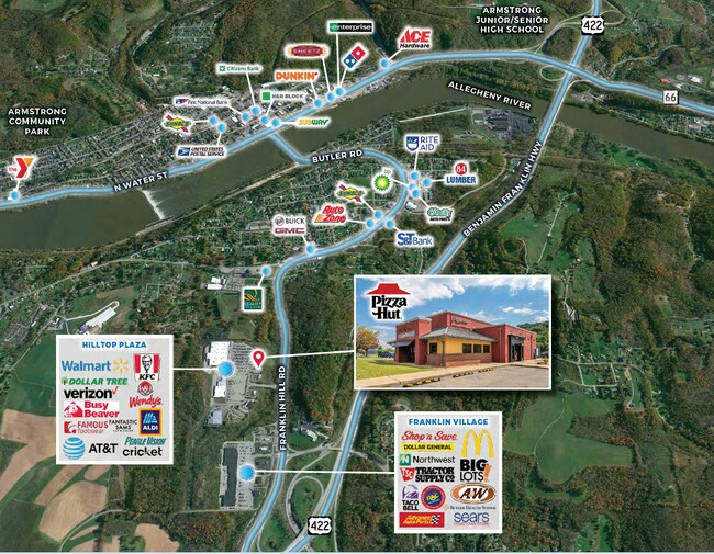
15 Hilltop Plz
12-0-061425
Hilltop Plaza Shopping Center Sub Plan
Restaurantdrivein
0.802A - PIZZA HUT
X
Armstrong
42005C0308D
Pennsylvania
2025
0.80 AC
2025
Armstrong County
950500
Pittsburgh
2,908 SF
Pittsburgh, PA
DEMOGRAPHICS near 15 Hilltop Plz
1 Mile
3 Mile
5 Mile
2024 Total Population
2,026
12,945
21,081
2029 Population
1,980
12,756
20,764
Pop Growth 2024-2029
(2.27%)
(1.46%)
(1.50%)
Average Age
46
44
45
2024 Total Households
921
5,791
9,361
HH Growth 2024-2029
(2.28%)
(1.40%)
(1.48%)
Median Household Inc
$69,121
$53,698
$55,273
Avg Household Size
2.20
2.20
2.20
2024 Avg HH Vehicles
2.00
2.00
2.00
Median Home Value
$144,224
$126,884
$127,674
Median Year Built
1955
1954
1955
Nearby Places
Map Layers
Map Styles
 Street
 Aerial
- Restaurants
- Banks
- Shops
- Fitness
- Groceries
SALE & LEASE HISTORY
LISTING DATE
SALE/LEASE

Sep 06, 2022
For Sale
Nearby Properties
Address
Land Use
TOTAL SIZE
Lot Size
Zoning
Address
Land Use
TOTAL SIZE
Lot Size
Zoning
233,203 SF
9.93 AC
Address
Land Use
TOTAL SIZE
Lot Size
Zoning
260,664 SF
68 AC
Address
Land Use
TOTAL SIZE
Lot Size
Zoning
145,792 SF
13.04 AC
COMMERCIAL
Address
Land Use
TOTAL SIZE
Lot Size
Zoning
37,066 SF
60.59 AC
Address
Land Use
TOTAL SIZE
Lot Size
Zoning
79,630 SF
109.35 AC
RESIDENTIA
Address
Land Use
TOTAL SIZE
Lot Size
Zoning
31,984 SF
0.79 AC
BUSINESS
Address
Land Use
TOTAL SIZE
Lot Size
Zoning
27,200 SF
5.99 AC
INDUSTRIAL
Address
Land Use
TOTAL SIZE
Lot Size
Zoning
96,646 SF
7.90 AC
COMMERCIAL
Address
Land Use
TOTAL SIZE
Lot Size
Zoning
42,795 SF
7.89 AC
INDUSTRIAL
Address
Land Use
TOTAL SIZE
Lot Size
Zoning
113,651 SF
4.49 AC
Address
Land Use
TOTAL SIZE
Lot Size
Zoning
42,238 SF
1.50 AC
PUBLIC
Address
Land Use
TOTAL SIZE
Lot Size
Zoning
31,290 SF
2.93 AC
COMMERCIAL
Address
Land Use
TOTAL SIZE
Lot Size
Zoning
89,326 SF
1.01 AC
PUBLIC
Address
Land Use
TOTAL SIZE
Lot Size
Zoning
72,840 SF
1.08 AC
RESIDENTIA
Address
Land Use
TOTAL SIZE
Lot Size
Zoning
36,441 SF
22.55 AC
COMMERCIAL
Address
Land Use
TOTAL SIZE
Lot Size
Zoning
83,216 SF
1.15 AC
PUBLIC
Address
Land Use
TOTAL SIZE
Lot Size
Zoning
28,431 SF
1.26 AC
Address
Land Use
TOTAL SIZE
Lot Size
Zoning
65,038 SF
0.91 AC
PUBLIC
Address
Land Use
TOTAL SIZE
Lot Size
Zoning
31,104 SF
7.22 AC
Address
Land Use
TOTAL SIZE
Lot Size
Zoning
35,940 SF
24.59 AC
COMMERCIAL
Address
Land Use
TOTAL SIZE
Lot Size
Zoning
13,440 SF
3.68 AC
RESIDENTIA
Address
Land Use
TOTAL SIZE
Lot Size
Zoning
22,792 SF
0.48 AC
COMMERCIAL
Address
Land Use
TOTAL SIZE
Lot Size
Zoning
29,456 SF
3.70 AC
Address
Land Use
TOTAL SIZE
Lot Size
Zoning
14,604 SF
0.78 AC
Address
Land Use
TOTAL SIZE
Lot Size
Zoning
54,048 SF
4 AC
COMMERCIAL
Address
Land Use
TOTAL SIZE
Lot Size
Zoning
12,146 SF
6.87 AC
Address
Land Use
TOTAL SIZE
Lot Size
Zoning
10,788 SF
38.72 AC
Address
Land Use
TOTAL SIZE
Lot Size
Zoning
10.16 AC
Address
Land Use
TOTAL SIZE
Lot Size
Zoning
30,720 SF
1.23 AC
Address
Land Use
TOTAL SIZE
Lot Size
Zoning
51,284 SF
7 AC
INDUSTRIAL
The World's #1 Commercial Real Estate Marketplace
Connect with us
© 2025 CoStar Group
The information above has been obtained from sources believed reliable. While we do not doubt its accuracy we have not verified it and make no guarantee, warranty or representation about it. It is your responsibility to independently confirm its accuracy and completeness. Any projections, opinions, assumptions, or estimates used are for example only and do not represent the current or future performance of the property. The value of this transaction to you depends on tax and other factors which should be evaluated by your tax, financial, and legal advisors. You and your advisors should conduct a careful, independent investigation of the property to determine to your satisfaction the suitability of the property for your needs.