Property Record
15 Iron Rd, Hermon, ME 04401
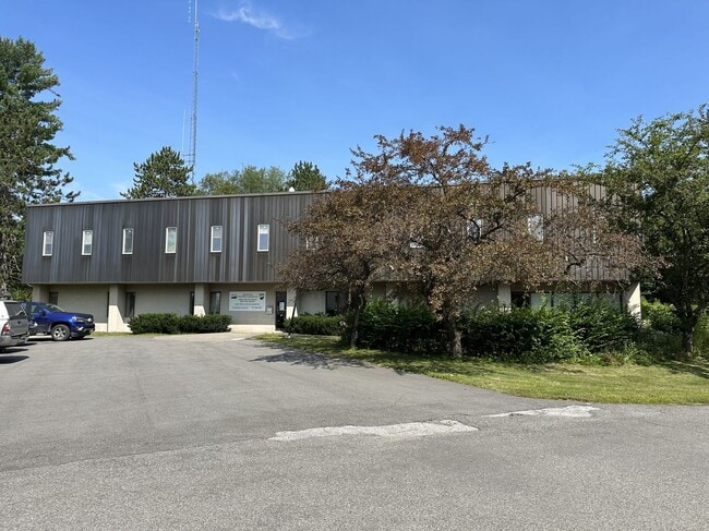

Property Detail
15 Iron Rd
Officebuilding
Penobscot
INDUST
Maine
B and X Area of moderate flood hazard, usually the area between the limits of the 100-year and 500-year floods.
7.52 AC
2025
Maine North & Bangor
2025
Other Market Areas
010000
Bangor, ME
18,788 SF
HERM-000022-000086
NEARBY LISTINGS FOR SALE OR LEASE
-
-
View all Hermon listings for sale on LoopNet.com
DEMOGRAPHICS near 15 Iron Rd
1 mile
3 mile
5 mile
2025 Total Population
431
6,421
44,913
2030 Population
426
6,908
45,859
Pop Growth 2025-2030
(1.16%)
+ 7.58%
+ 2.11%
Average Age
41
43
42
2025 Total Households
188
2,714
19,873
HH Growth 2025-2030
(1.06%)
+ 8.55%
+ 2.17%
Median Household Inc
$72,403
$72,350
$66,553
Avg Household Size
2.30
2.20
2.10
2025 Avg HH Vehicles
2.00
2.00
2.00
Median Home Value
$253,749
$265,277
$260,654
Median Year Built
1992
2006
1968
Nearby Places
Map Layers
Map Styles
 Street
 Aerial
Layers
 Traffic
 Biking
Places
Listings with unknown addresses are not visible on the map
- Restaurants
- Banks
- Shops
- Fitness
- Groceries
PUBLIC TRANSPORTATION
AIRPORT
Bangor International
Drive
Walk
Distance
Bangor International
7 min
2.1 mi
Freight Ports
Searsport, ME
Drive
Walk
Distance
Searsport, ME
52 min
33.9 mi
SALE & LEASE HISTORY
LISTING DATE
SALE/LEASE

Sep 25, 2016
For Lease
Aug 28, 2023
For Sale
Nearby Properties
Address
Land Use
TOTAL SIZE
Lot Size
Zoning
Address
Land Use
TOTAL SIZE
Lot Size
Zoning
466.65 AC
ADD
Address
Land Use
TOTAL SIZE
Lot Size
Zoning
87,750 SF
ADD
Address
Land Use
TOTAL SIZE
Lot Size
Zoning
Address
Land Use
TOTAL SIZE
Lot Size
Zoning
200,000 SF
40 AC
VILLAG
Address
Land Use
TOTAL SIZE
Lot Size
Zoning
144,000 SF
111.04 AC
32 - I
Address
Land Use
TOTAL SIZE
Lot Size
Zoning
13.58 AC
INDUST
Address
Land Use
TOTAL SIZE
Lot Size
Zoning
66,333 SF
5.31 AC
GC&S
Address
Land Use
TOTAL SIZE
Lot Size
Zoning
76,143 SF
1.20 AC
ADD
Address
Land Use
TOTAL SIZE
Lot Size
Zoning
864 SF
28.52 AC
RESIDE
Address
Land Use
TOTAL SIZE
Lot Size
Zoning
18,286 SF
12.48 AC
I&S
Address
Land Use
TOTAL SIZE
Lot Size
Zoning
186,836 SF
24.53 AC
UID
Address
Land Use
TOTAL SIZE
Lot Size
Zoning
134,304 SF
11.12 AC
INDUST
Address
Land Use
TOTAL SIZE
Lot Size
Zoning
12,960 SF
14.20 AC
RESIDE
Address
Land Use
TOTAL SIZE
Lot Size
Zoning
69,562 SF
8 AC
G&ISD
Address
Land Use
TOTAL SIZE
Lot Size
Zoning
4.23 AC
31 - I
Address
Land Use
TOTAL SIZE
Lot Size
Zoning
38,280 SF
13 AC
31 - I
Address
Land Use
TOTAL SIZE
Lot Size
Zoning
64,704 SF
3.27 AC
GC&S
Address
Land Use
TOTAL SIZE
Lot Size
Zoning
45,904 SF
5.86 AC
T&SD
Address
Land Use
TOTAL SIZE
Lot Size
Zoning
162,787 SF
7.09 AC
I&S
Address
Land Use
TOTAL SIZE
Lot Size
Zoning
46,653 SF
3.95 AC
GC&S
Address
Land Use
TOTAL SIZE
Lot Size
Zoning
46,318 SF
6.82 AC
GC&S
Address
Land Use
TOTAL SIZE
Lot Size
Zoning
35,686 SF
4.10 AC
GC&S
Address
Land Use
TOTAL SIZE
Lot Size
Zoning
71,637 SF
4.77 AC
GC&S
Address
Land Use
TOTAL SIZE
Lot Size
Zoning
97,590 SF
11.77 AC
GC&S
Address
Land Use
TOTAL SIZE
Lot Size
Zoning
104,230 SF
10.29 AC
GC&S
Address
Land Use
TOTAL SIZE
Lot Size
Zoning
198 AC
ADD
Address
Land Use
TOTAL SIZE
Lot Size
Zoning
52.50 AC
INDUST
Address
Land Use
TOTAL SIZE
Lot Size
Zoning
32,219 SF
5.61 AC
T&SD
Address
Land Use
TOTAL SIZE
Lot Size
Zoning
2.65 AC
31 - I
Address
Land Use
TOTAL SIZE
Lot Size
Zoning
59,880 SF
6.79 AC
UID
The World's #1 Commercial Real Estate Marketplace
Connect with us
© 2026 CoStar Group
The information above has been obtained from sources believed reliable. While we do not doubt its accuracy we have not verified it and make no guarantee, warranty or representation about it. It is your responsibility to independently confirm its accuracy and completeness. Any projections, opinions, assumptions, or estimates used are for example only and do not represent the current or future performance of the property. The value of this transaction to you depends on tax and other factors which should be evaluated by your tax, financial, and legal advisors. You and your advisors should conduct a careful, independent investigation of the property to determine to your satisfaction the suitability of the property for your needs.