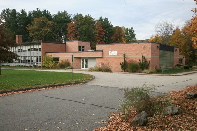
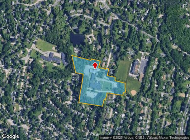
Property Record
15 Jamesbury Dr, Worcester, MA 01609
NEARBY LISTINGS FOR SALE OR LEASE
Property Detail
15 Jamesbury Dr
WORC-000043-000001D-000074
Worcester
Religious
Massachusetts
AE
74
25027C0612E
13.31 AC
0
Worcester Metro
2025
Boston
730801
Worcester, MA-CT
43,015 SF
DEMOGRAPHICS near 15 Jamesbury Dr
1 Mile
3 Mile
5 Mile
2024 Total Population
11,576
134,974
234,626
2029 Population
11,354
132,890
231,794
Pop Growth 2024-2029
(1.92%)
(1.54%)
(1.21%)
Average Age
43
38
39
2024 Total Households
4,489
51,880
90,461
HH Growth 2024-2029
(1.96%)
(1.54%)
(1.20%)
Median Household Inc
$109,911
$54,298
$65,869
Avg Household Size
2.40
2.30
2.40
2024 Avg HH Vehicles
2.00
1.00
2.00
Median Home Value
$396,636
$314,535
$327,062
Median Year Built
1948
1948
1953
Nearby Places
Map Layers
Map Styles
 Street
 Aerial
- Restaurants
- Banks
- Shops
- Fitness
- Groceries
PUBLIC TRANSPORTATION
COMMUTER RAIL
Worcester Union Station (Lake Shore Limited - Amtrak)
DRIVE
WALK
Distance
Worcester Union Station (Lake Shore Limited - Amtrak)
6 min
3.0 mi
Worcester (Framingham/Worcester Line - Massachusetts Bay Transportation Authority Commuter Rail (Purple Line))
DRIVE
WALK
Distance
Worcester (Framingham/Worcester Line - Massachusetts Bay Transportation Authority Commuter Rail (Purple Line))
7 min
3.2 mi
AIRPORT
Worcester Regional
DRIVE
WALK
Distance
Worcester Regional
11 min
4.2 mi
Freight Ports
Port of Boston
DRIVE
WALK
Distance
Port of Boston
67 min
48.0 mi
Nearby Properties
Address
Land Use
TOTAL SIZE
Lot Size
Zoning
Address
Land Use
TOTAL SIZE
Lot Size
Zoning
669,637 SF
17.46 AC
BG-6
Address
Land Use
TOTAL SIZE
Lot Size
Zoning
49.51 AC
IN-S
Address
Land Use
TOTAL SIZE
Lot Size
Zoning
381,440 SF
2.74 AC
BG-6
Address
Land Use
TOTAL SIZE
Lot Size
Zoning
612,538 SF
3.98 AC
BG-6
Address
Land Use
TOTAL SIZE
Lot Size
Zoning
20.01 AC
BG-2
Address
Land Use
TOTAL SIZE
Lot Size
Zoning
155,421 SF
65.04 AC
RL-7
Address
Land Use
TOTAL SIZE
Lot Size
Zoning
524,527 SF
45.16 AC
BL-1
Address
Land Use
TOTAL SIZE
Lot Size
Zoning
51.05 AC
BO-1
Address
Land Use
TOTAL SIZE
Lot Size
Zoning
50.11 AC
RS-7
Address
Land Use
TOTAL SIZE
Lot Size
Zoning
3.85 AC
RG-5
Address
Land Use
TOTAL SIZE
Lot Size
Zoning
117,645 SF
3.11 AC
BO-1
Address
Land Use
TOTAL SIZE
Lot Size
Zoning
311,604 SF
2.37 AC
MG-2
Address
Land Use
TOTAL SIZE
Lot Size
Zoning
272,824 SF
14.95 AC
BL-1
Address
Land Use
TOTAL SIZE
Lot Size
Zoning
16,404 SF
10.80 AC
RS-10
Address
Land Use
TOTAL SIZE
Lot Size
Zoning
1,760 SF
105.54 AC
ML10
Address
Land Use
TOTAL SIZE
Lot Size
Zoning
157,385 SF
3.45 AC
BG-6
Address
Land Use
TOTAL SIZE
Lot Size
Zoning
291,410 SF
21.73 AC
RL-7
Address
Land Use
TOTAL SIZE
Lot Size
Zoning
44,584 SF
90.22 AC
Address
Land Use
TOTAL SIZE
Lot Size
Zoning
15.42 AC
RG-5
Address
Land Use
TOTAL SIZE
Lot Size
Zoning
19,319 SF
10.67 AC
RG-5
Address
Land Use
TOTAL SIZE
Lot Size
Zoning
177.12 AC
RL-7
Address
Land Use
TOTAL SIZE
Lot Size
Zoning
3.55 AC
RG-5
Address
Land Use
TOTAL SIZE
Lot Size
Zoning
194,264 SF
4.32 AC
BL-1
Address
Land Use
TOTAL SIZE
Lot Size
Zoning
68.34 AC
ML10
Address
Land Use
TOTAL SIZE
Lot Size
Zoning
3.43 AC
ML10
Address
Land Use
TOTAL SIZE
Lot Size
Zoning
3.97 AC
BG-6
Address
Land Use
TOTAL SIZE
Lot Size
Zoning
37,093 SF
5.41 AC
RG-5
Address
Land Use
TOTAL SIZE
Lot Size
Zoning
181,408 SF
1.50 AC
BG-6
Address
Land Use
TOTAL SIZE
Lot Size
Zoning
643,250 SF
35.17 AC
RL-7
Address
Land Use
TOTAL SIZE
Lot Size
Zoning
175,200 SF
2.26 AC
BL-1
The World's #1 Commercial Real Estate Marketplace
Connect with us
© 2025 CoStar Group
The information above has been obtained from sources believed reliable. While we do not doubt its accuracy we have not verified it and make no guarantee, warranty or representation about it. It is your responsibility to independently confirm its accuracy and completeness. Any projections, opinions, assumptions, or estimates used are for example only and do not represent the current or future performance of the property. The value of this transaction to you depends on tax and other factors which should be evaluated by your tax, financial, and legal advisors. You and your advisors should conduct a careful, independent investigation of the property to determine to your satisfaction the suitability of the property for your needs.