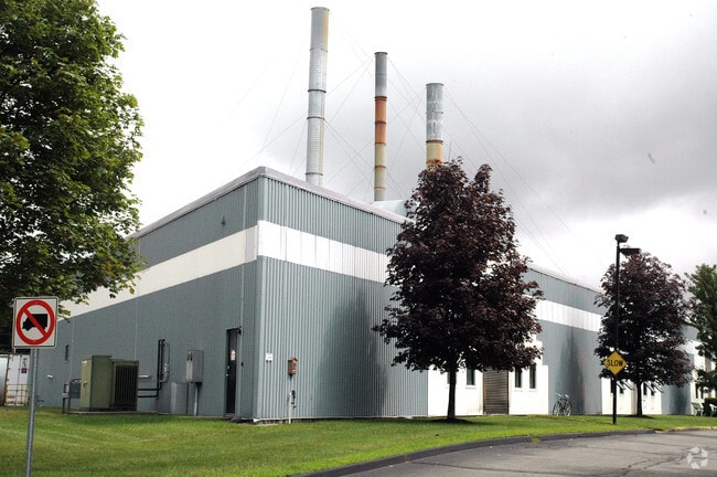
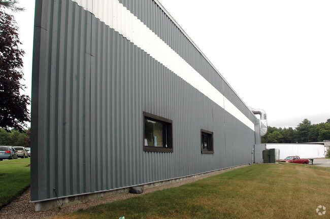
Property Record
15 Kendrick Rd, Wareham, MA 02571

Property Detail
15 Kendrick Rd
WARE-000108-000000-001006N
Plymouth
Manufacturinglight
Massachusetts
B and X Area of moderate flood hazard, usually the area between the limits of the 100-year and 500-year floods.
1006n
2025
3.65 AC
2025
Route 3 South
545100
Boston
37,255 SF
Boston-Cambridge-Newton, MA-NH
NEARBY LISTINGS FOR SALE OR LEASE
DEMOGRAPHICS near 15 Kendrick Rd
1 mile
3 mile
5 mile
2025 Total Population
1,565
13,498
30,188
2030 Population
1,611
14,028
31,328
Pop Growth 2025-2030
+ 2.94%
+ 3.93%
+ 3.78%
Average Age
49
46
45
2025 Total Households
726
5,751
12,673
HH Growth 2025-2030
+ 2.75%
+ 4.02%
+ 3.85%
Median Household Inc
$57,307
$79,091
$87,518
Avg Household Size
2.10
2.30
2.30
2025 Avg HH Vehicles
2.00
2.00
2.00
Median Home Value
$335,975
$441,429
$456,939
Median Year Built
1984
1976
1972
Nearby Places
Map Layers
Map Styles
 Street
 Aerial
Transit
 Traffic
 Biking
Places
Listings with unknown addresses are not visible on the map
- Restaurants
- Banks
- Shops
- Fitness
- Groceries
PUBLIC TRANSPORTATION
COMMUTER RAIL
Wareham Village (CapeFLYER - Cape Cod Regional Transit Authority)
Drive
Walk
Distance
Wareham Village (CapeFLYER - Cape Cod Regional Transit Authority)
6 min
2.6 mi
Buzzards Bay (CapeFLYER - Cape Cod Regional Transit Authority)
Drive
Walk
Distance
Buzzards Bay (CapeFLYER - Cape Cod Regional Transit Authority)
16 min
7.9 mi
AIRPORT
Martha's Vineyard
Drive
Walk
Distance
Martha's Vineyard
105 min
43.1 mi
Freight Ports
Port of New Bedford Harbor
Drive
Walk
Distance
Port of New Bedford Harbor
23 min
16.7 mi
Nearby Properties
Address
Land Use
TOTAL SIZE
Lot Size
Zoning
Address
Land Use
TOTAL SIZE
Lot Size
Zoning
163,433 SF
7.47 AC
Address
Land Use
TOTAL SIZE
Lot Size
Zoning
44.75 AC
Address
Land Use
TOTAL SIZE
Lot Size
Zoning
19.86 AC
Address
Land Use
TOTAL SIZE
Lot Size
Zoning
142,390 SF
5.80 AC
Address
Land Use
TOTAL SIZE
Lot Size
Zoning
93,333 SF
1.19 AC
Address
Land Use
TOTAL SIZE
Lot Size
Zoning
151,614 SF
21.68 AC
Address
Land Use
TOTAL SIZE
Lot Size
Zoning
88,000 SF
12.71 AC
Address
Land Use
TOTAL SIZE
Lot Size
Zoning
95,790 SF
60.72 AC
A/R
Address
Land Use
TOTAL SIZE
Lot Size
Zoning
68,028 SF
15.56 AC
Address
Land Use
TOTAL SIZE
Lot Size
Zoning
135,083 SF
12.29 AC
Address
Land Use
TOTAL SIZE
Lot Size
Zoning
67,086 SF
6.72 AC
Address
Land Use
TOTAL SIZE
Lot Size
Zoning
126,525 SF
7.67 AC
Address
Land Use
TOTAL SIZE
Lot Size
Zoning
12.46 AC
Address
Land Use
TOTAL SIZE
Lot Size
Zoning
4,980 SF
16.34 AC
Address
Land Use
TOTAL SIZE
Lot Size
Zoning
36,492 SF
5.68 AC
Address
Land Use
TOTAL SIZE
Lot Size
Zoning
62,698 SF
5.63 AC
Address
Land Use
TOTAL SIZE
Lot Size
Zoning
43.44 AC
Address
Land Use
TOTAL SIZE
Lot Size
Zoning
40,392 SF
2.88 AC
Address
Land Use
TOTAL SIZE
Lot Size
Zoning
119,430 SF
8.62 AC
Address
Land Use
TOTAL SIZE
Lot Size
Zoning
Address
Land Use
TOTAL SIZE
Lot Size
Zoning
41,185 SF
14.91 AC
Address
Land Use
TOTAL SIZE
Lot Size
Zoning
5.10 AC
Address
Land Use
TOTAL SIZE
Lot Size
Zoning
65,856 SF
6.70 AC
Address
Land Use
TOTAL SIZE
Lot Size
Zoning
6.30 AC
Address
Land Use
TOTAL SIZE
Lot Size
Zoning
67,000 SF
6.01 AC
Address
Land Use
TOTAL SIZE
Lot Size
Zoning
4.20 AC
Address
Land Use
TOTAL SIZE
Lot Size
Zoning
60,000 SF
1.85 AC
Address
Land Use
TOTAL SIZE
Lot Size
Zoning
31,225 SF
2.50 AC
Address
Land Use
TOTAL SIZE
Lot Size
Zoning
2,638 SF
8.90 AC
Address
Land Use
TOTAL SIZE
Lot Size
Zoning
12,080 SF
5.95 AC
The World's #1 Commercial Real Estate Marketplace
Connect with us
© 2026 CoStar Group
The information above has been obtained from sources believed reliable. While we do not doubt its accuracy we have not verified it and make no guarantee, warranty or representation about it. It is your responsibility to independently confirm its accuracy and completeness. Any projections, opinions, assumptions, or estimates used are for example only and do not represent the current or future performance of the property. The value of this transaction to you depends on tax and other factors which should be evaluated by your tax, financial, and legal advisors. You and your advisors should conduct a careful, independent investigation of the property to determine to your satisfaction the suitability of the property for your needs.