Property Record
15 Kenny Roberts Memorial Dr, Suffield, CT 06078

NEARBY LISTINGS FOR SALE OR LEASE
-
-
View all Suffield listings for lease on LoopNet.com
Property Detail
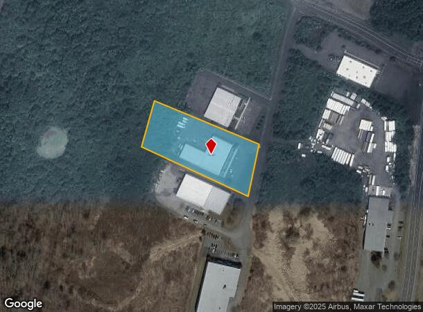
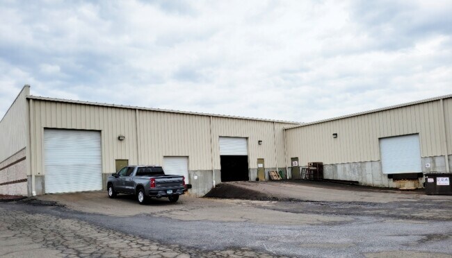
15 Kenny Roberts Memorial Dr
SUFF-000030-000025-000062B
Hartford
Warehouse
Connecticut
X
62b
09003C0208F
2.26 AC
2025
Suffield
2025
Hartford
477101
Hartford-West Hartford-East Hartford, CT
19,530 SF
DEMOGRAPHICS near 15 Kenny Roberts Memorial Dr
1 Mile
3 Mile
5 Mile
2024 Total Population
663
15,936
52,885
2029 Population
647
15,803
52,796
Pop Growth 2024-2029
(2.41%)
(0.83%)
(0.17%)
Average Age
43
43
43
2024 Total Households
269
6,301
21,229
HH Growth 2024-2029
(2.23%)
(1.13%)
(0.32%)
Median Household Inc
$107,500
$90,414
$86,480
Avg Household Size
2.40
2.30
2.30
2024 Avg HH Vehicles
2.00
2.00
2.00
Median Home Value
$384,821
$274,440
$269,387
Median Year Built
1982
1967
1967
Nearby Places
Map Layers
Map Styles
 Street
 Aerial
- Restaurants
- Banks
- Shops
- Fitness
- Groceries
PUBLIC TRANSPORTATION
COMMUTER RAIL
Windsor Locks (Hartford Line - CT Rail (CTRail))
DRIVE
WALK
Distance
Windsor Locks (Hartford Line - CT Rail (CTRail))
11 min
4.4 mi
DRIVE
WALK
Distance
19 min
9.1 mi
AIRPORT
Bradley International
DRIVE
WALK
Distance
Bradley International
12 min
2.6 mi
Freight Ports
Port of New Haven
DRIVE
WALK
Distance
Port of New Haven
75 min
54.9 mi
SALE & LEASE HISTORY
LISTING DATE
SALE/LEASE

Sep 24, 2016
For Lease
Mar 10, 2022
For Lease
Nearby Properties
Address
Land Use
TOTAL SIZE
Lot Size
Zoning
Address
Land Use
TOTAL SIZE
Lot Size
Zoning
723,830 SF
160.79 AC
IND1
Address
Land Use
TOTAL SIZE
Lot Size
Zoning
Address
Land Use
TOTAL SIZE
Lot Size
Zoning
30.30 AC
R25
Address
Land Use
TOTAL SIZE
Lot Size
Zoning
207,981 SF
60.48 AC
R45
Address
Land Use
TOTAL SIZE
Lot Size
Zoning
6,000 SF
62.78 AC
IND1
Address
Land Use
TOTAL SIZE
Lot Size
Zoning
64.41 AC
IND3
Address
Land Use
TOTAL SIZE
Lot Size
Zoning
32.40 AC
R90
Address
Land Use
TOTAL SIZE
Lot Size
Zoning
64,798 SF
1 AC
Address
Land Use
TOTAL SIZE
Lot Size
Zoning
143,800 SF
Address
Land Use
TOTAL SIZE
Lot Size
Zoning
64.46 AC
R25
Address
Land Use
TOTAL SIZE
Lot Size
Zoning
12.14 AC
I
Address
Land Use
TOTAL SIZE
Lot Size
Zoning
124,964 SF
RESA
Address
Land Use
TOTAL SIZE
Lot Size
Zoning
135,228 SF
19.50 AC
R45
Address
Land Use
TOTAL SIZE
Lot Size
Zoning
Address
Land Use
TOTAL SIZE
Lot Size
Zoning
21.50 AC
R25
Address
Land Use
TOTAL SIZE
Lot Size
Zoning
451,937 SF
25.93 AC
IND3
Address
Land Use
TOTAL SIZE
Lot Size
Zoning
14,864 SF
0.25 AC
IND1
Address
Land Use
TOTAL SIZE
Lot Size
Zoning
15.58 AC
RESA
Address
Land Use
TOTAL SIZE
Lot Size
Zoning
50,287 SF
1.74 AC
Address
Land Use
TOTAL SIZE
Lot Size
Zoning
243,624 SF
12.16 AC
I
Address
Land Use
TOTAL SIZE
Lot Size
Zoning
46,206 SF
2.70 AC
BUS1
Address
Land Use
TOTAL SIZE
Lot Size
Zoning
80,408 SF
2.59 AC
BUS1
Address
Land Use
TOTAL SIZE
Lot Size
Zoning
260,002 SF
9.89 AC
IND3
Address
Land Use
TOTAL SIZE
Lot Size
Zoning
Address
Land Use
TOTAL SIZE
Lot Size
Zoning
10 AC
R45
Address
Land Use
TOTAL SIZE
Lot Size
Zoning
38,884 SF
3.04 AC
B1
Address
Land Use
TOTAL SIZE
Lot Size
Zoning
35.52 AC
R25
Address
Land Use
TOTAL SIZE
Lot Size
Zoning
Address
Land Use
TOTAL SIZE
Lot Size
Zoning
62,241 SF
3.21 AC
BUS1
Address
Land Use
TOTAL SIZE
Lot Size
Zoning
4 AC
BUS1
The World's #1 Commercial Real Estate Marketplace
Connect with us
© 2026 CoStar Group
The information above has been obtained from sources believed reliable. While we do not doubt its accuracy we have not verified it and make no guarantee, warranty or representation about it. It is your responsibility to independently confirm its accuracy and completeness. Any projections, opinions, assumptions, or estimates used are for example only and do not represent the current or future performance of the property. The value of this transaction to you depends on tax and other factors which should be evaluated by your tax, financial, and legal advisors. You and your advisors should conduct a careful, independent investigation of the property to determine to your satisfaction the suitability of the property for your needs.