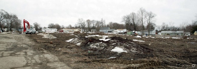
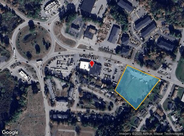
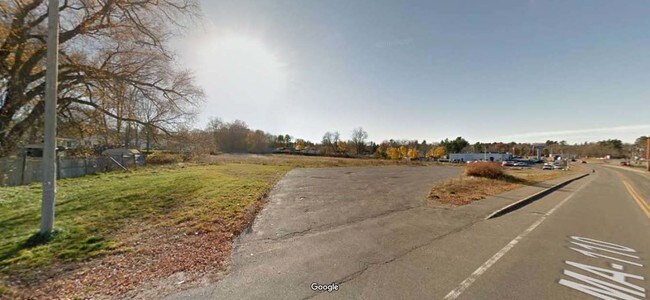
Property Record
5 Littleton Rd, Ayer, MA 01432

Current Lease Availabilities
NEARBY LISTINGS FOR SALE OR LEASE
Property Detail
5 Littleton Rd
AYER-000035-000000-000026
Middlesex
Commercialacreage
Massachusetts
X
26
25027C0312F
2.22 AC
2025
Groton/Townsend
2025
Boston
325101
Boston-Cambridge-Newton, MA-NH
DEMOGRAPHICS near 5 Littleton Rd
1 Mile
3 Mile
5 Mile
2024 Total Population
3,951
14,777
38,789
2029 Population
3,954
14,794
38,597
Pop Growth 2024-2029
+ 0.08%
+ 0.12%
(0.49%)
Average Age
41
43
42
2024 Total Households
1,745
5,522
14,268
HH Growth 2024-2029
(0.17%)
+ 0.11%
(0.51%)
Median Household Inc
$94,054
$121,258
$128,375
Avg Household Size
2.20
2.40
2.50
2024 Avg HH Vehicles
2.00
2.00
2.00
Median Home Value
$380,731
$448,365
$512,753
Median Year Built
1979
1979
1977
Nearby Places
Map Layers
Map Styles
 Street
 Aerial
- Restaurants
- Banks
- Shops
- Fitness
- Groceries
PUBLIC TRANSPORTATION
COMMUTER RAIL
Ayer (Fitchburg/South Acton Line - Massachusetts Bay Transportation Authority Commuter Rail (Purple Line))
DRIVE
WALK
Distance
Ayer (Fitchburg/South Acton Line - Massachusetts Bay Transportation Authority Commuter Rail (Purple Line))
2 min
1.1 mi
Shirley (Fitchburg/South Acton Line - Massachusetts Bay Transportation Authority Commuter Rail (Purple Line))
DRIVE
WALK
Distance
Shirley (Fitchburg/South Acton Line - Massachusetts Bay Transportation Authority Commuter Rail (Purple Line))
9 min
4.5 mi
AIRPORT
Manchester Boston Regional
DRIVE
WALK
Distance
Manchester Boston Regional
57 min
33.3 mi
Worcester Regional
DRIVE
WALK
Distance
Worcester Regional
51 min
37.1 mi
Freight Ports
Port of Boston
DRIVE
WALK
Distance
Port of Boston
57 min
36.6 mi
Nearby Properties
Address
Land Use
TOTAL SIZE
Lot Size
Zoning
Address
Land Use
TOTAL SIZE
Lot Size
Zoning
329,818 SF
55 AC
A1
Address
Land Use
TOTAL SIZE
Lot Size
Zoning
337,563 SF
21.31 AC
17
Address
Land Use
TOTAL SIZE
Lot Size
Zoning
832,622 SF
43.78 AC
I
Address
Land Use
TOTAL SIZE
Lot Size
Zoning
373.10 AC
O
Address
Land Use
TOTAL SIZE
Lot Size
Zoning
51,888 SF
57.38 AC
LI
Address
Land Use
TOTAL SIZE
Lot Size
Zoning
374,270 SF
62.74 AC
IA
Address
Land Use
TOTAL SIZE
Lot Size
Zoning
398,800 SF
21.92 AC
I
Address
Land Use
TOTAL SIZE
Lot Size
Zoning
214.69 AC
O
Address
Land Use
TOTAL SIZE
Lot Size
Zoning
214.32 AC
4
Address
Land Use
TOTAL SIZE
Lot Size
Zoning
202.78 AC
14
Address
Land Use
TOTAL SIZE
Lot Size
Zoning
342,309 SF
21.60 AC
I
Address
Land Use
TOTAL SIZE
Lot Size
Zoning
213,950 SF
22.71 AC
I
Address
Land Use
TOTAL SIZE
Lot Size
Zoning
60,968 SF
Address
Land Use
TOTAL SIZE
Lot Size
Zoning
293,250 SF
60.10 AC
LI
Address
Land Use
TOTAL SIZE
Lot Size
Zoning
343,400 SF
20 AC
LI
Address
Land Use
TOTAL SIZE
Lot Size
Zoning
105,559 SF
35.45 AC
A1
Address
Land Use
TOTAL SIZE
Lot Size
Zoning
142.59 AC
O
Address
Land Use
TOTAL SIZE
Lot Size
Zoning
216,289 SF
17.54 AC
I
Address
Land Use
TOTAL SIZE
Lot Size
Zoning
66,966 SF
C
Address
Land Use
TOTAL SIZE
Lot Size
Zoning
78,344 SF
7.65 AC
O
Address
Land Use
TOTAL SIZE
Lot Size
Zoning
16.44 AC
IA
Address
Land Use
TOTAL SIZE
Lot Size
Zoning
131 AC
2
Address
Land Use
TOTAL SIZE
Lot Size
Zoning
162,000 SF
19.40 AC
I
Address
Land Use
TOTAL SIZE
Lot Size
Zoning
186,000 SF
16.02 AC
C
Address
Land Use
TOTAL SIZE
Lot Size
Zoning
134,920 SF
26.90 AC
I
Address
Land Use
TOTAL SIZE
Lot Size
Zoning
234,465 SF
16.13 AC
I
Address
Land Use
TOTAL SIZE
Lot Size
Zoning
95,148 SF
60.40 AC
16
Address
Land Use
TOTAL SIZE
Lot Size
Zoning
178,900 SF
14.23 AC
14
Address
Land Use
TOTAL SIZE
Lot Size
Zoning
14.90 AC
RA
Address
Land Use
TOTAL SIZE
Lot Size
Zoning
118.55 AC
O
The World's #1 Commercial Real Estate Marketplace
Connect with us
© 2025 CoStar Group
The information above has been obtained from sources believed reliable. While we do not doubt its accuracy we have not verified it and make no guarantee, warranty or representation about it. It is your responsibility to independently confirm its accuracy and completeness. Any projections, opinions, assumptions, or estimates used are for example only and do not represent the current or future performance of the property. The value of this transaction to you depends on tax and other factors which should be evaluated by your tax, financial, and legal advisors. You and your advisors should conduct a careful, independent investigation of the property to determine to your satisfaction the suitability of the property for your needs.