Property Record
15 Long Hill Rd, Bourne, MA 02532

Save to a Folder
{{folder.Name}}
{{folder.ListingIds.length}} Properties
{{folder.ListingIds.length}} Property
Create a New Folder
Property Detail
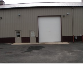
15 Long Hill Rd
BOUR-000480-000093-000002
BARNSTABLE
Commercialcondominium
Massachusetts
B and X Area of moderate flood hazard, usually the area between the limits of the 100-year and 500-year floods.
1.11 AC
2025
Cape Cod
2025
Other Market Areas
013700
Barnstable Town, MA
1,218 SF
NEARBY LISTINGS FOR SALE OR LEASE
DEMOGRAPHICS near 15 Long Hill Rd
1 mile
3 mile
5 mile
2025 Total Population
1,025
7,081
21,697
2030 Population
976
6,760
21,120
Pop Growth 2025-2030
(4.78%)
(4.53%)
(2.66%)
Average Age
50
49
48
2025 Total Households
503
3,086
8,920
HH Growth 2025-2030
(5.17%)
(5.28%)
(2.96%)
Median Household Inc
$80,492
$95,993
$98,466
Avg Household Size
2.00
2.20
2.20
2025 Avg HH Vehicles
2.00
2.00
2.00
Median Home Value
$484,459
$662,672
$652,407
Median Year Built
1981
1977
1978
Nearby Places
Map Layers
Map Styles
 Street
 Aerial
Layers
 Traffic
 Biking
Places
Listings with unknown addresses are not visible on the map
- Restaurants
- Banks
- Shops
- Fitness
- Groceries
PUBLIC TRANSPORTATION
COMMUTER RAIL
Drive
Walk
Distance
8 min
5.0 mi
Drive
Walk
Distance
14 min
8.0 mi
AIRPORT
Martha's Vineyard
Drive
Walk
Distance
Martha's Vineyard
83 min
27.3 mi
Freight Ports
Port of New Bedford Harbor
Drive
Walk
Distance
Port of New Bedford Harbor
43 min
32.3 mi
SALE & LEASE HISTORY
LISTING DATE
SALE/LEASE

May 09, 2022
For Sale
Mar 14, 2019
For Sale
Jun 27, 2023
For Sale
Nearby Properties
Address
Land Use
TOTAL SIZE
Lot Size
Zoning
Address
Land Use
TOTAL SIZE
Lot Size
Zoning
22,000 SF
749.29 AC
GD
Address
Land Use
TOTAL SIZE
Lot Size
Zoning
73,483 SF
16.18 AC
Address
Land Use
TOTAL SIZE
Lot Size
Zoning
11.20 AC
Address
Land Use
TOTAL SIZE
Lot Size
Zoning
5.06 AC
R-80
Address
Land Use
TOTAL SIZE
Lot Size
Zoning
17.50 AC
Address
Land Use
TOTAL SIZE
Lot Size
Zoning
1,199 SF
3.70 AC
R40
Address
Land Use
TOTAL SIZE
Lot Size
Zoning
2.82 AC
Address
Land Use
TOTAL SIZE
Lot Size
Zoning
1,452 SF
6.70 AC
Address
Land Use
TOTAL SIZE
Lot Size
Zoning
57,806 SF
14.39 AC
LIA
Address
Land Use
TOTAL SIZE
Lot Size
Zoning
15.80 AC
Address
Land Use
TOTAL SIZE
Lot Size
Zoning
Address
Land Use
TOTAL SIZE
Lot Size
Zoning
4.10 AC
R-80
Address
Land Use
TOTAL SIZE
Lot Size
Zoning
8.91 AC
R-80
Address
Land Use
TOTAL SIZE
Lot Size
Zoning
3,172 SF
2.23 AC
R40
Address
Land Use
TOTAL SIZE
Lot Size
Zoning
Address
Land Use
TOTAL SIZE
Lot Size
Zoning
1.41 AC
R40
Address
Land Use
TOTAL SIZE
Lot Size
Zoning
10.02 AC
R40
Address
Land Use
TOTAL SIZE
Lot Size
Zoning
5,597 SF
1.37 AC
R40
Address
Land Use
TOTAL SIZE
Lot Size
Zoning
1.56 AC
R40
Address
Land Use
TOTAL SIZE
Lot Size
Zoning
38,800 SF
5.24 AC
B-4
Address
Land Use
TOTAL SIZE
Lot Size
Zoning
5,332 SF
1.55 AC
R40
Address
Land Use
TOTAL SIZE
Lot Size
Zoning
2.70 AC
R40
Address
Land Use
TOTAL SIZE
Lot Size
Zoning
3,429 SF
1.24 AC
R40
Address
Land Use
TOTAL SIZE
Lot Size
Zoning
6,853 SF
4.30 AC
R40
Address
Land Use
TOTAL SIZE
Lot Size
Zoning
118.50 AC
R40
Address
Land Use
TOTAL SIZE
Lot Size
Zoning
6,413 SF
3.23 AC
R40
Address
Land Use
TOTAL SIZE
Lot Size
Zoning
5.18 AC
R-80
Address
Land Use
TOTAL SIZE
Lot Size
Zoning
1,568 SF
1.72 AC
R40
Address
Land Use
TOTAL SIZE
Lot Size
Zoning
1.48 AC
R40
Address
Land Use
TOTAL SIZE
Lot Size
Zoning
7,504 SF
1.15 AC
B-2
The World's #1 Commercial Real Estate Marketplace
Connect with us
© 2026 CoStar Group
The information above has been obtained from sources believed reliable. While we do not doubt its accuracy we have not verified it and make no guarantee, warranty or representation about it. It is your responsibility to independently confirm its accuracy and completeness. Any projections, opinions, assumptions, or estimates used are for example only and do not represent the current or future performance of the property. The value of this transaction to you depends on tax and other factors which should be evaluated by your tax, financial, and legal advisors. You and your advisors should conduct a careful, independent investigation of the property to determine to your satisfaction the suitability of the property for your needs.