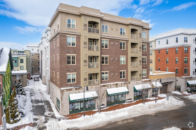
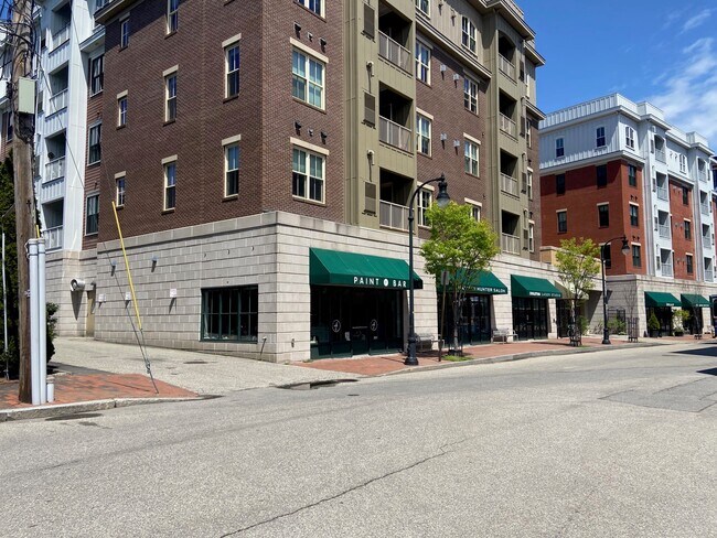
Property Record
22 Hancock St, Portland, ME 04101
NEARBY LISTINGS FOR SALE OR LEASE
Property Detail
22 Hancock St
Officecondo
Cumberland
X
Maine
23005C0711F
East Bayside-India Street
2024
Portland/South Portland
2024
Portland-South Portland, ME
000500
PTLD-000020-000000-E000090C1
980 SF
DEMOGRAPHICS near 22 Hancock St
1 Mile
3 Mile
5 Mile
2024 Total Population
16,251
68,783
108,224
2029 Population
17,021
70,993
111,789
Pop Growth 2024-2029
+ 4.74%
+ 3.21%
+ 3.29%
Average Age
39
41
42
2024 Total Households
8,866
33,365
49,909
HH Growth 2024-2029
+ 4.88%
+ 3.31%
+ 3.43%
Median Household Inc
$55,721
$69,632
$73,919
Avg Household Size
1.70
1.90
2.10
2024 Avg HH Vehicles
1.00
1.00
1.00
Median Home Value
$554,885
$445,977
$421,994
Median Year Built
1948
1948
1954
Nearby Places
Map Layers
Map Styles
 Street
 Aerial
- Restaurants
- Banks
- Shops
- Fitness
- Groceries
PUBLIC TRANSPORTATION
COMMUTER RAIL
Portland (Downeaster - Amtrak)
DRIVE
WALK
Distance
Portland (Downeaster - Amtrak)
5 min
2.6 mi
AIRPORT
Portland International Jetport
DRIVE
WALK
Distance
Portland International Jetport
11 min
4.8 mi
Freight Ports
Portland, ME
DRIVE
WALK
Distance
Portland, ME
1 min
0.6 mi
SALE & LEASE HISTORY
LISTING DATE
SALE/LEASE

Sep 25, 2016
For Lease
Nov 29, 2017
For Lease
Nov 20, 2023
For Sale
May 18, 2023
For Lease
May 18, 2023
For Sale
Aug 10, 2022
For Lease
Nearby Properties
Address
Land Use
TOTAL SIZE
Lot Size
Zoning
Address
Land Use
TOTAL SIZE
Lot Size
Zoning
212.57 AC
Address
Land Use
TOTAL SIZE
Lot Size
Zoning
8.11 AC
Address
Land Use
TOTAL SIZE
Lot Size
Zoning
12.51 AC
Address
Land Use
TOTAL SIZE
Lot Size
Zoning
32.33 AC
Address
Land Use
TOTAL SIZE
Lot Size
Zoning
732,640 SF
Address
Land Use
TOTAL SIZE
Lot Size
Zoning
133,492 SF
27.60 AC
Address
Land Use
TOTAL SIZE
Lot Size
Zoning
114,704 SF
24.60 AC
39
Address
Land Use
TOTAL SIZE
Lot Size
Zoning
7,116 SF
34 AC
WB
Address
Land Use
TOTAL SIZE
Lot Size
Zoning
260,061 SF
1.07 AC
Address
Land Use
TOTAL SIZE
Lot Size
Zoning
24.93 AC
Address
Land Use
TOTAL SIZE
Lot Size
Zoning
103,898 SF
0.66 AC
Address
Land Use
TOTAL SIZE
Lot Size
Zoning
5.13 AC
Address
Land Use
TOTAL SIZE
Lot Size
Zoning
1.12 AC
Address
Land Use
TOTAL SIZE
Lot Size
Zoning
86,510 SF
0.81 AC
Address
Land Use
TOTAL SIZE
Lot Size
Zoning
201,630 SF
0.45 AC
Address
Land Use
TOTAL SIZE
Lot Size
Zoning
130,659 SF
0.78 AC
Address
Land Use
TOTAL SIZE
Lot Size
Zoning
25.75 AC
BON
Address
Land Use
TOTAL SIZE
Lot Size
Zoning
26,584 SF
2.79 AC
Address
Land Use
TOTAL SIZE
Lot Size
Zoning
266,228 SF
2.68 AC
Address
Land Use
TOTAL SIZE
Lot Size
Zoning
238,150 SF
1.37 AC
Address
Land Use
TOTAL SIZE
Lot Size
Zoning
285,570 SF
1.37 AC
Address
Land Use
TOTAL SIZE
Lot Size
Zoning
101,619 SF
0.55 AC
Address
Land Use
TOTAL SIZE
Lot Size
Zoning
1.59 AC
Address
Land Use
TOTAL SIZE
Lot Size
Zoning
10.61 AC
Z
Address
Land Use
TOTAL SIZE
Lot Size
Zoning
181,344 SF
1.62 AC
Address
Land Use
TOTAL SIZE
Lot Size
Zoning
177,118 SF
0.91 AC
Address
Land Use
TOTAL SIZE
Lot Size
Zoning
10.18 AC
Address
Land Use
TOTAL SIZE
Lot Size
Zoning
135,968 SF
7.02 AC
Address
Land Use
TOTAL SIZE
Lot Size
Zoning
157,435 SF
2.28 AC
Address
Land Use
TOTAL SIZE
Lot Size
Zoning
84,627 SF
The World's #1 Commercial Real Estate Marketplace
Connect with us
© 2025 CoStar Group
The information above has been obtained from sources believed reliable. While we do not doubt its accuracy we have not verified it and make no guarantee, warranty or representation about it. It is your responsibility to independently confirm its accuracy and completeness. Any projections, opinions, assumptions, or estimates used are for example only and do not represent the current or future performance of the property. The value of this transaction to you depends on tax and other factors which should be evaluated by your tax, financial, and legal advisors. You and your advisors should conduct a careful, independent investigation of the property to determine to your satisfaction the suitability of the property for your needs.