Property Record
15 Mullen Rd, Enfield, CT 06082
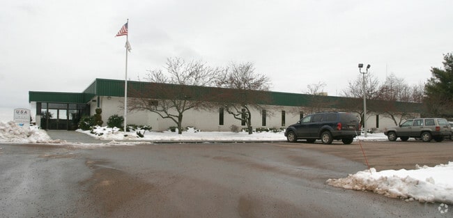

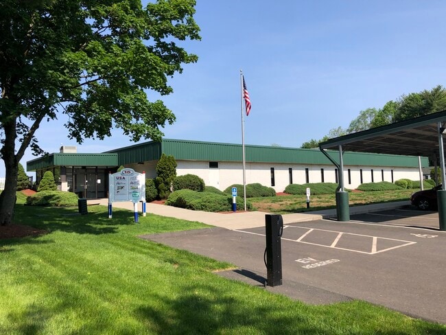
This Property Is For Sale
Current Lease Availabilities
Property Detail
15 Mullen Rd
ENFI-000016-000000-000002
Capitol
Commercialbuilding
Connecticut
I-1
2
B and X Area of moderate flood hazard, usually the area between the limits of the 100-year and 500-year floods.
4.19 AC
2025
Enfield
2025
Hartford
481300
Hartford-West Hartford-East Hartford, CT
13,800 SF
NEARBY LISTINGS FOR SALE OR LEASE
DEMOGRAPHICS near 15 Mullen Rd
1 mile
3 mile
5 mile
2025 Total Population
830
29,061
69,736
2030 Population
843
29,651
71,242
Pop Growth 2025-2030
+ 1.57%
+ 2.03%
+ 2.16%
Average Age
45
43
43
2025 Total Households
351
12,152
28,875
HH Growth 2025-2030
+ 1.71%
+ 2.11%
+ 2.21%
Median Household Inc
$93,749
$91,755
$92,376
Avg Household Size
2.30
2.30
2.30
2025 Avg HH Vehicles
2.00
2.00
2.00
Median Home Value
$284,328
$273,178
$284,786
Median Year Built
1965
1966
1967
Nearby Places
Map Layers
Map Styles
 Street
 Aerial
Layers
 Traffic
 Biking
Places
Listings with unknown addresses are not visible on the map
- Restaurants
- Banks
- Shops
- Fitness
- Groceries
PUBLIC TRANSPORTATION
COMMUTER RAIL
Windsor Locks (Hartford Line - CT Rail (CTRail))
Drive
Walk
Distance
Windsor Locks (Hartford Line - CT Rail (CTRail))
7 min
3.7 mi
Drive
Walk
Distance
15 min
9.3 mi
AIRPORT
Bradley International
Drive
Walk
Distance
Bradley International
23 min
8.7 mi
Nearby Properties
Address
Land Use
TOTAL SIZE
Lot Size
Zoning
Address
Land Use
TOTAL SIZE
Lot Size
Zoning
179,293 SF
51.07 AC
HR33
Address
Land Use
TOTAL SIZE
Lot Size
Zoning
201,978 SF
53.95 AC
R88
Address
Land Use
TOTAL SIZE
Lot Size
Zoning
4,418 SF
106 AC
MFDD
Address
Land Use
TOTAL SIZE
Lot Size
Zoning
176,152 SF
27 AC
R44
Address
Land Use
TOTAL SIZE
Lot Size
Zoning
177,366 SF
61.60 AC
RESA
Address
Land Use
TOTAL SIZE
Lot Size
Zoning
319,054 SF
30.02 AC
I-P
Address
Land Use
TOTAL SIZE
Lot Size
Zoning
190,997 SF
18.47 AC
M-1
Address
Land Use
TOTAL SIZE
Lot Size
Zoning
277,552 SF
40.24 AC
M-1
Address
Land Use
TOTAL SIZE
Lot Size
Zoning
26.82 AC
HR33
Address
Land Use
TOTAL SIZE
Lot Size
Zoning
12.14 AC
I
Address
Land Use
TOTAL SIZE
Lot Size
Zoning
117,699 SF
6.83 AC
MFDD
Address
Land Use
TOTAL SIZE
Lot Size
Zoning
2,867 SF
17.27 AC
R-2
Address
Land Use
TOTAL SIZE
Lot Size
Zoning
124,964 SF
RESA
Address
Land Use
TOTAL SIZE
Lot Size
Zoning
11,952 SF
25 AC
MFDD
Address
Land Use
TOTAL SIZE
Lot Size
Zoning
21.50 AC
R25
Address
Land Use
TOTAL SIZE
Lot Size
Zoning
14,295 SF
24.45 AC
R-1
Address
Land Use
TOTAL SIZE
Lot Size
Zoning
15.58 AC
RESA
Address
Land Use
TOTAL SIZE
Lot Size
Zoning
150,000 SF
22.20 AC
M-1
Address
Land Use
TOTAL SIZE
Lot Size
Zoning
243,624 SF
12.16 AC
I
Address
Land Use
TOTAL SIZE
Lot Size
Zoning
20.54 AC
R33
Address
Land Use
TOTAL SIZE
Lot Size
Zoning
106,851 SF
20.33 AC
R25
Address
Land Use
TOTAL SIZE
Lot Size
Zoning
12 AC
HR33
Address
Land Use
TOTAL SIZE
Lot Size
Zoning
18.04 AC
R33
Address
Land Use
TOTAL SIZE
Lot Size
Zoning
35.52 AC
R25
Address
Land Use
TOTAL SIZE
Lot Size
Zoning
21.97 AC
I-1
Address
Land Use
TOTAL SIZE
Lot Size
Zoning
214,375 SF
3.85 AC
RDRD
Address
Land Use
TOTAL SIZE
Lot Size
Zoning
67,592 SF
7.70 AC
R25
Address
Land Use
TOTAL SIZE
Lot Size
Zoning
7,271 SF
14.43 AC
IND2
Address
Land Use
TOTAL SIZE
Lot Size
Zoning
273,865 SF
39.41 AC
M-1
Address
Land Use
TOTAL SIZE
Lot Size
Zoning
83,541 SF
16.30 AC
M-1
The World's #1 Commercial Real Estate Marketplace
Connect with us
© 2026 CoStar Group
The information above has been obtained from sources believed reliable. While we do not doubt its accuracy we have not verified it and make no guarantee, warranty or representation about it. It is your responsibility to independently confirm its accuracy and completeness. Any projections, opinions, assumptions, or estimates used are for example only and do not represent the current or future performance of the property. The value of this transaction to you depends on tax and other factors which should be evaluated by your tax, financial, and legal advisors. You and your advisors should conduct a careful, independent investigation of the property to determine to your satisfaction the suitability of the property for your needs.