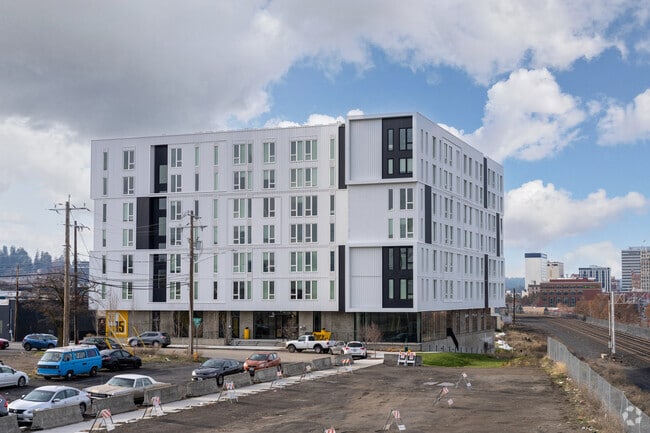
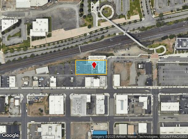
Property Record
15 N Grant St, Spokane, WA 99202

NEARBY LISTINGS FOR SALE OR LEASE
Property Detail
15 N Grant St
Spokane-Spokane Valley, WA
Railroad 1St Add
35173.1323
RAILROAD 1ST ADD TO 3RD BLK5 & 2FT VAC STP E OF&ADJ L 1, TOG/W VAC RIVERSIDE PER ORD# C35883 (AFN6899648) EXC W1/2 LT11 AND LTS 12, 13 & 14
Apartment
Spokane
X
Washington
53063C0542D
1
2025
0.86 AC
2025
U-District
014500
Spokane
68,887 SF
DEMOGRAPHICS near 15 N Grant St
1 Mile
3 Mile
5 Mile
2024 Total Population
14,916
127,402
241,409
2029 Population
15,988
135,703
257,004
Pop Growth 2024-2029
+ 7.19%
+ 6.52%
+ 6.46%
Average Age
37
39
39
2024 Total Households
6,164
54,236
101,276
HH Growth 2024-2029
+ 8.50%
+ 6.92%
+ 6.75%
Median Household Inc
$34,676
$54,875
$58,446
Avg Household Size
1.70
2.20
2.30
2024 Avg HH Vehicles
1.00
2.00
2.00
Median Home Value
$311,054
$312,938
$311,615
Median Year Built
1971
1953
1963
Nearby Places
Map Layers
Map Styles
 Street
 Aerial
- Restaurants
- Banks
- Shops
- Fitness
- Groceries
PUBLIC TRANSPORTATION
COMMUTER RAIL
Spokane (Empire Builder - Amtrak)
DRIVE
WALK
Distance
Spokane (Empire Builder - Amtrak)
2 min
9 min
0.5 mi
AIRPORT
Spokane International
DRIVE
WALK
Distance
Spokane International
12 min
7.0 mi
Freight Ports
Port of Everett
DRIVE
WALK
Distance
Port of Everett
339 min
302.6 mi
SALE & LEASE HISTORY
LISTING DATE
SALE/LEASE

Feb 16, 2022
For Lease
Nearby Properties
Address
Land Use
TOTAL SIZE
Lot Size
Zoning
Address
Land Use
TOTAL SIZE
Lot Size
Zoning
763,627 SF
12.44 AC
OR
Address
Land Use
TOTAL SIZE
Lot Size
Zoning
831,429 SF
119.79 AC
Address
Land Use
TOTAL SIZE
Lot Size
Zoning
481,348 SF
17.09 AC
DTU
Address
Land Use
TOTAL SIZE
Lot Size
Zoning
629,722 SF
26.28 AC
RHD
Address
Land Use
TOTAL SIZE
Lot Size
Zoning
917,113 SF
100.67 AC
LI
Address
Land Use
TOTAL SIZE
Lot Size
Zoning
157,882 SF
42.70 AC
DTG
Address
Land Use
TOTAL SIZE
Lot Size
Zoning
123,047 SF
3.95 AC
DTG
Address
Land Use
TOTAL SIZE
Lot Size
Zoning
241,106 SF
3.92 AC
CB
Address
Land Use
TOTAL SIZE
Lot Size
Zoning
536,438 SF
1.70 AC
DTC
Address
Land Use
TOTAL SIZE
Lot Size
Zoning
365,804 SF
16.13 AC
RSF
Address
Land Use
TOTAL SIZE
Lot Size
Zoning
427,054 SF
16.60 AC
LI
Address
Land Use
TOTAL SIZE
Lot Size
Zoning
154,800 SF
20.06 AC
DTG
Address
Land Use
TOTAL SIZE
Lot Size
Zoning
251,542 SF
5.78 AC
DTG
Address
Land Use
TOTAL SIZE
Lot Size
Zoning
180,822 SF
16.11 AC
CC1
Address
Land Use
TOTAL SIZE
Lot Size
Zoning
107,800 SF
3.20 AC
CB
Address
Land Use
TOTAL SIZE
Lot Size
Zoning
379,678 SF
20.64 AC
LI
Address
Land Use
TOTAL SIZE
Lot Size
Zoning
91,882 SF
2.07 AC
OR
Address
Land Use
TOTAL SIZE
Lot Size
Zoning
124,234 SF
13.54 AC
RSF
Address
Land Use
TOTAL SIZE
Lot Size
Zoning
314,149 SF
1.07 AC
DTC
Address
Land Use
TOTAL SIZE
Lot Size
Zoning
151,667 SF
7.45 AC
DTG
Address
Land Use
TOTAL SIZE
Lot Size
Zoning
289,705 SF
3.36 AC
OR
Address
Land Use
TOTAL SIZE
Lot Size
Zoning
112,634 SF
3.87 AC
OR
Address
Land Use
TOTAL SIZE
Lot Size
Zoning
50,869 SF
0.61 AC
DTC
Address
Land Use
TOTAL SIZE
Lot Size
Zoning
137,503 SF
17.31 AC
GC
Address
Land Use
TOTAL SIZE
Lot Size
Zoning
228,981 SF
5.32 AC
RHD
Address
Land Use
TOTAL SIZE
Lot Size
Zoning
290,380 SF
2.11 AC
CA3
Address
Land Use
TOTAL SIZE
Lot Size
Zoning
182,088 SF
0.37 AC
DTC
Address
Land Use
TOTAL SIZE
Lot Size
Zoning
107,240 SF
1.54 AC
CC1
Address
Land Use
TOTAL SIZE
Lot Size
Zoning
53,748 SF
1.26 AC
DTC
Address
Land Use
TOTAL SIZE
Lot Size
Zoning
289,573 SF
7.73 AC
RMF
The World's #1 Commercial Real Estate Marketplace
Connect with us
© 2025 CoStar Group
The information above has been obtained from sources believed reliable. While we do not doubt its accuracy we have not verified it and make no guarantee, warranty or representation about it. It is your responsibility to independently confirm its accuracy and completeness. Any projections, opinions, assumptions, or estimates used are for example only and do not represent the current or future performance of the property. The value of this transaction to you depends on tax and other factors which should be evaluated by your tax, financial, and legal advisors. You and your advisors should conduct a careful, independent investigation of the property to determine to your satisfaction the suitability of the property for your needs.