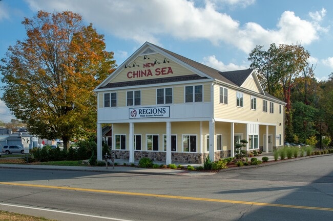
Property Record
15 N Main St, Marlborough, CT 06447
Current Lease Availabilities
NEARBY LISTINGS FOR SALE OR LEASE
Property Detail
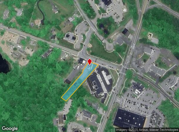
15 N Main St
MARL-000006-000026-000068-000002
Hartford
Commercialofficeresidentialmixeduse
Connecticut
X
68-2
09003C0564F
0.76 AC
2024
Marlborough Outlying
2025
Hartford
524100
Hartford-West Hartford-East Hartford, CT
4,440 SF
DEMOGRAPHICS near 15 N Main St
1 Mile
3 Mile
5 Mile
2024 Total Population
1,714
7,982
22,412
2029 Population
1,703
7,980
22,294
Pop Growth 2024-2029
(0.64%)
(0.03%)
(0.53%)
Average Age
43
43
43
2024 Total Households
667
3,027
8,564
HH Growth 2024-2029
(0.75%)
(0.10%)
(0.64%)
Median Household Inc
$123,263
$124,878
$124,129
Avg Household Size
2.50
2.60
2.60
2024 Avg HH Vehicles
2.00
2.00
2.00
Median Home Value
$356,144
$334,666
$334,957
Median Year Built
1974
1978
1979
Nearby Places
- Restaurants
- Banks
- Shops
- Fitness
- Groceries
PUBLIC TRANSPORTATION
AIRPORT
Bradley International
DRIVE
WALK
Distance
Bradley International
52 min
32.7 mi
Freight Ports
Port of New Haven
DRIVE
WALK
Distance
Port of New Haven
58 min
41.3 mi
Nearby Properties
Address
Land Use
TOTAL SIZE
Lot Size
Zoning
Address
Land Use
TOTAL SIZE
Lot Size
Zoning
12.12 AC
DC
Address
Land Use
TOTAL SIZE
Lot Size
Zoning
81,933 SF
20.65 AC
R
Address
Land Use
TOTAL SIZE
Lot Size
Zoning
17,000 SF
3.98 AC
R-2S
Address
Land Use
TOTAL SIZE
Lot Size
Zoning
16,767 SF
GC
Address
Land Use
TOTAL SIZE
Lot Size
Zoning
16,767 SF
Address
Land Use
TOTAL SIZE
Lot Size
Zoning
36,379 SF
10.98 AC
R
Address
Land Use
TOTAL SIZE
Lot Size
Zoning
25,864 SF
22.90 AC
DMR
Address
Land Use
TOTAL SIZE
Lot Size
Zoning
36.02 AC
R
Address
Land Use
TOTAL SIZE
Lot Size
Zoning
4.79 AC
R
Address
Land Use
TOTAL SIZE
Lot Size
Zoning
8,910 SF
5.71 AC
GC
Address
Land Use
TOTAL SIZE
Lot Size
Zoning
11,442 SF
2.20 AC
GC
Address
Land Use
TOTAL SIZE
Lot Size
Zoning
19,240 SF
4.15 AC
DBIZ5
Address
Land Use
TOTAL SIZE
Lot Size
Zoning
13.50 AC
DGE
Address
Land Use
TOTAL SIZE
Lot Size
Zoning
9,740 SF
1.89 AC
R
Address
Land Use
TOTAL SIZE
Lot Size
Zoning
2.24 AC
Address
Land Use
TOTAL SIZE
Lot Size
Zoning
7,225 SF
1.38 AC
C
Address
Land Use
TOTAL SIZE
Lot Size
Zoning
11,820 SF
7.55 AC
C
Address
Land Use
TOTAL SIZE
Lot Size
Zoning
7,680 SF
2.50 AC
DD
Address
Land Use
TOTAL SIZE
Lot Size
Zoning
9,652 SF
2.37 AC
GC
Address
Land Use
TOTAL SIZE
Lot Size
Zoning
9,000 SF
2.47 AC
GC
Address
Land Use
TOTAL SIZE
Lot Size
Zoning
5,580 SF
4 AC
GC
Address
Land Use
TOTAL SIZE
Lot Size
Zoning
17,510 SF
5.76 AC
DBIZ5
Address
Land Use
TOTAL SIZE
Lot Size
Zoning
6,652 SF
1.87 AC
GC
Address
Land Use
TOTAL SIZE
Lot Size
Zoning
64.25 AC
CR
Address
Land Use
TOTAL SIZE
Lot Size
Zoning
9,648 SF
1.88 AC
GC
Address
Land Use
TOTAL SIZE
Lot Size
Zoning
8,352 SF
1.16 AC
R
Address
Land Use
TOTAL SIZE
Lot Size
Zoning
840 SF
5.74 AC
R
Address
Land Use
TOTAL SIZE
Lot Size
Zoning
7,160 SF
5.40 AC
DRE
Address
Land Use
TOTAL SIZE
Lot Size
Zoning
21,197 SF
4.52 AC
DBIZ
Address
Land Use
TOTAL SIZE
Lot Size
Zoning
15 AC
R-1
The World's #1 Commercial Real Estate Marketplace
Connect with us
© 2025 CoStar Group
The information above has been obtained from sources believed reliable. While we do not doubt its accuracy we have not verified it and make no guarantee, warranty or representation about it. It is your responsibility to independently confirm its accuracy and completeness. Any projections, opinions, assumptions, or estimates used are for example only and do not represent the current or future performance of the property. The value of this transaction to you depends on tax and other factors which should be evaluated by your tax, financial, and legal advisors. You and your advisors should conduct a careful, independent investigation of the property to determine to your satisfaction the suitability of the property for your needs.