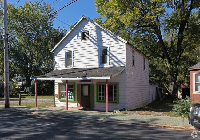
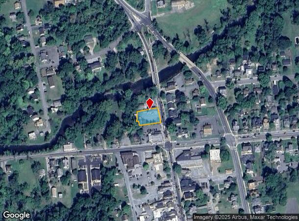
Property Record
15 N Main St, North East, MD 21901


NEARBY LISTINGS FOR SALE OR LEASE
Property Detail
15 N Main St
05-002958
.354 ACRE 15 NORTH MAIN STREET NORTH EAST
Restaurantbuilding
Cecil
AE
Maryland
24015C0152E
0.31 AC
2025
Cecil County
2025
Baltimore
030903
Philadelphia-Camden-Wilmington, PA-NJ-DE-MD
2,512 SF
DEMOGRAPHICS near 15 N Main St
1 Mile
3 Mile
5 Mile
2024 Total Population
6,081
18,358
28,644
2029 Population
6,302
19,070
29,606
Pop Growth 2024-2029
+ 3.63%
+ 3.88%
+ 3.36%
Average Age
38
39
40
2024 Total Households
2,315
7,097
10,892
HH Growth 2024-2029
+ 3.71%
+ 3.96%
+ 3.48%
Median Household Inc
$61,353
$84,794
$85,629
Avg Household Size
2.60
2.60
2.60
2024 Avg HH Vehicles
2.00
2.00
2.00
Median Home Value
$260,557
$300,634
$311,405
Median Year Built
1987
1998
1994
Nearby Places
Map Layers
Map Styles
 Street
 Aerial
- Restaurants
- Banks
- Shops
- Fitness
- Groceries
PUBLIC TRANSPORTATION
COMMUTER RAIL
Perryville (Penn Line - Maryland Area Regional Commuter Trains (The MARC))
DRIVE
WALK
Distance
Perryville (Penn Line - Maryland Area Regional Commuter Trains (The MARC))
14 min
8.6 mi
Freight Ports
Port Newark Container Terminal
DRIVE
WALK
Distance
Port Newark Container Terminal
9 min
4.0 mi
SALE & LEASE HISTORY
LISTING DATE
SALE/LEASE

Oct 11, 2023
For Lease
Feb 10, 2022
For Lease
Nearby Properties
Address
Land Use
TOTAL SIZE
Lot Size
Zoning
Address
Land Use
TOTAL SIZE
Lot Size
Zoning
10,000 SF
50.29 AC
HCHCO
Address
Land Use
TOTAL SIZE
Lot Size
Zoning
593,162 SF
84.15 AC
M2
Address
Land Use
TOTAL SIZE
Lot Size
Zoning
2,397 SF
72.03 AC
M2
Address
Land Use
TOTAL SIZE
Lot Size
Zoning
14,288 SF
67.19 AC
MEA
Address
Land Use
TOTAL SIZE
Lot Size
Zoning
592,800 SF
55.37 AC
M2
Address
Land Use
TOTAL SIZE
Lot Size
Zoning
89,346 SF
21.86 AC
RM
Address
Land Use
TOTAL SIZE
Lot Size
Zoning
28,506 SF
20.23 AC
RM
Address
Land Use
TOTAL SIZE
Lot Size
Zoning
64,000 SF
99.85 AC
ST
Address
Land Use
TOTAL SIZE
Lot Size
Zoning
502,200 SF
50.87 AC
M2
Address
Land Use
TOTAL SIZE
Lot Size
Zoning
193,440 SF
36.74 AC
M1
Address
Land Use
TOTAL SIZE
Lot Size
Zoning
200,100 SF
53.73 AC
Address
Land Use
TOTAL SIZE
Lot Size
Zoning
116,097 SF
64.11 AC
M1
Address
Land Use
TOTAL SIZE
Lot Size
Zoning
9,920 SF
27.68 AC
M1
Address
Land Use
TOTAL SIZE
Lot Size
Zoning
43,634 SF
3.52 AC
I
Address
Land Use
TOTAL SIZE
Lot Size
Zoning
31,344 SF
5.70 AC
RM
Address
Land Use
TOTAL SIZE
Lot Size
Zoning
201,694 SF
18.98 AC
BI
Address
Land Use
TOTAL SIZE
Lot Size
Zoning
69,721 SF
59.50 AC
ST
Address
Land Use
TOTAL SIZE
Lot Size
Zoning
23,800 SF
8.72 AC
BI
Address
Land Use
TOTAL SIZE
Lot Size
Zoning
9,944 SF
98.33 AC
UR
Address
Land Use
TOTAL SIZE
Lot Size
Zoning
121,404 SF
19.65 AC
HC
Address
Land Use
TOTAL SIZE
Lot Size
Zoning
142,582 SF
74 AC
RM
Address
Land Use
TOTAL SIZE
Lot Size
Zoning
4,020 SF
76.79 AC
M2
Address
Land Use
TOTAL SIZE
Lot Size
Zoning
150,000 SF
7.61 AC
M2
Address
Land Use
TOTAL SIZE
Lot Size
Zoning
32,000 SF
193.70 AC
M1
Address
Land Use
TOTAL SIZE
Lot Size
Zoning
60,850 SF
11.75 AC
R1
Address
Land Use
TOTAL SIZE
Lot Size
Zoning
77,905 SF
9.22 AC
I
Address
Land Use
TOTAL SIZE
Lot Size
Zoning
44,138 SF
20.30 AC
Address
Land Use
TOTAL SIZE
Lot Size
Zoning
2,400.63 AC
OS
Address
Land Use
TOTAL SIZE
Lot Size
Zoning
105,041 SF
9.89 AC
R1
Address
Land Use
TOTAL SIZE
Lot Size
Zoning
170.50 AC
BG
The World's #1 Commercial Real Estate Marketplace
Connect with us
© 2025 CoStar Group
The information above has been obtained from sources believed reliable. While we do not doubt its accuracy we have not verified it and make no guarantee, warranty or representation about it. It is your responsibility to independently confirm its accuracy and completeness. Any projections, opinions, assumptions, or estimates used are for example only and do not represent the current or future performance of the property. The value of this transaction to you depends on tax and other factors which should be evaluated by your tax, financial, and legal advisors. You and your advisors should conduct a careful, independent investigation of the property to determine to your satisfaction the suitability of the property for your needs.