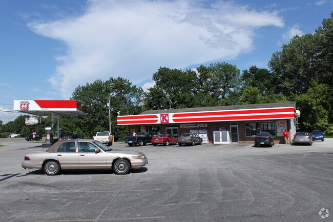
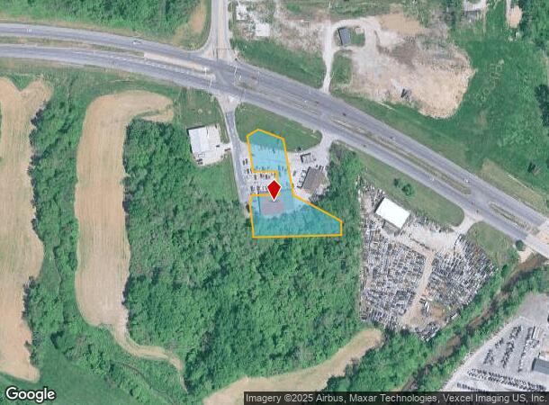
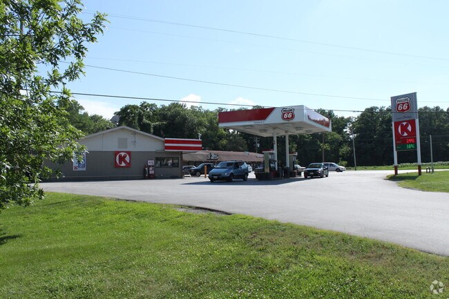
Property Record
15 N Stanley Rd, Cottage Hills, IL 62018
NEARBY LISTINGS FOR SALE OR LEASE
Property Detail
15 N Stanley Rd
St. Louis, MO-IL
PT NW NE EXC AC M/L TO C BRAMLETT EXC 1.26 AC TO STATE
19-1-08-10-02-203-003
Madison
Restaurantbuilding
Illinois
2024
0.87 AC
2024
NE Metro Illinois
401701
St. Louis
7,376 SF
DEMOGRAPHICS near 15 N Stanley Rd
1 Mile
3 Mile
5 Mile
2024 Total Population
2,154
32,939
60,058
2029 Population
2,145
32,602
59,545
Pop Growth 2024-2029
(0.42%)
(1.02%)
(0.85%)
Average Age
41
42
42
2024 Total Households
852
14,156
25,918
HH Growth 2024-2029
(0.47%)
(1.07%)
(0.89%)
Median Household Inc
$56,621
$60,307
$58,028
Avg Household Size
2.40
2.30
2.30
2024 Avg HH Vehicles
2.00
2.00
2.00
Median Home Value
$98,057
$116,732
$117,122
Median Year Built
1964
1958
1958
Nearby Places
Map Layers
Map Styles
 Street
 Aerial
- Restaurants
- Banks
- Shops
- Fitness
- Groceries
PUBLIC TRANSPORTATION
COMMUTER RAIL
Alton Amtrak Station (Lincoln Service - Amtrak, Lincoln Service Missouri River Runner - Amtrak, Texas Eagle - Amtrak)
DRIVE
WALK
Distance
Alton Amtrak Station (Lincoln Service - Amtrak, Lincoln Service Missouri River Runner - Amtrak, Texas Eagle - Amtrak)
9 min
4.9 mi
AIRPORT
St Louis Lambert International
DRIVE
WALK
Distance
St Louis Lambert International
36 min
23.6 mi
Scott AFB/Midamerica St Louis
DRIVE
WALK
Distance
Scott AFB/Midamerica St Louis
57 min
40.5 mi
Freight Ports
Port Milwaukee
DRIVE
WALK
Distance
Port Milwaukee
404 min
353.2 mi
Nearby Properties
Address
Land Use
TOTAL SIZE
Lot Size
Zoning
Address
Land Use
TOTAL SIZE
Lot Size
Zoning
215,635 SF
23.08 AC
Address
Land Use
TOTAL SIZE
Lot Size
Zoning
58,990 SF
11.77 AC
Address
Land Use
TOTAL SIZE
Lot Size
Zoning
147,365 SF
1.91 AC
Address
Land Use
TOTAL SIZE
Lot Size
Zoning
37,533 SF
7.80 AC
Address
Land Use
TOTAL SIZE
Lot Size
Zoning
66,140 SF
9.79 AC
Address
Land Use
TOTAL SIZE
Lot Size
Zoning
58,900 SF
2.05 AC
Address
Land Use
TOTAL SIZE
Lot Size
Zoning
87,624 SF
4.28 AC
Address
Land Use
TOTAL SIZE
Lot Size
Zoning
75,312 SF
4.35 AC
Address
Land Use
TOTAL SIZE
Lot Size
Zoning
20,000 SF
10.81 AC
Address
Land Use
TOTAL SIZE
Lot Size
Zoning
576 SF
16.80 AC
Address
Land Use
TOTAL SIZE
Lot Size
Zoning
64,260 SF
3.90 AC
Address
Land Use
TOTAL SIZE
Lot Size
Zoning
55,020 SF
2.85 AC
Address
Land Use
TOTAL SIZE
Lot Size
Zoning
3,600 SF
59.53 AC
Address
Land Use
TOTAL SIZE
Lot Size
Zoning
29,491 SF
2 AC
Address
Land Use
TOTAL SIZE
Lot Size
Zoning
17,760 SF
2.72 AC
Address
Land Use
TOTAL SIZE
Lot Size
Zoning
26,320 SF
4.82 AC
Address
Land Use
TOTAL SIZE
Lot Size
Zoning
21,614 SF
0.62 AC
Address
Land Use
TOTAL SIZE
Lot Size
Zoning
10,440 SF
1.91 AC
Address
Land Use
TOTAL SIZE
Lot Size
Zoning
89,691 SF
7.78 AC
Address
Land Use
TOTAL SIZE
Lot Size
Zoning
9,000 SF
13.68 AC
Address
Land Use
TOTAL SIZE
Lot Size
Zoning
35,604 SF
0.68 AC
Address
Land Use
TOTAL SIZE
Lot Size
Zoning
41,203 SF
Address
Land Use
TOTAL SIZE
Lot Size
Zoning
80,033 SF
3.66 AC
Address
Land Use
TOTAL SIZE
Lot Size
Zoning
231.92 AC
Address
Land Use
TOTAL SIZE
Lot Size
Zoning
16,816 SF
2.85 AC
Address
Land Use
TOTAL SIZE
Lot Size
Zoning
36,200 SF
4.42 AC
Address
Land Use
TOTAL SIZE
Lot Size
Zoning
Address
Land Use
TOTAL SIZE
Lot Size
Zoning
11,275 SF
2.39 AC
Address
Land Use
TOTAL SIZE
Lot Size
Zoning
297 SF
54.82 AC
Address
Land Use
TOTAL SIZE
Lot Size
Zoning
117,924 SF
28.77 AC
The World's #1 Commercial Real Estate Marketplace
Connect with us
© 2025 CoStar Group
The information above has been obtained from sources believed reliable. While we do not doubt its accuracy we have not verified it and make no guarantee, warranty or representation about it. It is your responsibility to independently confirm its accuracy and completeness. Any projections, opinions, assumptions, or estimates used are for example only and do not represent the current or future performance of the property. The value of this transaction to you depends on tax and other factors which should be evaluated by your tax, financial, and legal advisors. You and your advisors should conduct a careful, independent investigation of the property to determine to your satisfaction the suitability of the property for your needs.