Property Record
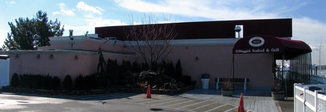
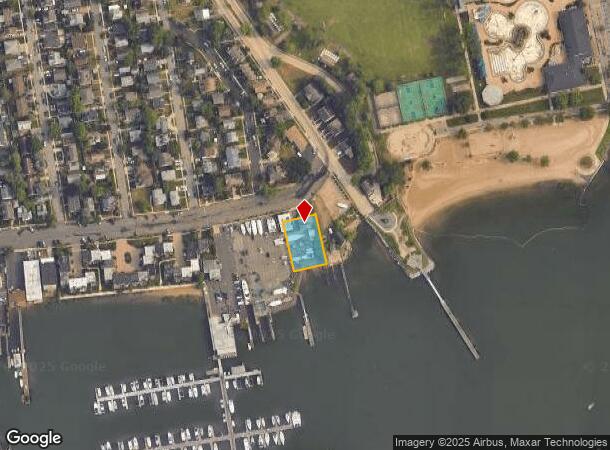
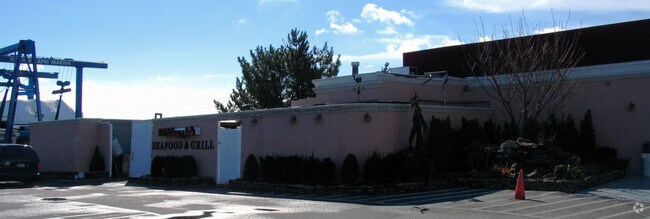
15 Orchard Beach Blvd, Port Washington, NY 11050
NEARBY LISTINGS FOR SALE OR LEASE
Property Detail
15 Orchard Beach Blvd
Nassau County-Suffolk County, NY
Map Of Subdivision Plan Section One Orch
2221-04-059-00-0236-0
TOWN #2 SCH DIST 004
Marinafacility
Nassau
AE
New York
36059C0104G
236
2025
0.35 AC
2025
Western Nassau
301101
Long Island (New York)
7,033 SF
DEMOGRAPHICS near 15 Orchard Beach Blvd
1 Mile
3 Mile
5 Mile
2024 Total Population
10,302
53,970
152,757
2029 Population
10,076
53,242
149,889
Pop Growth 2024-2029
(2.19%)
(1.35%)
(1.88%)
Average Age
42
41
43
2024 Total Households
3,978
18,098
54,590
HH Growth 2024-2029
(1.86%)
(1.37%)
(2.05%)
Median Household Inc
$103,945
$148,268
$126,277
Avg Household Size
2.60
2.90
2.70
2024 Avg HH Vehicles
2.00
2.00
2.00
Median Home Value
$826,227
$992,998
$917,290
Median Year Built
1970
1957
1956
Nearby Places
- Restaurants
- Banks
- Shops
- Fitness
- Groceries
PUBLIC TRANSPORTATION
COMMUTER RAIL
Port Washington Station (Port Washington Branch - Long Island Rail Road)
DRIVE
WALK
Distance
Port Washington Station (Port Washington Branch - Long Island Rail Road)
6 min
2.3 mi
Plandome Station (Port Washington Branch - Long Island Rail Road)
DRIVE
WALK
Distance
Plandome Station (Port Washington Branch - Long Island Rail Road)
8 min
3.7 mi
AIRPORT
LaGuardia
DRIVE
WALK
Distance
LaGuardia
33 min
18.1 mi
John F Kennedy International
DRIVE
WALK
Distance
John F Kennedy International
37 min
21.3 mi
Westchester County
DRIVE
WALK
Distance
Westchester County
62 min
37.3 mi
Freight Ports
NY - Red Hook Container Terminal
DRIVE
WALK
Distance
NY - Red Hook Container Terminal
44 min
26.2 mi
Nearby Properties
Address
Land Use
TOTAL SIZE
Lot Size
Zoning
Address
Land Use
TOTAL SIZE
Lot Size
Zoning
154,748 SF
111.46 AC
R6
Address
Land Use
TOTAL SIZE
Lot Size
Zoning
1,200 SF
177.35 AC
Address
Land Use
TOTAL SIZE
Lot Size
Zoning
251,828 SF
31.03 AC
Address
Land Use
TOTAL SIZE
Lot Size
Zoning
26,200 SF
186 AC
Address
Land Use
TOTAL SIZE
Lot Size
Zoning
196,507 SF
133.37 AC
Address
Land Use
TOTAL SIZE
Lot Size
Zoning
84,302 SF
3.49 AC
Address
Land Use
TOTAL SIZE
Lot Size
Zoning
310,937 SF
12.27 AC
Address
Land Use
TOTAL SIZE
Lot Size
Zoning
98,439 SF
8.94 AC
Address
Land Use
TOTAL SIZE
Lot Size
Zoning
155,256 SF
25 AC
Address
Land Use
TOTAL SIZE
Lot Size
Zoning
56,663 SF
388.75 AC
Address
Land Use
TOTAL SIZE
Lot Size
Zoning
102,595 SF
21.45 AC
Address
Land Use
TOTAL SIZE
Lot Size
Zoning
114,248 SF
80.99 AC
Address
Land Use
TOTAL SIZE
Lot Size
Zoning
52,275 SF
27.63 AC
Address
Land Use
TOTAL SIZE
Lot Size
Zoning
34.05 AC
Address
Land Use
TOTAL SIZE
Lot Size
Zoning
133,941 SF
10.02 AC
Address
Land Use
TOTAL SIZE
Lot Size
Zoning
291,954 SF
21.86 AC
Address
Land Use
TOTAL SIZE
Lot Size
Zoning
95,147 SF
207.90 AC
Address
Land Use
TOTAL SIZE
Lot Size
Zoning
123,240 SF
13.67 AC
Address
Land Use
TOTAL SIZE
Lot Size
Zoning
125,611 SF
11.23 AC
Address
Land Use
TOTAL SIZE
Lot Size
Zoning
19,259 SF
12.22 AC
Address
Land Use
TOTAL SIZE
Lot Size
Zoning
12.35 AC
Address
Land Use
TOTAL SIZE
Lot Size
Zoning
70,230 SF
15.20 AC
Address
Land Use
TOTAL SIZE
Lot Size
Zoning
111,632 SF
3.34 AC
Address
Land Use
TOTAL SIZE
Lot Size
Zoning
81,285 SF
9.99 AC
Address
Land Use
TOTAL SIZE
Lot Size
Zoning
26,798 SF
9.70 AC
Address
Land Use
TOTAL SIZE
Lot Size
Zoning
98,014 SF
7.01 AC
Address
Land Use
TOTAL SIZE
Lot Size
Zoning
3,834 SF
9.89 AC
Address
Land Use
TOTAL SIZE
Lot Size
Zoning
122,650 SF
5.22 AC
Address
Land Use
TOTAL SIZE
Lot Size
Zoning
6,054 SF
18.10 AC
Address
Land Use
TOTAL SIZE
Lot Size
Zoning
14,141 SF
10.50 AC
The World's #1 Commercial Real Estate Marketplace
Connect with us
© 2025 CoStar Group
The information above has been obtained from sources believed reliable. While we do not doubt its accuracy we have not verified it and make no guarantee, warranty or representation about it. It is your responsibility to independently confirm its accuracy and completeness. Any projections, opinions, assumptions, or estimates used are for example only and do not represent the current or future performance of the property. The value of this transaction to you depends on tax and other factors which should be evaluated by your tax, financial, and legal advisors. You and your advisors should conduct a careful, independent investigation of the property to determine to your satisfaction the suitability of the property for your needs.