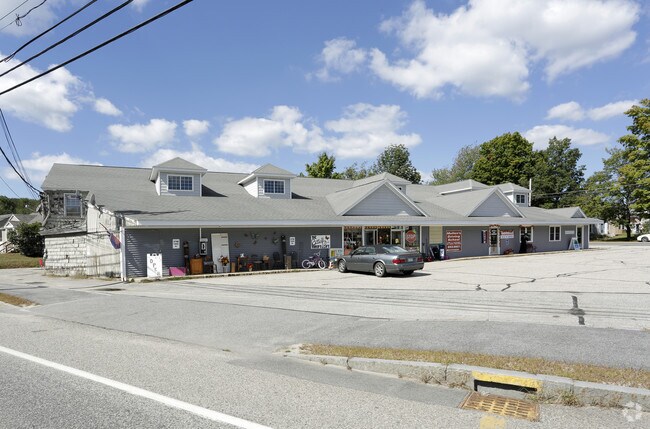
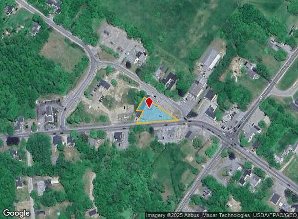
Property Record
15 Ossipee Trl W, Standish, ME 04084

NEARBY LISTINGS FOR SALE OR LEASE
Property Detail
15 Ossipee Trl W
STAN-000036-000000-000008
Cumberland
Departmentstore
Maine
X
8
23031C0160G
0.60 AC
2024
SW Cumberland County
2024
Portland/South Portland
017003
Portland-South Portland, ME
11,672 SF
DEMOGRAPHICS near 15 Ossipee Trl W
1 Mile
3 Mile
5 Mile
2024 Total Population
677
5,713
13,634
2029 Population
685
5,883
14,057
Pop Growth 2024-2029
+ 1.18%
+ 2.98%
+ 3.10%
Average Age
43
42
41
2024 Total Households
290
2,244
5,231
HH Growth 2024-2029
+ 1.03%
+ 2.99%
+ 3.12%
Median Household Inc
$52,381
$78,996
$85,629
Avg Household Size
2.40
2.50
2.60
2024 Avg HH Vehicles
2.00
2.00
2.00
Median Home Value
$250,970
$296,938
$305,820
Median Year Built
1972
1980
1980
Nearby Places
Map Layers
Map Styles
 Street
 Aerial
- Restaurants
- Banks
- Shops
- Fitness
- Groceries
PUBLIC TRANSPORTATION
AIRPORT
Portland International Jetport
DRIVE
WALK
Distance
Portland International Jetport
29 min
16.0 mi
Freight Ports
Portland, ME
DRIVE
WALK
Distance
Portland, ME
32 min
19.1 mi
SALE & LEASE HISTORY
LISTING DATE
SALE/LEASE

Sep 25, 2016
For Lease
Nearby Properties
Address
Land Use
TOTAL SIZE
Lot Size
Zoning
Address
Land Use
TOTAL SIZE
Lot Size
Zoning
26 AC
R/WATE
Address
Land Use
TOTAL SIZE
Lot Size
Zoning
2.20 AC
39
Address
Land Use
TOTAL SIZE
Lot Size
Zoning
Address
Land Use
TOTAL SIZE
Lot Size
Zoning
Address
Land Use
TOTAL SIZE
Lot Size
Zoning
36,041 SF
17.23 AC
SCD
Address
Land Use
TOTAL SIZE
Lot Size
Zoning
20,971 SF
11 AC
SCD
Address
Land Use
TOTAL SIZE
Lot Size
Zoning
44,532 SF
VC
Address
Land Use
TOTAL SIZE
Lot Size
Zoning
40,038 SF
23 AC
VC
Address
Land Use
TOTAL SIZE
Lot Size
Zoning
134,266 SF
17.02 AC
I
Address
Land Use
TOTAL SIZE
Lot Size
Zoning
11.46 AC
Address
Land Use
TOTAL SIZE
Lot Size
Zoning
92 AC
ZONE
Address
Land Use
TOTAL SIZE
Lot Size
Zoning
6 AC
SCD
Address
Land Use
TOTAL SIZE
Lot Size
Zoning
32 AC
I
Address
Land Use
TOTAL SIZE
Lot Size
Zoning
26,020 SF
17 AC
SCD
Address
Land Use
TOTAL SIZE
Lot Size
Zoning
5,872 SF
2.61 AC
SCD
Address
Land Use
TOTAL SIZE
Lot Size
Zoning
3,620 SF
1.61 AC
SCD
Address
Land Use
TOTAL SIZE
Lot Size
Zoning
2,193 SF
217.25 AC
R
Address
Land Use
TOTAL SIZE
Lot Size
Zoning
2.10 AC
RC
Address
Land Use
TOTAL SIZE
Lot Size
Zoning
5,794 SF
2.76 AC
SCD
Address
Land Use
TOTAL SIZE
Lot Size
Zoning
2,340 SF
20 AC
RE
Address
Land Use
TOTAL SIZE
Lot Size
Zoning
9,480 SF
10 AC
SCD
Address
Land Use
TOTAL SIZE
Lot Size
Zoning
4,029 SF
1.90 AC
RC
Address
Land Use
TOTAL SIZE
Lot Size
Zoning
8,320 SF
0.93 AC
SCD
Address
Land Use
TOTAL SIZE
Lot Size
Zoning
4,085 SF
2.26 AC
SR
Address
Land Use
TOTAL SIZE
Lot Size
Zoning
17.26 AC
R
Address
Land Use
TOTAL SIZE
Lot Size
Zoning
2,957 SF
58 AC
R
Address
Land Use
TOTAL SIZE
Lot Size
Zoning
2,860 SF
43.44 AC
R
Address
Land Use
TOTAL SIZE
Lot Size
Zoning
3,006 SF
3.51 AC
RC
Address
Land Use
TOTAL SIZE
Lot Size
Zoning
1,530 SF
2 AC
R
Address
Land Use
TOTAL SIZE
Lot Size
Zoning
2.60 AC
R
The World's #1 Commercial Real Estate Marketplace
Connect with us
© 2026 CoStar Group
The information above has been obtained from sources believed reliable. While we do not doubt its accuracy we have not verified it and make no guarantee, warranty or representation about it. It is your responsibility to independently confirm its accuracy and completeness. Any projections, opinions, assumptions, or estimates used are for example only and do not represent the current or future performance of the property. The value of this transaction to you depends on tax and other factors which should be evaluated by your tax, financial, and legal advisors. You and your advisors should conduct a careful, independent investigation of the property to determine to your satisfaction the suitability of the property for your needs.