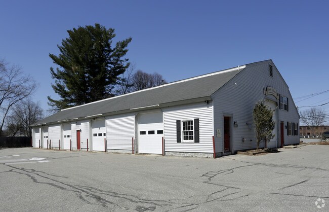
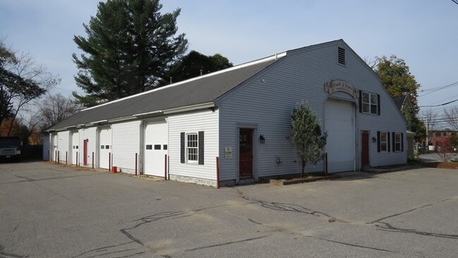
Property Record
15 Prescott St, Keene, NH 03431

Property Detail
15 Prescott St
595/ / 014/000 000/000
Cheshire
Industrialgeneral
New Hampshire
LD
14
B and X Area of moderate flood hazard, usually the area between the limits of the 100-year and 500-year floods.
0.42 AC
2025
Manchester/New Hampshire South Area
2025
Other Market Areas
971403
Keene, NH
7,193 SF
NEARBY LISTINGS FOR SALE OR LEASE
DEMOGRAPHICS near 15 Prescott St
1 mile
3 mile
5 mile
2025 Total Population
7,525
19,595
29,723
2030 Population
7,655
19,880
30,150
Pop Growth 2025-2030
+ 1.73%
+ 1.45%
+ 1.44%
Average Age
37
41
43
2025 Total Households
3,066
8,370
12,604
HH Growth 2025-2030
+ 2.38%
+ 1.74%
+ 1.66%
Median Household Inc
$75,562
$80,853
$85,332
Avg Household Size
2.00
2.10
2.10
2025 Avg HH Vehicles
1.00
2.00
2.00
Median Home Value
$260,727
$277,499
$286,235
Median Year Built
1948
1954
1965
Nearby Places
Map Layers
Map Styles
 Street
 Aerial
Layers
 Traffic
 Biking
Places
Listings with unknown addresses are not visible on the map
- Restaurants
- Banks
- Shops
- Fitness
- Groceries
Nearby Properties
Address
Land Use
TOTAL SIZE
Lot Size
Zoning
Address
Land Use
TOTAL SIZE
Lot Size
Zoning
Address
Land Use
TOTAL SIZE
Lot Size
Zoning
14.33 AC
HC
Address
Land Use
TOTAL SIZE
Lot Size
Zoning
25 AC
LD
Address
Land Use
TOTAL SIZE
Lot Size
Zoning
89,864 SF
14.77 AC
R
Address
Land Use
TOTAL SIZE
Lot Size
Zoning
13.20 AC
COM
Address
Land Use
TOTAL SIZE
Lot Size
Zoning
4.95 AC
DT-C
Address
Land Use
TOTAL SIZE
Lot Size
Zoning
195,466 SF
18.66 AC
COM
Address
Land Use
TOTAL SIZE
Lot Size
Zoning
122,326 SF
10 AC
COM
Address
Land Use
TOTAL SIZE
Lot Size
Zoning
13.43 AC
BGR
Address
Land Use
TOTAL SIZE
Lot Size
Zoning
14.97 AC
COM
Address
Land Use
TOTAL SIZE
Lot Size
Zoning
4.10 AC
BGR
Address
Land Use
TOTAL SIZE
Lot Size
Zoning
6.49 AC
COM
Address
Land Use
TOTAL SIZE
Lot Size
Zoning
86,070 SF
HD
Address
Land Use
TOTAL SIZE
Lot Size
Zoning
13,950 SF
18.60 AC
CON
Address
Land Use
TOTAL SIZE
Lot Size
Zoning
54,874 SF
HD
Address
Land Use
TOTAL SIZE
Lot Size
Zoning
61,775 SF
HD
Address
Land Use
TOTAL SIZE
Lot Size
Zoning
84,905 SF
HD
Address
Land Use
TOTAL SIZE
Lot Size
Zoning
78,178 SF
HD
Address
Land Use
TOTAL SIZE
Lot Size
Zoning
85,136 SF
HD
Address
Land Use
TOTAL SIZE
Lot Size
Zoning
114,408 SF
11.86 AC
COM
Address
Land Use
TOTAL SIZE
Lot Size
Zoning
65,462 SF
1.01 AC
HD
Address
Land Use
TOTAL SIZE
Lot Size
Zoning
97,804 SF
2.51 AC
BUSINE
Address
Land Use
TOTAL SIZE
Lot Size
Zoning
91,428 SF
16.43 AC
COMM/I
Address
Land Use
TOTAL SIZE
Lot Size
Zoning
Address
Land Use
TOTAL SIZE
Lot Size
Zoning
72,808 SF
5.54 AC
COM
Address
Land Use
TOTAL SIZE
Lot Size
Zoning
48,530 SF
1.34 AC
LD
Address
Land Use
TOTAL SIZE
Lot Size
Zoning
121,757 SF
5.20 AC
DT-G
Address
Land Use
TOTAL SIZE
Lot Size
Zoning
77,191 SF
5.60 AC
COM
Address
Land Use
TOTAL SIZE
Lot Size
Zoning
48,993 SF
HD
Address
Land Use
TOTAL SIZE
Lot Size
Zoning
73,340 SF
HD
The World's #1 Commercial Real Estate Marketplace
Connect with us
© 2026 CoStar Group
The information above has been obtained from sources believed reliable. While we do not doubt its accuracy we have not verified it and make no guarantee, warranty or representation about it. It is your responsibility to independently confirm its accuracy and completeness. Any projections, opinions, assumptions, or estimates used are for example only and do not represent the current or future performance of the property. The value of this transaction to you depends on tax and other factors which should be evaluated by your tax, financial, and legal advisors. You and your advisors should conduct a careful, independent investigation of the property to determine to your satisfaction the suitability of the property for your needs.