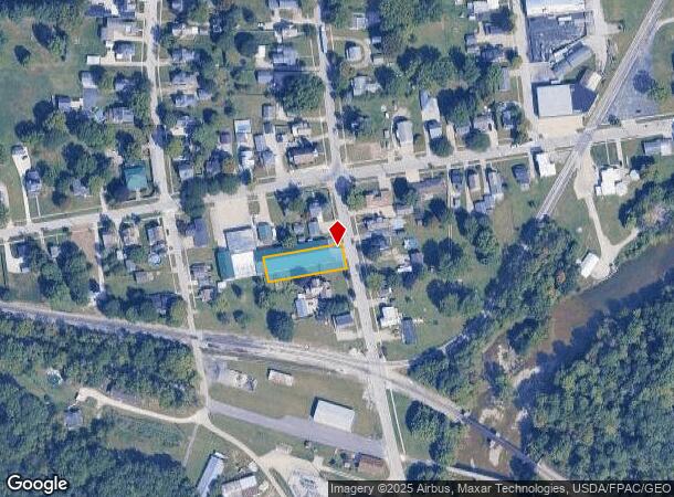
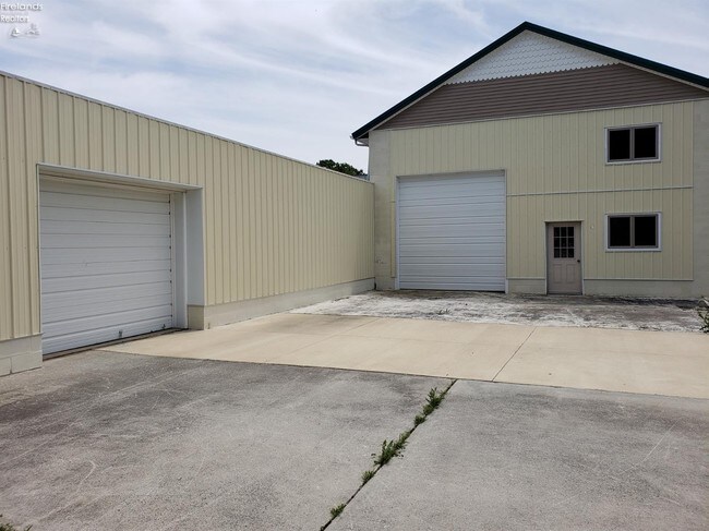
Property Record
15 Ridge St S, Monroeville, OH 44847

NEARBY LISTINGS FOR SALE OR LEASE
-
-
View all Monroeville listings for sale on LoopNet.com
Property Detail
15 Ridge St S
42-048C-02-006-0000
LOT 237
Publicstorage
Huron
X
Ohio
39077C0177D
237
2024
0.29 AC
2024
Huron County
915900
Cleveland
12,000 SF
Norwalk, OH
DEMOGRAPHICS near 15 Ridge St S
1 Mile
3 Mile
5 Mile
2024 Total Population
1,390
2,030
14,959
2029 Population
1,362
1,985
14,892
Pop Growth 2024-2029
(2.01%)
(2.22%)
(0.45%)
Average Age
41
41
41
2024 Total Households
556
810
6,057
HH Growth 2024-2029
(2.34%)
(2.35%)
(0.48%)
Median Household Inc
$64,904
$65,519
$56,448
Avg Household Size
2.50
2.50
2.40
2024 Avg HH Vehicles
2.00
2.00
2.00
Median Home Value
$148,113
$152,823
$156,891
Median Year Built
1948
1949
1966
Nearby Places
Map Layers
Map Styles
 Street
 Aerial
- Restaurants
- Banks
- Shops
- Fitness
- Groceries
SALE & LEASE HISTORY
LISTING DATE
SALE/LEASE

Jul 10, 2019
For Sale
Nearby Properties
Address
Land Use
TOTAL SIZE
Lot Size
Zoning
Address
Land Use
TOTAL SIZE
Lot Size
Zoning
28,380 SF
1.46 AC
Address
Land Use
TOTAL SIZE
Lot Size
Zoning
3,994 SF
2.54 AC
Address
Land Use
TOTAL SIZE
Lot Size
Zoning
414.96 AC
Address
Land Use
TOTAL SIZE
Lot Size
Zoning
5,865 SF
5.30 AC
Address
Land Use
TOTAL SIZE
Lot Size
Zoning
35,997 SF
8.28 AC
Address
Land Use
TOTAL SIZE
Lot Size
Zoning
181.52 AC
Address
Land Use
TOTAL SIZE
Lot Size
Zoning
130.25 AC
Address
Land Use
TOTAL SIZE
Lot Size
Zoning
1,520 SF
1.26 AC
Address
Land Use
TOTAL SIZE
Lot Size
Zoning
127.42 AC
Address
Land Use
TOTAL SIZE
Lot Size
Zoning
2,218 SF
105 AC
Address
Land Use
TOTAL SIZE
Lot Size
Zoning
1,808 SF
88 AC
Address
Land Use
TOTAL SIZE
Lot Size
Zoning
112.27 AC
Address
Land Use
TOTAL SIZE
Lot Size
Zoning
134.07 AC
Address
Land Use
TOTAL SIZE
Lot Size
Zoning
3,032 SF
90.96 AC
Address
Land Use
TOTAL SIZE
Lot Size
Zoning
107.13 AC
Address
Land Use
TOTAL SIZE
Lot Size
Zoning
138.94 AC
Address
Land Use
TOTAL SIZE
Lot Size
Zoning
1,280 SF
10 AC
Address
Land Use
TOTAL SIZE
Lot Size
Zoning
1,260 SF
97.77 AC
Address
Land Use
TOTAL SIZE
Lot Size
Zoning
2,946 SF
86.48 AC
Address
Land Use
TOTAL SIZE
Lot Size
Zoning
1,560 SF
116.67 AC
Address
Land Use
TOTAL SIZE
Lot Size
Zoning
102.04 AC
Address
Land Use
TOTAL SIZE
Lot Size
Zoning
2,113 SF
109.62 AC
Address
Land Use
TOTAL SIZE
Lot Size
Zoning
1,598 SF
78.28 AC
Address
Land Use
TOTAL SIZE
Lot Size
Zoning
2,432 SF
81 AC
Address
Land Use
TOTAL SIZE
Lot Size
Zoning
1,620 SF
83.43 AC
Address
Land Use
TOTAL SIZE
Lot Size
Zoning
93.07 AC
Address
Land Use
TOTAL SIZE
Lot Size
Zoning
94.13 AC
Address
Land Use
TOTAL SIZE
Lot Size
Zoning
1,300 SF
80 AC
Address
Land Use
TOTAL SIZE
Lot Size
Zoning
1,275 SF
104 AC
Address
Land Use
TOTAL SIZE
Lot Size
Zoning
2,092 SF
113.20 AC
The World's #1 Commercial Real Estate Marketplace
Connect with us
© 2025 CoStar Group
The information above has been obtained from sources believed reliable. While we do not doubt its accuracy we have not verified it and make no guarantee, warranty or representation about it. It is your responsibility to independently confirm its accuracy and completeness. Any projections, opinions, assumptions, or estimates used are for example only and do not represent the current or future performance of the property. The value of this transaction to you depends on tax and other factors which should be evaluated by your tax, financial, and legal advisors. You and your advisors should conduct a careful, independent investigation of the property to determine to your satisfaction the suitability of the property for your needs.