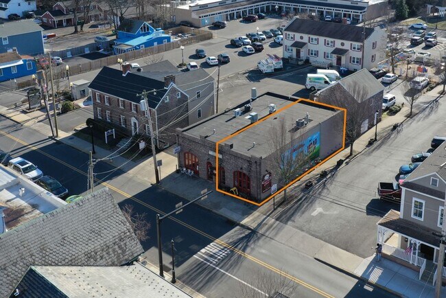
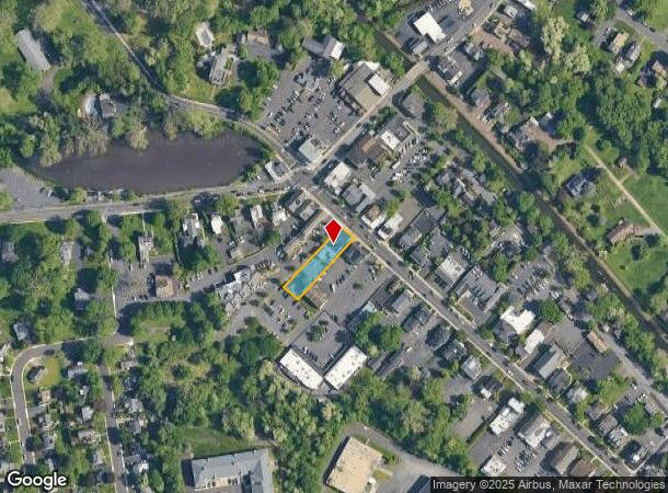
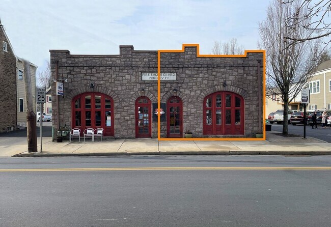
Property Record
15 S Main St, Doylestown, PA 18901
NEARBY LISTINGS FOR SALE OR LEASE
Property Detail
15 S Main St
Philadelphia-Camden-Wilmington, PA-NJ-DE-MD
Lou Asack
54-003-100
42X187IRR LOT #3 WS S MAIN ST 157S OF W AFTON (SR332)
Storebuilding
Bucks
X
Pennsylvania
34021C0202F
3
2024
0.18 AC
2025
Lower Bucks County
104702
Philadelphia
3,048 SF
DEMOGRAPHICS near 15 S Main St
1 Mile
3 Mile
5 Mile
2024 Total Population
7,077
56,253
173,193
2029 Population
6,992
55,787
172,209
Pop Growth 2024-2029
(1.20%)
(0.83%)
(0.57%)
Average Age
44
43
42
2024 Total Households
3,044
21,715
66,377
HH Growth 2024-2029
(1.31%)
(0.87%)
(0.66%)
Median Household Inc
$120,209
$112,368
$86,974
Avg Household Size
2.30
2.50
2.50
2024 Avg HH Vehicles
2.00
2.00
2.00
Median Home Value
$467,646
$426,379
$350,752
Median Year Built
1965
1969
1963
Nearby Places
Map Layers
Map Styles
 Street
 Aerial
- Restaurants
- Banks
- Shops
- Fitness
- Groceries
PUBLIC TRANSPORTATION
COMMUTER RAIL
Yardley (R3 - Southeastern Pennsylvania Transportation Authority Regional Rail (SEPTA Regional Rail))
DRIVE
WALK
Distance
Yardley (R3 - Southeastern Pennsylvania Transportation Authority Regional Rail (SEPTA Regional Rail))
2 min
14 min
0.8 mi
West Trenton (R3 - Southeastern Pennsylvania Transportation Authority Regional Rail (SEPTA Regional Rail))
DRIVE
WALK
Distance
West Trenton (R3 - Southeastern Pennsylvania Transportation Authority Regional Rail (SEPTA Regional Rail))
9 min
5.0 mi
AIRPORT
Trenton Mercer
DRIVE
WALK
Distance
Trenton Mercer
8 min
4.4 mi
Freight Ports
Port of Philadelphia
DRIVE
WALK
Distance
Port of Philadelphia
39 min
27.0 mi
SALE & LEASE HISTORY
LISTING DATE
SALE/LEASE

Feb 24, 2023
For Lease
Feb 16, 2023
For Lease
Feb 15, 2023
For Lease
Nearby Properties
Address
Land Use
TOTAL SIZE
Lot Size
Zoning
Address
Land Use
TOTAL SIZE
Lot Size
Zoning
225.40 AC
R-1
Address
Land Use
TOTAL SIZE
Lot Size
Zoning
1,996 SF
125 AC
RA
Address
Land Use
TOTAL SIZE
Lot Size
Zoning
4,320 SF
12.06 AC
PRO
Address
Land Use
TOTAL SIZE
Lot Size
Zoning
96.60 AC
OP-2
Address
Land Use
TOTAL SIZE
Lot Size
Zoning
117.50 AC
OP-1
Address
Land Use
TOTAL SIZE
Lot Size
Zoning
42.80 AC
IP-1
Address
Land Use
TOTAL SIZE
Lot Size
Zoning
27.21 AC
PRO
Address
Land Use
TOTAL SIZE
Lot Size
Zoning
104.60 AC
IP-1
Address
Land Use
TOTAL SIZE
Lot Size
Zoning
23.50 AC
R-2
Address
Land Use
TOTAL SIZE
Lot Size
Zoning
0.59 AC
RM
Address
Land Use
TOTAL SIZE
Lot Size
Zoning
11.40 AC
Address
Land Use
TOTAL SIZE
Lot Size
Zoning
64.33 AC
R-2
Address
Land Use
TOTAL SIZE
Lot Size
Zoning
Address
Land Use
TOTAL SIZE
Lot Size
Zoning
8.93 AC
Address
Land Use
TOTAL SIZE
Lot Size
Zoning
5,254 SF
245.70 AC
R-1
Address
Land Use
TOTAL SIZE
Lot Size
Zoning
11.09 AC
Address
Land Use
TOTAL SIZE
Lot Size
Zoning
26.20 AC
OP-1
Address
Land Use
TOTAL SIZE
Lot Size
Zoning
63.40 AC
R-1
Address
Land Use
TOTAL SIZE
Lot Size
Zoning
1.30 AC
Address
Land Use
TOTAL SIZE
Lot Size
Zoning
8.46 AC
RA
Address
Land Use
TOTAL SIZE
Lot Size
Zoning
35.41 AC
R-M
Address
Land Use
TOTAL SIZE
Lot Size
Zoning
Address
Land Use
TOTAL SIZE
Lot Size
Zoning
17,832 SF
26.01 AC
RM
Address
Land Use
TOTAL SIZE
Lot Size
Zoning
20.71 AC
R-2
Address
Land Use
TOTAL SIZE
Lot Size
Zoning
27.82 AC
R-M
Address
Land Use
TOTAL SIZE
Lot Size
Zoning
Address
Land Use
TOTAL SIZE
Lot Size
Zoning
34.18 AC
R-2
Address
Land Use
TOTAL SIZE
Lot Size
Zoning
44.90 AC
R-2
Address
Land Use
TOTAL SIZE
Lot Size
Zoning
6,444 SF
44.01 AC
RA
Address
Land Use
TOTAL SIZE
Lot Size
Zoning
30.72 AC
R-1
The World's #1 Commercial Real Estate Marketplace
Connect with us
© 2026 CoStar Group
The information above has been obtained from sources believed reliable. While we do not doubt its accuracy we have not verified it and make no guarantee, warranty or representation about it. It is your responsibility to independently confirm its accuracy and completeness. Any projections, opinions, assumptions, or estimates used are for example only and do not represent the current or future performance of the property. The value of this transaction to you depends on tax and other factors which should be evaluated by your tax, financial, and legal advisors. You and your advisors should conduct a careful, independent investigation of the property to determine to your satisfaction the suitability of the property for your needs.